Fries Museum
The Fries Museum is a museum in Leeuwarden, the Netherlands.
History
Koningstraat and Turfmarkt (1881-2012)
The museum was founded on 13 April 1881 by the "Provincial Friesch Genootschap ter Beoefening van Friesche Geschied-, Oudheid- en Taalkunde", a society for the preservation of Frisian culture that was itself was founded in 1827 and needed a place to exhibit the various artifacts it had gathered together. In the early decades this local museum, an offshoot of the Antiquarisch Kabinet van Friesland, was focussed on typical Hindeloper goods and other Frisian curiosities that had been collected by the local preacher-writer Joost Hiddes Halbertsma. The first historical exhibition of 1877, however, which had over 1500 items on loan and attracted many visitors, led to an unexpected profit of 17,000 guilders, and the museum was able to purchase a new property on the Koningstraat, the former "Eysinga house", where the museum opened its doors in 1881.
A further important boost to the collection occurred when William III of the Netherlands bequeathed many portraits from the collection of the Stadhouderlijk Hof. In 1892 a new wing was built to house the growing collection, with a special viewing room for the paintings with a large skylight.
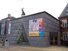 Entrance to the Fries Museum on the Turfmarkt in Leeuwarden
 Eysinga house, now a rijksmonument
_Leeuwarden_NL.jpg) Turfmarkt 18-20, part of the museum and now rijksmonuments
Turfmarkt 18-20, part of the museum and now rijksmonuments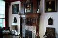 Bishop's room
Museum Today
With approximately 170,000 objects of art, culture and history the museum is the country's largest Frisian provincial museum. A centerpiece of the museum is de zilveren "Poptaschat", a silver goblet with its lid from the 17th century. The museum is also home to the legendary sword of Grote Pier. The Mata Hari hall is dedicated to the life of the dancer and spy, who was born in 1876 in Leeuwarden as Margaretha Zelle. The museum has the largest collection of works by the local late 16th century portrait painter Adriaen van Cronenburg.
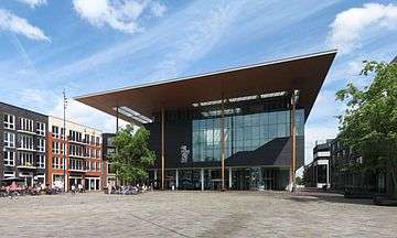
The new building (2013) on Wilhelminaplein opened on 13 September 2013.
| Wikimedia Commons has media related to Fries Museum. |
References
- Fries Museum; Nederlandse Musea II, Geschreven door de stêf van het museum, Skreaun troch de stef fan it museum; Joh. Enschedé en Zonen Grafische Inrichting B.V., Haarlem, 1978
External links
Coordinates: 53°11′59″N 5°47′40″E / 53.199722°N 5.794444°E