Fry's Gap, Texas
| Fry's Gap, Texas | |
|---|---|
| Unincorporated community | |
 Fry's Gap  Fry's Gap | |
| Coordinates: 31°59′15″N 95°20′32″W / 31.98750°N 95.34222°WCoordinates: 31°59′15″N 95°20′32″W / 31.98750°N 95.34222°W | |
| Country | United States |
| State | Texas |
| County | Cherokee |
| Elevation | 558 ft (170 m) |
| Time zone | Central (CST) (UTC-6) |
| • Summer (DST) | CDT (UTC-5) |
| Area code(s) | 430 & 903 |
| GNIS feature ID | 1357795[1] |
Fry's Gap is an unincorporated community in Cherokee County, located in the U.S. state of Texas.[1]
References
External links
Municipalities and communities of Cherokee County, Texas, United States | ||
|---|---|---|
| Cities | 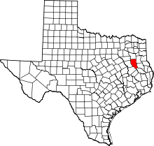 | |
| Towns | ||
| CDP | ||
| Other unincorporated communities | ||
| Ghost towns | ||
| Footnotes | ‡This populated place also has portions in an adjacent county or counties | |
This article is issued from Wikipedia - version of the 7/31/2016. The text is available under the Creative Commons Attribution/Share Alike but additional terms may apply for the media files.