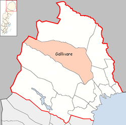
Gällivare Municipality
| Gällivare Municipality Gällivare kommun | ||
|---|---|---|
| Municipality | ||
| ||
 | ||
| Country | Sweden | |
| County | Norrbotten County | |
| Seat | Gällivare | |
| Area[1] | ||
| • Total | 16,818.22 km2 (6,493.55 sq mi) | |
| • Land | 15,705.15 km2 (6,063.79 sq mi) | |
| • Water | 1,113.07 km2 (429.76 sq mi) | |
| Area as of January 1, 2014. | ||
| Population (June 30, 2016)[2] | ||
| • Total | 18,041 | |
| • Density | 1.1/km2 (2.8/sq mi) | |
| Time zone | CET (UTC+1) | |
| • Summer (DST) | CEST (UTC+2) | |
| ISO 3166 code | SE | |
| Province | Lapland | |
| Municipal code | 2523 | |
| Website | www.gellivare.se | |
Gällivare Municipality (Swedish: Gällivare kommun, Finnish: Jällivaaran kunta, Northern Sami: Jiellevárri gielda or Váhčira gielda) is a municipality in Norrbotten County in northern Sweden. Its seat is Gällivare. The municipality is the third biggest in Sweden.
Gällivare Municipality also hosts an airport, Gällivare Airport. It is the nearest airport to the national parks Sarek and Padjelanta, making it popular for hikers.
Gällivare is also the central place for The Firstborn Laestadianism.
Gällivare Municipality is a multilingual municipality, as a sizeable share of the population is made up of Finnish and Sami speakers.
Nearly 40 cases of the rare genetic disorder CIPA have been reported in Gällivare.
Localities
There are six localities (or urban areas) in Gällivare Municipality:[3]
| # | Locality | Population |
|---|---|---|
| 1 | Gällivare | 8,480 |
| 2 | Malmberget | 6,017 |
| 3 | Koskullskulle | 899 |
| 4 | Hakkas | 383 |
| 5 | Ullatti | 230 |
| 6 | Tjautjas/Čavččas | 216 |
The municipal seat in bold
Government and politics
Distribution of the 41 seats in the municipal council after the 2010 election:
- Social Democratic Party 21
- Moderate Party 7
- Left Party 7
- Communist Party of Sweden 2
- Norrbottens Sjukvårdsparti 2
- Sweden Democrats 1
- Green Party 1
Results of the Swedish general election, 2010 in Gällivare:
- Social Democratic Party 55.8%
- Moderate Party 14.2%
- Left Party 13.6%
- Sweden Democrats 5.0%
- Green Party 3.8%
- Christian Democrats 2.4%
- Liberal People's Party 2.3%
- Centre Party 1.7%
Sister cities
Gällivare Municipality has four sister cities:
Annual festivals
References
- ↑ "Statistiska centralbyrån, Kommunarealer den 1 januari 2014" (Microsoft Excel) (in Swedish). Statistics Sweden. Retrieved 2014-04-18.
- ↑ "Folkmängd i riket, län och kommuner 30 juni 2016" (in Swedish). Statistics Sweden. August 17, 2016. Retrieved August 17, 2016.
- ↑ Statistics Sweden as of December 31, 2005
External links
| Wikimedia Commons has media related to Gällivare Municipality. |
- Gällivare Municipality - Official site (Swedish)
- Town twinning ceremony with Barga, Italy
Municipalities and seats of Norrbotten County | ||
|---|---|---|
| Municipalities | ||
| Municipal seats | ||
Coordinates: 67°07′N 20°45′E / 67.117°N 20.750°E