Gacé
For other uses, see Gace (disambiguation).
| Gacé | |
|---|---|
|
Gacé Castle | |
 Gacé | |
|
Location within Normandy region  Gacé | |
| Coordinates: 48°47′38″N 0°17′52″E / 48.7939°N 0.2978°ECoordinates: 48°47′38″N 0°17′52″E / 48.7939°N 0.2978°E | |
| Country | France |
| Region | Normandy |
| Department | Orne |
| Arrondissement | Argentan |
| Canton | Gacé |
| Intercommunality | Communauté de communes de la Région de Gacé |
| Government | |
| • Mayor (2008–2014) | François Dreux |
| Area1 | 6.5 km2 (2.5 sq mi) |
| Population (2012)2 | 2,031 |
| • Density | 310/km2 (810/sq mi) |
| Time zone | CET (UTC+1) |
| • Summer (DST) | CEST (UTC+2) |
| INSEE/Postal code | 61181 / 61230 |
| Elevation |
179–316 m (587–1,037 ft) (avg. 186 m or 610 ft) |
| Website | www.gace.fr |
|
1 French Land Register data, which excludes lakes, ponds, glaciers > 1 km² (0.386 sq mi or 247 acres) and river estuaries. 2 Population without double counting: residents of multiple communes (e.g., students and military personnel) only counted once. | |
.jpg)
Gacé is a commune in the Orne department in Lower-Normandy, north-western France.
Heraldry
.svg.png) |
The arms of Gacé are blazoned: Argent, a lion gules, crowned Or, langued azure. |
Administration
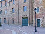
City Hall in the Castle
Twin towns
See also
References
| Wikimedia Commons has media related to Gacé. |
This article is issued from Wikipedia - version of the 3/19/2016. The text is available under the Creative Commons Attribution/Share Alike but additional terms may apply for the media files.