Cedar County, Nebraska
| Cedar County, Nebraska | |
|---|---|
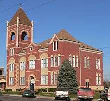 Cedar County courthouse in Hartington | |
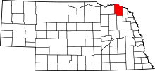 Location in the U.S. state of Nebraska | |
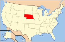 Nebraska's location in the U.S. | |
| Founded | 1857 |
| Seat | Hartington |
| Largest city | Hartington |
| Area | |
| • Total | 746 sq mi (1,932 km2) |
| • Land | 740 sq mi (1,917 km2) |
| • Water | 5.5 sq mi (14 km2), 0.7% |
| Population | |
| • (2010) | 8,852 |
| • Density | 12/sq mi (5/km²) |
| Congressional district | 3rd |
| Time zone | Central: UTC-6/-5 |
| Website |
www |
Cedar County is a county in the U.S. state of Nebraska. As of the 2010 census, the population was 8,852.[1] Its county seat is Hartington.[2] The county was formed in 1857 and named for the many cedars that grow there.[3][4][5]
In the Nebraska license plate system, Cedar County is represented by the prefix 13 (it had the 13th-largest number of vehicles registered in the county when the license plate system was established in 1922).
Geography
According to the U.S. Census Bureau, the county has an area of 746 square miles (1,930 km2), of which 740 square miles (1,900 km2) is land and 5.5 square miles (14 km2) (0.7%) is water.[6]
Major highways
Adjacent counties
- Clay County, South Dakota - northeast
- Dixon County, Nebraska - east
- Wayne County, Nebraska - southeast
- Pierce County, Nebraska - southwest
- Knox County, Nebraska - west
- Yankton County, South Dakota - northwest
National protected area
Demographics
| Historical population | |||
|---|---|---|---|
| Census | Pop. | %± | |
| 1860 | 246 | — | |
| 1870 | 1,032 | 319.5% | |
| 1880 | 2,899 | 180.9% | |
| 1890 | 7,028 | 142.4% | |
| 1900 | 12,467 | 77.4% | |
| 1910 | 15,191 | 21.8% | |
| 1920 | 16,225 | 6.8% | |
| 1930 | 16,427 | 1.2% | |
| 1940 | 15,126 | −7.9% | |
| 1950 | 13,843 | −8.5% | |
| 1960 | 13,368 | −3.4% | |
| 1970 | 12,192 | −8.8% | |
| 1980 | 11,375 | −6.7% | |
| 1990 | 10,131 | −10.9% | |
| 2000 | 9,615 | −5.1% | |
| 2010 | 8,852 | −7.9% | |
| Est. 2015 | 8,564 | [7] | −3.3% |
| U.S. Decennial Census[8] 1790-1960[9] 1900-1990[10] 1990-2000[11] 2010-2013[1] | |||
As of the census[12] of 2000, there were 9,615 people, 3,623 households, and 2,565 families residing in the county. The population density was 13 people per square mile (5/km²). There were 4,200 housing units at an average density of 6 per square mile (2/km²). The racial makeup of the county was 99.07% White, 0.10% Black or African American, 0.20% Native American, 0.04% Asian, 0.01% Pacific Islander, 0.18% from other races, and 0.40% from two or more races. 0.43% of the population were Hispanic or Latino of any race. 69.8% were of German and 5.1% American ancestry according to Census 2000.
There were 3,623 households out of which 34.80% had children under the age of 18 living with them, 63.60% were married couples living together, 4.30% had a female householder with no husband present, and 29.20% were non-families. 27.00% of all households were made up of individuals and 15.70% had someone living alone who was 65 years of age or older. The average household size was 2.60 and the average family size was 3.20.
In the county the population was spread out with 29.40% under the age of 18, 6.00% from 18 to 24, 24.20% from 25 to 44, 20.30% from 45 to 64, and 20.00% who were 65 years of age or older. The median age was 39 years. For every 100 females there were 100.10 males. For every 100 females age 18 and over, there were 97.10 males.
The median income for a household in the county was $33,435, and the median income for a family was $39,422. Males had a median income of $26,707 versus $18,370 for females. The per capita income for the county was $15,514. About 6.30% of families and 9.10% of the population were below the poverty line, including 10.70% of those under age 18 and 9.70% of those age 65 or over.
Communities
- Belden
- Bow Valley
- Coleridge
- Fordyce
- Hartington (county seat)
- Laurel
- Magnet
- Obert
- Randolph
- St. Helena
- St. James
- Wynot
- South Yankton
See also
| Wikimedia Commons has media related to Cedar County, Nebraska. |
References
- 1 2 "State & County QuickFacts". United States Census Bureau. Retrieved September 17, 2013.
- ↑ "Find a County". National Association of Counties. Archived from the original on 2011-05-31. Retrieved 2011-06-07.
- ↑ Fitzpatrick, Lilian Linder (1925). Nebraska Place-Names. Lincoln: University of Nebraska Studies in Language, Literature, and Criticism. p. 33. Retrieved December 18, 2014.
- ↑ Andreas, A. T. (1882). "Andreas' History of the State of Nebraska". The Kansas Collection. Retrieved December 18, 2014.
- ↑ "Cedar County". Nebraska Association of County Officials. Retrieved December 18, 2014.
- ↑ "2010 Census Gazetteer Files". United States Census Bureau. August 22, 2012. Retrieved December 6, 2014.
- ↑ "County Totals Dataset: Population, Population Change and Estimated Components of Population Change: April 1, 2010 to July 1, 2015". Retrieved July 2, 2016.
- ↑ "U.S. Decennial Census". United States Census Bureau. Archived from the original on May 11, 2015. Retrieved December 6, 2014.
- ↑ "Historical Census Browser". University of Virginia Library. Retrieved December 6, 2014.
- ↑ "Population of Counties by Decennial Census: 1900 to 1990". United States Census Bureau. Retrieved December 6, 2014.
- ↑ "Census 2000 PHC-T-4. Ranking Tables for Counties: 1990 and 2000" (PDF). United States Census Bureau. Retrieved December 6, 2014.
- ↑ "American FactFinder". United States Census Bureau. Archived from the original on 2013-09-11. Retrieved 2008-01-31.
 |
Yankton County, South Dakota | Clay County, South Dakota | | |
| Knox County | |
Dixon County | ||
| ||||
| | ||||
| Pierce County | Wayne County |
Municipalities and communities of Cedar County, Nebraska, United States | ||
|---|---|---|
| Cities | ||
| Villages | ||
| CDPs | ||
| Unincorporated communities | ||
Coordinates: 42°36′N 97°15′W / 42.60°N 97.25°W