Georgia State Route 140
| ||||
|---|---|---|---|---|
 | ||||
| Route information | ||||
| Maintained by GDOT | ||||
| Length: | 78.6 mi[1] (126.5 km) | |||
| Major junctions | ||||
| West end: |
| |||
|
| ||||
| East end: |
| |||
| Location | ||||
| Counties: | Floyd, Bartow, Cherokee, Fulton, Gwinnett | |||
| Highway system | ||||
| ||||

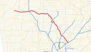
State Route 140 (SR 140) is a 78.6-mile-long (126.5 km) state highway in the northwestern part of the U.S. state of Georgia. It connects the Armuchee and Norcross areas, within portions of Floyd, Bartow, Cherokee, Fulton, Gwinnett counties.
Route description
SR 140 begins at an intersection with US 27/SR 1 near Armuchee, within Floyd County. It travels east, crosses over the Oostanaula River, and meets SR 53 (New Calhoun Highway NE). It crosses into Bartow County and enters Adairsville. In town, it has an intersection with US 41/SR 3 (Joe Frank Harris Parkway) and an interchange with Interstate 75 (I-75; Larry McDonald Memorial Highway). It continues to the east and then curves to the southeast to meet US 411/SR 61, just north of Rydal. It heads east into Cherokee County and then curves to the southeast. In Waleska, the highway intersects SR 108 (Fincher Road). The roadway continues to the southeast and enters Canton. Here, it has an intersection with SR 5 Connector (Reinhardt College Parkway). Farther to the south it has a concurrency with SR 5 Business. The two routes curve to the southwest, cross over the Etowah River, and meet SR 20 (Marietta Highway), which joins the concurrency for less than 1 mile (1.6 km). At Interstate 575/SR 5 (Phillip M. Landrum Memorial Highway), SR 5 Business ends, SR 20 joins the freeway to the northeast, and SR 140 curves to the northeast, before heading southeast again. SR 140 enters Fulton County. In the county is SR 372 (Crabapple Road). The route enters Roswell, where it joins a concurrency of SR 9/SR 120 (Alpharetta Highway). At the Roswell Town Center, the three routes meet the eastern terminus of SR 92 (East Crossville Road). At this intersection, SR 9/SR 120 depart to the southwest, while SR 140 continues to the southeast. Less than 1 mile (1.6 km) later is US 19/SR 400 (Hospitality Highway). To the southeast, it crosses over the Chattahoochee River onto the Fulton–Gwinnett County for a short while, before it enters Gwinnett County proper. Just to the west of Norcross, SR 140 meets SR 141 (Peachtree Industrial Boulevard). Shortly to the southeast, in town, it intersects US 23/SR 13 (Buford Highway). It continues to the southeast until it meets its eastern terminus, an interchange with I-85 (Veterans Parkway), just south of Norcross.[1]
The section of SR 140 from Roswell to its eastern terminus is the only part of the route that is included in the National Highway System, a system of roadways important to the nation's economy, defense, and mobility.[2]
Major intersections
| County | Location | mi[1] | km | Destinations | Notes |
|---|---|---|---|---|---|
| Floyd | | 0.0 | 0.0 | Western terminus | |
| Oostanaula River | 3.1 | 5.0 | Unnamed bridge | Crossing over the Oostanaula River | |
| | 7.7 | 12.4 | |||
| Bartow | Adairsville | 14.7 | 23.7 | ||
| 15.9 | 25.6 | I-75, exit 306 | |||
| | 28.4 | 45.7 | |||
| Cherokee | Waleska | 39.6 | 63.7 | ||
| Canton | 45.7 | 73.5 | Southern terminus of SR 5 Connector | ||
| 46.6 | 75.0 | Western end of SR 5 Business concurrency | |||
| 47.8 | 76.9 | Unnamed bridge | Crossing over the Etowah River | ||
| 48.2 | 77.6 | Western end of SR 20 concurrency | |||
| 48.8 | 78.5 | I-575/SR 5, exit 16A; eastern end of SR 5 Business concurrency | |||
| 49.0 | 78.9 | I-575/SR 5, exit 16A; eastern end of SR 20 concurrency | |||
| Little River | 59.7 | 96.1 | Unnamed bridge; crossing over the Little River, marking the Cherokee–Fulton county line | ||
| Fulton | Roswell | 63.0 | 101.4 | Southern terminus | |
| 66.0 | 106.2 | Western end of SR 9/SR 120 concurrency | |||
| 66.3 | 106.7 | Eastern end of SR 9/SR 120 concurrency; eastern terminus of SR 92 | |||
| 67.7 | 109.0 | US 19/SR 400, exit 7 | |||
| Chattahoochee River | 72.9 | 117.3 | Unnamed bridge; crossing over the Chattahoochee River, marking the Fulton–Gwinnett county line | ||
| Gwinnett | | 75.5 | 121.5 | ||
| Norcross | 77.0 | 123.9 | |||
| | 78.6 | 126.5 | I-85, exit 99; eastern terminus | ||
1.000 mi = 1.609 km; 1.000 km = 0.621 mi
| |||||
See also
-
.svg.png) Georgia (U.S. state) portal
Georgia (U.S. state) portal -
 U.S. Roads portal
References
- 1 2 3 Google (June 28, 2013). "Route of SR 140" (Map). Google Maps. Google. Retrieved June 28, 2013.
- ↑ "National Highway System: Georgia" (PDF). United States Department of Transportation. October 1, 2012. Retrieved July 1, 2013.
External links
-
 Media related to Georgia State Route 140 at Wikimedia Commons
 - Georgia Roads (Routes 121 - 140)
- Georgia State Route 140 on State-Ends.com