Georgia State Route 328
| ||||
|---|---|---|---|---|
| Gumlog Road | ||||
 | ||||
| Route information | ||||
| Maintained by GDOT | ||||
| Length: | 9.8 mi[1] (15.8 km) | |||
| Existed: | June 1, 1963[2][3] – present | |||
| Major junctions | ||||
| West end: |
| |||
| East end: |
| |||
| Location | ||||
| Counties: | Franklin, Stephens | |||
| Highway system | ||||
| ||||

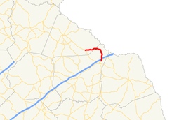
State Route 328 (SR 328) is an arc-shaped 9.8-mile-long (15.8 km) state highway in the northeast part of the U.S. state of Georgia. The route connects Avalon and Lavonia and provides access to Lake Hartwell and Tugaloo State Park. It is known as Gumlog Road for its entire length.
Route description
SR 328 begins at an intersection with SR 17 in Avalon, in Stephens County. It travels in a roughly eastern direction and intersects Brookhaven Circle, the former path of SR 336. The highway travels through the Gumlog area of Martin and enters Franklin County and travels through the Gumlog precinct, G.M.D. 213. This section of Gumlog Road is a typical ridge road on the Savanna river system that runs down to a river wonderfully described in the book "Tobacco Road." On the South side of the ridge is Gumlog Creek, and on the north side of the ridge is Eastanollee Estuary, so called because the public sees a large estuary from brookhave Road. It begins to curve to the southeast at Tugaloo State park road. It crosses over the Gumlog Cove section of Lake Hartwell. SR 328 then travels in a roughly southern direction. It crosses over, but does not have an interchange with Interstate 85 (I-85, Ernest Vandiver Highway). The route then curves to the south-southwest and meets its eastern terminus, an intersection with SR 59 (Vickery Street) in Lavonia. Here, the roadway continues as Edgewood Drive.[1]
SR 328 is not part of the National Highway System, a system of roadways important to the nation's economy, defense, and mobility.[4]
History
The roadway that would eventually become SR 328 was built in the mid-1950s on a nearly straight line from Avalon to just northeast of Livonia.[5][6] In the early 1960s, SR 328 was designated along its current alignment.[2][3]
Major intersections
| County | Location | mi[1] | km | Destinations | Notes |
|---|---|---|---|---|---|
| Stephens | Avalon | 0.0 | 0.0 | Western terminus | |
| Franklin | Lavonia | 9.8 | 15.8 | Eastern terminus of SR 328; roadway continues as Edgewood Drive. | |
| 1.000 mi = 1.609 km; 1.000 km = 0.621 mi | |||||
See also
-
.svg.png) Georgia (U.S. state) portal
Georgia (U.S. state) portal -
 U.S. Roads portal
References
- 1 2 3 Google (June 14, 2014). "Route of SR 328" (Map). Google Maps. Google. Retrieved June 14, 2014.
- 1 2 State Highway System and Other Principal Connecting Roads (PDF) (Map). Cartography by GSHD. State Highway Department of Georgia. June 1, 1960. Retrieved August 11, 2015.
- 1 2 State Highway System and Other Principal Connecting Roads (PDF) (Map). Cartography by GSHD. State Highway Department of Georgia. June 1, 1963. Retrieved August 11, 2015.
- ↑ National Highway System: (Draft) Georgia (PDF) (Map). Federal Highway Administration. November 15, 2013. Retrieved June 14, 2014.
- ↑ State Highway System and Other Principal Connecting Roads (PDF) (Map). Cartography by GSHD. State Highway Department of Georgia. June 1, 1954. Retrieved August 11, 2015.
- ↑ State Highway System and Other Principal Connecting Roads (PDF) (Map). Cartography by GSHD. State Highway Department of Georgia. June 1, 1955. Retrieved August 11, 2015.