Georgia State Route 45
| ||||
|---|---|---|---|---|
 | ||||
| Route information | ||||
| Maintained by GDOT | ||||
| Length: | 88.1 mi[1] (141.8 km) | |||
| Major junctions | ||||
| South end: |
| |||
|
| ||||
| North end: |
| |||
| Location | ||||
| Counties: | Seminole, Miller, Early, Calhoun, Terrell, Webster, Sumter | |||
| Highway system | ||||
| ||||

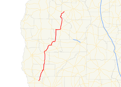
State Route 45 (SR 45) is a 88.1-mile-long (141.8 km) state highway that runs south-to-north through portions of Seminole, Miller, Early, Calhoun, Terrell, Webster, and Sumter counties in the southwestern part of the U.S. state of Georgia. The route connects Iron City and Plains, via Colquitt and Dawson.
Route description
SR 45 begins at an intersection with US 84/SR 38 (Dunham Street) in Iron City, in Seminole County. It passes through rural areas of the county and crosses into Miller County. It enters Colquitt, passing Pleasant Hill Cemetery and curving to the northwest. The highway intersects SR 91, which begins a concurrency through town, and the two turn to the northeast. Less than 1,000 feet (300 m) later, they intersect US 27/SR 1, which join the concurrency. The four highways head east, crossing over Spring Creek into the main part of town. They pass by the Colquitt City Cemetery. Then, SR 45/SR 91 split off onto West College Street. Just under 1,000 feet (300 m) later, they meet the northern terminus of SR 45 Connector (South 1st Street). At this intersection, SR 45/SR 91 turn to the north. One block later, SR 91 heads east on Main Street, while SR 45 continues to the north. Just before leaving town, it passes Miller County High School. SR 45 heads nearly due north and gradually curves to the north-northeast before entering Early County. The road curves to the northeast and then curves back to the north. It enters Damascus, where it has a very brief concurrency with SR 200. It heads nearly due-north and curves to the north-northwest and enters Arlington. It intersects SR 216 (Newton Road), which runs concurrent with SR 45 into the main part of town. Less than 2,000 feet (610 m) later, SR 62 (Blakely Road SW). At Maxwell Street, they cross into Calhoun County. At Cedar Street, they meet the southern terminus of SR 45 Alternate/SR 45 Truck. On block later, SR 62 departs to the east-northeast on Pioneer Road. Two blocks later, SR 45 and SR 216 diverge, with SR 216 turning left onto Morgan Road NW and SR 45 traveling to the northeast on Morgan Road NE. It passes through rural areas of the county and enters Morgan, where it has a very brief concurrency with SR 37. The highway heads north, curves to the northeast, and then to the east, crossing over Ichawaynochaway Creek. It intersects the western terminus of SR 234, at which point it turns north-northeast. A little distance later, it enters Terrell County on a fairly northern routing. It intersects US 82/SR 50 (Graves Highway), west of Dawson. At this intersection, SR 50 meets its eastern terminus, and US 82/SR 45 run concurrent into town. In town, they pass Dawson Country Club and cross over Brantley Creek, before intersecting SR 520. At this intersection, US 82 heads southeast, concurrent with SR 520 east, while SR 45 departs to the north, concurrent with SR 520 west. A few blocks later, they meet the western terminus of SR 32 (East Lee Street). The two routes leave town, and SR 45 heads north-northeast. It meets the southern terminus of SR 49. The highway continues in roughly a northern routing. Then it curves to the northwest, cutting across a small portion of Webster County, before curving back to the northeast and crossing over Kinchafoonee Creek. Immediately afterward, it enters Sumter County. SR 45 continues to the northeast and enters Plains. There, it meets the northern terminus of SR 308 (Bonds Trail Road). It heads north-northwest and meets its northern terminus, an intersection with US 280/SR 27 (Church Street).[1]
SR 45 is not part of the National Highway System, a system of roadways important to the nation's economy, defense, and mobility.[2]
Major intersections
| County | Location | mi[1] | km | Destinations | Notes | |||
|---|---|---|---|---|---|---|---|---|
| Seminole | Iron City | 0.0 | 0.0 | Southern terminus | ||||
| Miller | Colquitt | 12.2 | 19.6 | Southern end of SR 91 concurrency | ||||
| 12.3 | 19.8 | Southern end of US 27/SR 1 concurrency | ||||||
| 13.5 | 21.7 | Northern end of US 27/SR 1 concurrency | ||||||
| 13.7 | 22.0 | Northern terminus of SR 45 Connector | ||||||
| 13.7 | 22.0 | Northern end of SR 91 concurrency | ||||||
| Early | Damascus | 22.7 | 36.5 | Southern end of SR 200 concurrency | ||||
| 22.9 | 36.9 | Northern end of SR 200 concurrency | ||||||
| Arlington | 31.5 | 50.7 | Southern end of SR 216 concurrency | |||||
| 31.9 | 51.3 | Southern end of SR 62 concurrency | ||||||
| Calhoun | 32.5 | 52.3 | Southern terminus of SR 45 Alternate/SR 45 Truck | |||||
| 32.6 | 52.5 | Northern end of SR 62 concurrency | ||||||
| 32.7 | 52.6 | Northern end of SR 216 concurrency | ||||||
| 32.8 | 52.8 | Northern terminus of SR 45 Alternate/SR 45 Truck | ||||||
| Morgan | 43.9 | 70.7 | Southern end of SR 37 concurrency | |||||
| 44.0 | 70.8 | Northern end of SR 37 concurrency | ||||||
| | 45.3 | 72.9 | Southern terminus of SR 41 | |||||
| | 50.1 | 80.6 | Western terminus of SR 234 | |||||
| Terrell | | 63.6 | 102.4 | Southern end of US 82 concurrency; eastern terminus of SR 50 | ||||
| Dawson | 66.7 | 107.3 | Northern end of US 82 concurrency; southern end of SR 520 concurrency | |||||
| 66.9 | 107.7 | Western terminus of SR 32 | ||||||
| | 68.5 | 110.2 | Northern end of SR 520 concurrency | |||||
| | 73.4 | 118.1 | Southern terminus of SR 49 | |||||
| Webster |
No major junctions | |||||||
| Sumter | Plains | 87.8 | 141.3 | Northern terminus of SR 308 | ||||
| 88.1 | 141.8 | Northern terminus | ||||||
1.000 mi = 1.609 km; 1.000 km = 0.621 mi
| ||||||||
Bannered routes
Arlington alternate route
| |
|---|---|
| Location: | Arlington |
| Length: | 0.4 mi[3] (0.6 km) |
State Route 45 Alternate (SR 45 Alternate) is a 0.4-mile-long (0.64 km) alternate route that exists entirely within the southwestern part of Calhoun County. Its route is also completely within the city limits of Arlington and is concurrent with SR 45 Truck for its entire length.
It begins at an intersection with SR 45/SR 62/SR 216 (Highland Avenue North), in the central part of Arlington. This intersection also marks the southern terminus of SR 45 Truck. SR 45 Alternate/SR 45 Truck head east-northeast on Cedar Street East for two blocks. Then, they turn left onto Mayhaw Avenue NE and travel north-northwest through town. One block later, they have another intersection with SR 62 (Pioneer Road). Another block later is M.L. King Drive NE. The two routes continue to the north-northwest for one more block, where they both meet their northern terminus, a second intersection with the SR 45 mainline (Morgan Road NE).[3]
SR 45 Alternate is not part of the National Highway System, a system of roadways important to the nation's economy, defense, and mobility.[2]
The entire route is in Arlington, Calhoun County.
| mi[3] | km | Destinations | Notes | ||
|---|---|---|---|---|---|
| 0.0 | 0.0 | Southern terminus of SR 45 Alternate & SR 45 Truck | |||
| 0.2 | 0.32 | ||||
| 0.4 | 0.64 | Northern terminus of SR 45 Alternate & SR 45 Truck | |||
1.000 mi = 1.609 km; 1.000 km = 0.621 mi
| |||||
Connector route
| |
|---|---|
| Location: | Colquitt |
| Length: | 0.5 mi[4] (0.8 km) |
State Route 45 Connector (SR 45 Connector) is a 0.5-mile-long (0.80 km) connector route that exists entirely within the central part of Miller County. Its route travels totally within the city limits of Colquitt and is known as South 1st Street for its entire length.
It begins at an intersection with SR 310 in the southeastern part of Colquitt. It heads north-northwest to an intersection with US 27/SR 1 (Crawford Street). Then, it curves to a nearly-due-north routing for one block and meets its northern terminus, an intersection with SR 45/SR 91 in the main part of town.[4]
SR 45 Connector is not part of the National Highway System, a system of roadways important to the nation's economy, defense, and mobility.[2]
The entire route is in Colquitt, Miller County.
| mi[1] | km | Destinations | Notes | ||
|---|---|---|---|---|---|
| 0.0 | 0.0 | Southern terminus | |||
| 0.4 | 0.64 | ||||
| 0.5 | 0.80 | Northern terminus | |||
| 1.000 mi = 1.609 km; 1.000 km = 0.621 mi | |||||
See also
-
.svg.png) Georgia (U.S. state) portal
Georgia (U.S. state) portal -
 U.S. Roads portal
References
- 1 2 3 4 Google (August 12, 2013). "Route of SR 45 (Iron City to southern Plains)" (Map). Google Maps. Google. Retrieved August 12, 2013.
Google (August 12, 2013). "Route of SR 45 (southern to northern Plains)" (Map). Google Maps. Google. Retrieved August 12, 2013. - 1 2 3 "National Highway System: Georgia" (PDF). United States Department of Transportation. October 1, 2012. Retrieved August 11, 2013.
- 1 2 3 Google (August 10, 2013). "Route of SR 45 Alternate" (Map). Google Maps. Google. Retrieved August 10, 2013.
- 1 2 Google (August 11, 2013). "Route of SR 45 Connector" (Map). Google Maps. Google. Retrieved August 11, 2013.
External links
-
 Media related to Georgia State Route 45 at Wikimedia Commons
 - Georgia Roads (Routes 41 - 60)