Georgia State Route 54
| ||||
|---|---|---|---|---|
 | ||||
| Route information | ||||
| Maintained by GDOT | ||||
| Length: | 70.5 mi[1] (113.5 km) | |||
| Major junctions | ||||
| Southwest end: |
| |||
|
| ||||
| Northeast end: |
| |||
| Location | ||||
| Counties: | Troup, Meriwether, Coweta, Fayette, Clayton, Fulton | |||
| Highway system | ||||
| ||||

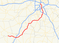
State Route 54 (SR 54) is a 70.5-mile-long (113.5 km) state highway that runs southwest-to-northeast through portions of Troup, Meriwether, Coweta, Fayette, Clayton, and Fulton counties in the northwestern part of the U.S. state of Georgia. The route connects Hogansville with Atlanta, via Peachtree City, Fayetteville, Jonesboro, and Forest Park.
Route description
SR 54 begins at an intersection with US 27/SR 1 (New Franklin Road) west of Hogansville, in north-central Troup County. It heads east into town, where it intersects US 29/SR 14/SR 100 (Hogansville Road). SR 54/SR 100 head to the southeast concurrently. Just before leaving the county, the highway has an interchange with Interstate 85 (I-85). Then, the two highways split before crossing into Meriwether County. SR 54 heads east-northeast, and curves to the northeast, until it enters Luthersville. There, it intersects US 27 Alternate/SR 41 (Roosevelt Highway), before meeting the northern terminus of SR 54 Spur (Park Street). At this intersection, SR 54 turns to the north and crosses into Coweta County. It heads northeast, through rural areas of the county and intersects SR 16 in Turin. Almost immediately after, it enters Sharpsburg, where it meets the southern terminus of SR 154 (Sharpsburg McCollum Road). Northeast of Sharpsburg, SR 54 has an intersection with SR 34 (Col. Joe M. Jackson Medal of Honor Highway). The highway heads to the east, crossing over Line Creek into Fayette County and Peachtree City. It curves to the northeast and intersects SR 74 (Joel Cowan Parkway). SR 54 curves to the east into Fayetteville, where it intersects SR 85/SR 92 (Glynn Street). To the northeast, it passes McCurry Park North and Links Golf Club, before crossing into Clayton County. In Jonesboro, it intersects US 19/US 41/SR 3 (Tara Boulevard). The four highways head concurrent to the north, along the western edge of Jonesboro. Just before the concurrency ends, they intersect SR 138 Spur (North Avenue). Slightly farther to the north-northwest is an intersection with SR 138. At this intersection, SR 54/SR 138 head east, just north of the city limits. At Jonesboro Road, SR 54 splits off to the north-northeast and enters Morrow. There, it passes Southlake Mall and has an interchange with I-75. Slightly south of the northern limits of town, it passes Clayton State University and curves to the north-northwest into Lake City. There, it meets the eastern terminus of SR 331 (Forest Parkway). In Forest Park, the highway skirts along the southwestern edge of Fort Gillem and meets the southern terminus of SR 54 Connector (Thurman Road). SR 54 enters Fulton County, and thus Atlanta, approximately 2,000 feet (610 m) before it has an interchange with I-285. It passes Southside Park, the largest part in the city, before curving to the north-northeast and passing Browns Mill Golf Course. After that, it curves back to the northwest and passes Southview Cemetery, just before meeting the southern terminus of SR 54 Connector (Sawtell Avenue SE). Less than 1 mile (1.6 km) later, it meets the western terminus of SR 42 Spur (McDonough Boulevard SE). Approximately 1,000 feet (300 m) later, it turns to the southwest. Then, it curves back to the northwest to meet its northern terminus, an interchange with I-75/I-85 (Downtown Connector) in Downtown Atlanta.[1]
All of SR 54, from the Coweta–Fayette county line to the northern end of its concurrency with SR 138 northeast of Jonesboro, is included as part of the National Highway System, a system of roadways important to the nation's economy, defense, and mobility.[2]
History
The southern end of SR 54 from US 27/SR 1 to Hogansville was previously numbered State Route 258 until 1963-1964.
Major interchanges
| County | Location | mi[1] | km | Destinations | Notes |
|---|---|---|---|---|---|
| Troup | | 0.0 | 0.0 | Southern terminus | |
| Hogansville | 7.4 | 11.9 | Southern end of SR 100 concurrency | ||
| | 10.3 | 16.6 | I-85, exit 28 | ||
| | 10.7 | 17.2 | Northern end of SR 100 concurrency | ||
| Meriwether | Luthersville | 18.6 | 29.9 | ||
| 18.7 | 30.1 | Northern terminus of SR 54 Spur | |||
| Coweta | Turin | 29.9 | 48.1 | ||
| Sharpsburg | 30.7 | 49.4 | Southern terminus of SR 154 | ||
| | 35.0 | 56.3 | Eastern terminus of SR 34 | ||
| Line Creek | 35.5 | 57.1 | Unnamed bridge over Line Creek, marking the Coweta–Fayette county line | ||
| Fayette | Peachtree City | 36.6 | 58.9 | ||
| Lake Peachtree | 37.4 | 60.2 | Unnamed bridge | Crossing over Lake Peachtree | |
| Fayetteville | 46.2 | 74.4 | |||
| Camp Creek | 50.8 | 81.8 | Unnamed bridge over Camp Creek, marking the Fayette–Clayton county line | ||
| Clayton | Jonesboro | 53.7 | 86.4 | Southern end of US 19/US 41/SR 3 concurrency | |
| 55.0 | 88.5 | ||||
| | 55.4 | 89.2 | Northern end of US 19/US 41/SR 3 concurrency; western end of SR 138 concurrency | ||
| | 56.2 | 90.4 | Eastern end of SR 138 concurrency | ||
| Morrow | 58.8 | 94.6 | I-75, exit 233 | ||
| Lake City | 61.7 | 99.3 | Eastern terminus of SR 331 | ||
| Forest Park | 63.2 | 101.7 | Southern terminus of SR 54 Connector | ||
| Fulton | Atlanta | 64.4 | 103.6 | I-285, exit 55 | |
| 66.8 | 107.5 | Unnamed bridge | Crossing over the South River | ||
| 68.7 | 110.6 | Southern terminus of SR 54 Connector | |||
| 69.8 | 112.3 | Northern terminus of SR 42 Spur | |||
| 70.5 | 113.5 | Northern terminus; I-75/I-85, exit 244 | |||
1.000 mi = 1.609 km; 1.000 km = 0.621 mi
| |||||
Bannered routes
Atlanta connector route
| |
|---|---|
| Location: | Southeast Atlanta |
| Length: | 0.7 mi[3] (1.1 km) |
State Route 54 Connector (SR 54 Connector) is a 0.7-mile-long (1.1 km) connector route that exists entirely within the southeastern part of Fulton County. Its routing is completely within the city limits of Atlanta.
It begins at an intersection with the SR 54 mainline, northwest of Southview Cemetery. It heads northeast, before curving to a due-north orientation. The highway passes along the western edge of United States Penitentiary, Atlanta, before a slight jog to the northeast right before its northern terminus, an intersection with SR 42 Spur.[3]
SR 54 Connector is not part of the National Highway System, a system of roadways important to the nation's economy, defense, and mobility.[2]
The entire route is in Atlanta, Fulton County.
| mi[3] | km | Destinations | Notes | ||
|---|---|---|---|---|---|
| 0.0 | 0.0 | Southern terminus | |||
| 0.7 | 1.1 | Northern terminus | |||
| 1.000 mi = 1.609 km; 1.000 km = 0.621 mi | |||||
Clayton–Fulton County connector route
| |
|---|---|
| Location: | Forest Park–Atlanta |
| Length: | 2.2 mi[4] (3.5 km) |
State Route 54 Connector (SR 54 Connector) is a 2.2-mile-long (3.5 km) connector route that exists within portions of Clayton and Fulton counties of the U.S. state of Georgia.
It begins at an intersection with the SR 54 mainline (Jonesboro Road). It heads northeast into the southeastern portion of Atlanta and meets its northern terminus, an intersection with US 23/SR 42 (Moreland Avenue).[4]
SR 54 Connector is not part of the National Highway System, a system of roadways important to the nation's economy, defense, and mobility.[2]
| County | Location | mi[1] | km | Destinations | Notes |
|---|---|---|---|---|---|
| Clayton | Forest Park | 0.0 | 0.0 | Southern terminus | |
| Fulton | Atlanta | 2.2 | 3.5 | Northern terminus; no access for US 23/SR 42 north to SR 54 Connector south, or for SR 54 Connector north to US 23/SR 42 north | |
| 1.000 mi = 1.609 km; 1.000 km = 0.621 mi | |||||
Spur route
| |
|---|---|
| Location: | Luthersville |
| Length: | 0.2 mi[5] (0.3 km) |
State Route 54 Spur (SR 54 Spur) also known as Park Street, is a 0.2-mile-long (0.32 km) spur route that is location completely within Luthersville.
It begins at an intersection with US 27 Alternate/SR 41 (Roosevelt Highway) and heads north-northeast for one block. There, it meets its northern terminus, an intersection with the SR 54 mainline (East Oak Street). The highway eases the transition of southbound SR 54 to southbound US 27 Alternate/SR 41 or northbound on US 27 Alternate/SR 41 to northbound SR 54. The southern terminus is a Y-type intersection. Its northern terminus meets SR 54 (East Oak Street) southbound to its left, SR 54 (Park Street) eastbound straight ahead, and the continuation of East Oak Street to its right.[5]
SR 54 Spur is not part of the National Highway System, a system of roadways important to the nation's economy, defense, and mobility.[2]
The entire route is in Luthersville, Meriwether County.
| mi[1] | km | Destinations | Notes | ||
|---|---|---|---|---|---|
| 0.0 | 0.0 | Southern terminus | |||
| 0.2 | 0.32 | Northern terminus | |||
| 1.000 mi = 1.609 km; 1.000 km = 0.621 mi | |||||
See also
-
.svg.png) Georgia (U.S. state) portal
Georgia (U.S. state) portal -
 Atlanta portal
 -
 U.S. Roads portal
 - Transportation in Atlanta
References
- 1 2 3 4 5 Google (August 5, 2013). "Route of SR 54 (Southern terminus to McDonough Boulevard SE)" (Map). Google Maps. Google. Retrieved August 5, 2013.
Google (August 5, 2013). "Route of SR 54 (McDonough Boulevard SE to northern terminus)" (Map). Google Maps. Google. Retrieved August 5, 2013. - 1 2 3 4 "National Highway System: Georgia" (PDF). United States Department of Transportation. October 1, 2012. Retrieved August 5, 2013.
- 1 2 3 Google (August 5, 2013). "Route of SR 54 Connector (Atlanta)" (Map). Google Maps. Google. Retrieved August 5, 2013.
- 1 2 Google (August 5, 2013). "Route of SR 54 Connector (Clayton–Fulton County)" (Map). Google Maps. Google. Retrieved August 5, 2013.
- 1 2 Google (August 5, 2013). "Route of SR 54 Spur" (Map). Google Maps. Google. Retrieved August 5, 2013.
External links
-
 Media related to Georgia State Route 54 at Wikimedia Commons
 - Georgia Roads (Routes 41 - 60)
- Georgia State Route 54 CONN on State-Ends.com
- Georgia Routes 241-260