Georgia State Route 16
| ||||
|---|---|---|---|---|
 | ||||
| Route information | ||||
| Maintained by GDOT | ||||
| Length: | 178.0 mi[1] (286.5 km) | |||
| Major junctions | ||||
| West end: |
| |||
|
| ||||
| East end: |
| |||
| Location | ||||
| Counties: | Haralson, Carroll, Coweta, Spalding, Butts, Jasper, Putnam, Hancock, Warren | |||
| Highway system | ||||
| ||||

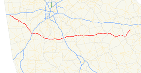
State Route 16 (SR 16) is a 178-mile-long (286 km) state highway that runs west-to-east through portions of Haralson, Carroll, Coweta, Spalding, Butts, Jasper, Putnam, Hancock, and Warren counties in the western and central parts of the U.S. state of Georgia. The route connects the southeastern portion of Carroll County, northwest of Mount Zion to Warrenton, via Carrollton, Newnan, Griffin, Monticello, Eatonton, and Sparta.
Route description
The route starts just south of I-20 in southwestern Haralson County, and runs southeast into Carroll County and Carrollton, where it begins a concurrence with US 27. SR 16 continues through Whitesburg and crosses into Coweta County and through Newnan, where its overlap with US 27 ends, crossing I-85 just east of Newnan.
Turning sharply east, the route runs through Sharpsburg, turns slightly southeast, and travels through Senoia into Spalding County, turning back east, and running into Griffin. Turning slightly northeast, SR 16 crosses I-75 at the county line with Butts County and runs into and through Jackson on into Monticello in Jasper County.
Continuing east, the route crosses into Putnam County, through Eatonton, then turns southeast at the county line with Hancock County, heading on into Sparta. Turning first slightly northeast, then southeast, SR 16 continues into Warren County, where it turns northeast once more and on to its eastern terminus in Warrenton.
There are two sections of SR 16 that are included as part of the National Highway System, a system of roadways important to the nation's economy, defense, and mobility:
- Approximately 5 miles (8.0 km) in Carrollton, most of it concurrent with US 27/SR 1 and SR 166
- From US 19/US 41/SR 3 in Griffin east to I-75, approximately 7 miles (11 km) south-southeast of Locust Grove[2]
History
Major intersections
| County | Location | mi | km | Destinations | Notes |
|---|---|---|---|---|---|
| Haralson | | 0.00 | 0.00 | ||
| Carroll | Carrollton | west end of US 27 / SR 1 overlap | |||
| South Street - Historic Downtown | interchange | ||||
| east end of US 27 / SR 1 overlap; west end of US 27 Alt. / SR 166 overlap | |||||
| east end of SR 166 overlap | |||||
| Whitesburg | roundabout | ||||
| Coweta | | ||||
| Newnan | west end of SR 34 overlap | ||||
| west end of US 29 / SR 14 overlap | |||||
| east end of SR 34 overlap | |||||
| east end of US 27 Alt. / US 29 / SR 14 overlap | |||||
| Turin | |||||
| Senoia | |||||
| Spalding | Griffin | interchange | |||
| west end of US 19 Bus. / US 41 Bus. overlap | |||||
| east end of US 19 Bus. / US 41 Bus. overlap | |||||
| Butts | | I-75 exit 205 | |||
| Jackson | west end of US 23 / SR 42 overlap | ||||
| west end of SR 36 overlap | |||||
| east end of SR 36 overlap | |||||
| east end of US 23 / SR 42 overlap | |||||
| Jasper | Monticello | west end of SR 212 overlap | |||
| traffic circle around the town square | |||||
| | east end of SR 212 overlap | ||||
| | |||||
| Putnam | Willard | ||||
| Eatonton | |||||
| west end of US 129 Bus. / US 441 Bus. / SR 24 Bus. overlap | |||||
| east end of US 129 Bus. / US 441 Bus. / SR 24 Bus. overlap; west end of SR 44 overlap | |||||
| east end of SR 44 overlap | |||||
| Hancock | | ||||
| | west end of SR 15 / SR 22 overlap | ||||
| Sparta | east end of SR 22 overlap | ||||
| east end of SR 15 overlap | |||||
| Warren | | ||||
| Warrenton | |||||
| Eastern terminus | |||||
1.000 mi = 1.609 km; 1.000 km = 0.621 mi
| |||||
See also
-
.svg.png) Georgia (U.S. state) portal
Georgia (U.S. state) portal -
 U.S. Roads portal
References
- ↑ Google (August 24, 2013). "Route of SR 16" (Map). Google Maps. Google. Retrieved August 24, 2013.
- ↑ "National Highway System: Georgia" (PDF). United States Department of Transportation. October 1, 2012. Retrieved September 5, 2013.
External links
-
 Media related to Georgia State Route 16 at Wikimedia Commons
 - Georgia Roads (Routes 1 - 20)