Georgia State Route 64
| ||||
|---|---|---|---|---|
 | ||||
| Route information | ||||
| Maintained by GDOT | ||||
| Length: | 45.9 mi[1] (73.9 km) | |||
| Major junctions | ||||
| Southwest end: |
| |||
|
| ||||
| Northeast end: |
| |||
| Location | ||||
| Counties: | Berrien, Lanier, Atkinson, Coffee | |||
| Highway system | ||||
| ||||

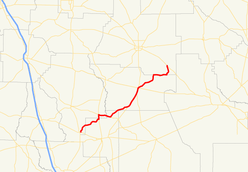
State Route 64 (SR 64) is a 45.9-mile-long (73.9 km) state highway that runs southwest-to-northeast through portions of Berrien, Lanier, Atkinson, and Coffee counties in the south-central part of the U.S. state of Georgia. The route connects Ray City with Wilsonville.
Route description
SR 64 begins at an intersection with US 129/SR 11/SR 37 in Ray City. It heads to the north-northeast, through rural areas of Berrien County. The road then enters Lanier County. It begins a concurrency with SR 135 just before crossing back into Berrien County. Less than 2 miles (3.2 km) after crossing the county line, they intersect SR 168. SR 64 and SR 168 run concurrent to the east. The two routes cross over the Alapaha River back into Lanier County. Less than 2 miles (3.2 km) later, SR 64 then departs from the concurrency to the northeast and goes through rural areas of the county before it enters Atkinson County. A short distance into the county, it intersects US 221/SR 31. The three routes head concurrent to the northeast. Just before entering Pearson, US 441/SR 89 intersect the concurrency, with US 441 joining it. In Pearson, the four highways intersect US 82/SR 520. SR 64 turns to the right onto US 82/SR 520. The three highways have a very brief concurrency to the east-southeast. The road splits off to the northeast and runs along the Atkinson–Coffee county line. A short distance later, it slips back into Atkinson County proper for about 2 miles (3.2 km) and then runs along the county line again. SR 64 heads to the north for a few miles before meeting its northern terminus, an intersection with SR 158 in Wilsonville. Interestingly, its true northern terminus is actually in Bacon County, ending as Stock Market Road as it hits GA 32 in Alma, GA. For some reason, the road has a gap; having never been completed to link up with its southern leg. The road ends in Bacon county.
SR 64 is not part of the National Highway System, a system of roadways important to the nation's economy, defense, and mobility.[2]
Major intersections
| County | Location | mi[1] | km | Destinations | Notes | |||
|---|---|---|---|---|---|---|---|---|
| Berrien | Ray City | 0.0 | 0.0 | Southern terminus | ||||
| Lanier | | 8.8 | 14.2 | Southern end of SR 135 concurrency | ||||
| Berrien | | 10.4 | 16.7 | Southern end of SR 135 concurrency; northern end of SR 168 concurrency | ||||
| Alapaha River | 13.3 | 21.4 | Unnamed bridge over the Alapaha River, marking the Berrien–Lanier county line | |||||
| Lanier | | 14.7 | 23.7 | Northern end of SR 168 concurrency | ||||
| Atkinson | | 22.1 | 35.6 | Southern end of US 221/SR 31 concurrency | ||||
| | 27.9 | 44.9 | Southern end of US 441 concurrency;northern terminus of SR 89 | |||||
| Pearson | 29.8 | 48.0 | Northern end of US 221/US 441/SR 31 concurrency; southern end of US 82/SR 520 concurrency | |||||
| 29.9 | 48.1 | Northern end of US 82/SR 520 concurrency | ||||||
| Satilla River | 35.7 | 57.5 | Unnamed bridge | Crossing over the Satilla River | ||||
| Atkinson–Coffee |
No major junctions | |||||||
| Atkinson |
No major junctions | |||||||
| Atkinson–Coffee |
No major junctions | |||||||
| Coffee | Wilsonville | 45.9 | 73.9 | Northern terminus | ||||
1.000 mi = 1.609 km; 1.000 km = 0.621 mi
| ||||||||
See also
-
.svg.png) Georgia (U.S. state) portal
Georgia (U.S. state) portal -
 U.S. Roads portal
References
- 1 2 Google (July 30, 2013). "Route of SR 64" (Map). Google Maps. Google. Retrieved July 30, 2013.
- ↑ "National Highway System: Georgia" (PDF). United States Department of Transportation. October 1, 2012. Retrieved July 30, 2013.
External links
-
 Media related to Georgia State Route 64 at Wikimedia Commons
 - Georgia Roads (Routes 61 - 80)