Waycross, Georgia
| Waycross, Georgia | |
|---|---|
| City | |
|
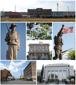
Images from top, left to right: Downtown Waycross, Confederate memorial, alligator in the Okefenokee Swamp, Waycross City Hall, World War I memorial, Downtown Waycross Historic District, Ware County Courthouse | |
| Motto: Headwaters of the Okefenokee | |
 Location in Ware County and the state of Georgia | |
| Coordinates: 31°12′50″N 82°21′18″W / 31.21389°N 82.35500°WCoordinates: 31°12′50″N 82°21′18″W / 31.21389°N 82.35500°W | |
| Country | United States |
| State | Georgia |
| Counties | Ware[1] |
| Government | |
| • Mayor | John Knox |
| Area | |
| • Total | 11.7 sq mi (30.3 km2) |
| • Land | 11.7 sq mi (30.3 km2) |
| • Water | 0.0 sq mi (0.1 km2) |
| Elevation | 131 ft (40 m) |
| Population (2010) | |
| • Total | 14,725 |
| • Density | 1,258.6/sq mi (485.9/km2) |
| Time zone | EST (UTC-5) |
| • Summer (DST) | EDT (UTC-4) |
| ZIP codes | 31501-31502-31503 |
| Area code(s) | 912 |
| FIPS code | 13-80956[2] |
| GNIS feature ID | 0356622[3] |
| Website | http://www.waycrossga.com |
Waycross is the county seat of, and only incorporated city in, Ware County. in the U.S. state of Georgia. The population was 14,725 at the 2010 Census.
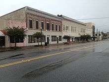
Waycross includes two historic districts (Downtown Waycross Historic District and Waycross Historic District) and several other properties that are on the National Register of Historic Places, including the U.S. Post Office and Courthouse, Lott Cemetery, the First African Baptist Church and Parsonage, and the Obediah Barber Homestead (which is seven miles south of the city).
History
The area now known as Waycross was first settled around 1820, locally known as "Old Nine" or "Number Nine" and then Pendleton. It was renamed Tebeauville in 1857, incorporated in 1866, and designated county seat of Ware County in 1873. Then it was incorporated as "Way Cross" on March 3, 1935.[4]
Waycross was the site of the 1948 Waycross B-29 crash, which led to the legal case United States v. Reynolds (1953), expanding the government's state secrets privilege.
During the 1950s the city had a tourist gimmick: local police would stop motorists with out-of-state license plates and escort them to downtown Waycross. There they would be met by the Welcome World Committee and given overnight lodging, dinner and a trip to the Okefenokee Swamp. The tradition faded away after the interstates opened through Georgia.
During the mid-1990s, Waycross originated a frozen hamburger that needed no defrosting, the Bubba Burger.[5] This was the creation of Eaves Foods, Inc., a company that later changed to Bubba Foods, LLC. in 2000. Bubba Burgers are now sold nationwide as well as worldwide through the United States Military Commissary system.[6]
Geography
Waycross is located at 31°12′50″N 82°21′18″W / 31.21389°N 82.35500°W (31.213860, -82.354911)[7] and is the closest city to the Okefenokee Swamp.
According to the United States Census Bureau, the city has a total area of 11.7 square miles (30 km2), of which 11.7 square miles (30 km2) is land and 0.04 square miles (0.10 km2) (0.17%) is water. It is 198 miles east of Dothan, Alabama and 40 miles west of Jesup.
In May 2010, the city purchased the Bandalong Litter Trap and installed it in Tebeau Creek, a tributary of the Satilla River. The trap was invented in Australia, but is manufactured in the United States. Although the city has maintained a good standing with the state's Environmental Protection Division, the city wanted to take action to reduce the amount of human generated trash entering the Satilla River and ultimately the Atlantic Ocean. Georgia Governor Sonny Perdue said, “Water is one of Georgia’s most important and precious resources... the litter trap installed by Waycross is a model of stewardship for the state and the nation.” The Satilla River litter trap is the first in Georgia and only the second in the nation.[8]
Part of Waycross was situated in Pierce County, but effective July 1, 2015, Waycross was no longer located nor allowed to be located in Pierce County. State Rep. Chad Nimmer[9] introduced HB 523 during the 2015 Legislative Session without providing the required statutory notice to the City of Waycross. HB 523 de-annexed the portion of Waycross located in Pierce County and prevents the City of Waycross from coming back into Pierce County.[10]
Climate
| Climate data for Waycross 4NE (1981-2010) extremes 1897–present | |||||||||||||
|---|---|---|---|---|---|---|---|---|---|---|---|---|---|
| Month | Jan | Feb | Mar | Apr | May | Jun | Jul | Aug | Sep | Oct | Nov | Dec | Year |
| Record high °F (°C) | 88 (31) |
88 (31) |
95 (35) |
98 (37) |
104 (40) |
106 (41) |
108 (42) |
106 (41) |
104 (40) |
99 (37) |
92 (33) |
87 (31) |
108 (42) |
| Average high °F (°C) | 62.2 (16.8) |
65.9 (18.8) |
72.9 (22.7) |
79.2 (26.2) |
86.4 (30.2) |
90.9 (32.7) |
92.9 (33.8) |
91.2 (32.9) |
87.3 (30.7) |
79.7 (26.5) |
72.7 (22.6) |
64.0 (17.8) |
78.8 (26) |
| Daily mean °F (°C) | 48.9 (9.4) |
52.5 (11.4) |
58.9 (14.9) |
64.7 (18.2) |
72.8 (22.7) |
79.3 (26.3) |
81.8 (27.7) |
80.8 (27.1) |
76.2 (24.6) |
66.9 (19.4) |
58.9 (14.9) |
50.8 (10.4) |
66.0 (18.9) |
| Average low °F (°C) | 35.7 (2.1) |
39.0 (3.9) |
44.9 (7.2) |
50.2 (10.1) |
59.1 (15.1) |
67.7 (19.8) |
70.8 (21.6) |
70.4 (21.3) |
65.0 (18.3) |
54.1 (12.3) |
45.2 (7.3) |
37.6 (3.1) |
53.3 (11.8) |
| Record low °F (°C) | 2 (−17) |
2 (−17) |
15 (−9) |
22 (−6) |
33 (1) |
43 (6) |
54 (12) |
57 (14) |
34 (1) |
22 (−6) |
18 (−8) |
8 (−13) |
2 (−17) |
| Average precipitation inches (mm) | 4.34 (110.2) |
3.89 (98.8) |
4.49 (114) |
2.89 (73.4) |
2.80 (71.1) |
6.51 (165.4) |
5.91 (150.1) |
6.39 (162.3) |
4.16 (105.7) |
3.25 (82.6) |
2.46 (62.5) |
2.96 (75.2) |
50.05 (1,271.3) |
| Average precipitation days (≥ 0.01 in) | 9.0 | 8.0 | 8.0 | 6.0 | 7.0 | 11.0 | 12.0 | 12.0 | 8.0 | 6.0 | 7.0 | 8.0 | 102 |
| Source: NOAA [11] | |||||||||||||
Media
- Waycross Journal-Herald [12](daily newspaper)
- The Florida Times-Union (Georgia Times-Union edition)
- Waycross Area Television Service (WATS) Channel 10[13]
- AM
- FM
- W201DK 88.1 (Christian)
- WXVS 90.1 (GPB and NPR)
- WASW 91.9 (Contemporary Christian)
- WAYX 96.3 (Classic Rock) Simulcast with WSIZ
- WWUF 97.7 (Adult Contemporary)
- WYNR 102.5 (Country)
- WWSN 103.3 (Adult Contemporary)
- WKUB 105.1 (Country)
- WSGT 107.1 (Oldies)
Health care

With over 1,000 employees and 100 physicians, Satilla Regional Medical Center is a leading center in health care in the area. The three-story facility has a trauma unit, cancer care unit, outpatient surgery and imaging services. In 2012, Satilla Regional Medical Center joined the Mayo Clinic Health System and became the Mayo Clinic Health System in Waycross.[14]
Transportation
U.S. Highway 1 runs north-south through Waycross. U.S. Highway 82 is an east-west highway in Waycross. U.S. Highway 84 runs east-west through Waycross. Waycross-Ware County Airport (IATA: AYS, ICAO: KAYS, FAA LID: AYS) is a public airport located three miles (5 km) northwest of the central business district of Waycross. It is owned by the City of Waycross and Ware County.
Six railroad lines meet at Waycross, making it a logical location for shunting freight to different destinations. CSX Transportation operates Rice Yard here, a major "hump"-type classification yard.
Demographics
| Historical population | |||
|---|---|---|---|
| Census | Pop. | %± | |
| 1880 | 628 | — | |
| 1890 | 3,364 | 435.7% | |
| 1900 | 5,919 | 76.0% | |
| 1910 | 14,485 | 144.7% | |
| 1920 | 18,068 | 24.7% | |
| 1930 | 15,510 | −14.2% | |
| 1940 | 16,763 | 8.1% | |
| 1950 | 18,899 | 12.7% | |
| 1960 | 20,944 | 10.8% | |
| 1970 | 18,996 | −9.3% | |
| 1980 | 19,371 | 2.0% | |
| 1990 | 16,410 | −15.3% | |
| 2000 | 15,333 | −6.6% | |
| 2010 | 14,649 | −4.5% | |
| Est. 2015 | 14,053 | [15] | −4.1% |
As of the 2010 United States Census, there were 14,649 people residing in the city. The racial makeup of the city was 54.8% Black, 39.6% White, 0.3% Native American, 0.8% Asian, 0.0% Pacific Islander, 0.2% from some other race and 1.5% from two or more races. 2.8% were Hispanic or Latino of any race.
As of the census[2] of 2000, there were 15,333 people, 6,094 households, and 3,741 families residing in the city. The population density was 1,311.8 people per square mile (506.4/km²). There were 7,534 housing units at an average density of 644.5 per square mile (248.8/km²). The racial makeup of the city was 44.31% White, 53.51% African American, 0.12% Native American, 0.62% Asian, 0.02% Pacific Islander, 0.68% from other races, and 0.74% from two or more races. Hispanic or Latino of any race were 1.37% of the population.
There were 6,094 households, out of which 27.7% had children under the age of 18 living with them, 36.3% were married couples living together, 21.0% had a female householder with no husband present, and 38.6% were non-families. Individuals made up 34.9% of all households, and 16.0% had someone living alone who was 65 years of age or older. The average household size was 2.37, and the average family size was 3.09.
In the city the population was spread out, with 26.3% under the age of 18, 8.5% from 18 to 24, 25.2% from 25 to 44, 20.5% from 45 to 64, and 19.5% who were 65 years of age or older. The median age was 37 years. For every 100 females there were 83.9 males. For every 100 females age 18 and over, there were 76.9 males.
The median income for a household in the city was $23,399, and the median income for a family was $28,712. Males had a median income of $24,865 versus $18,750 for females. The per capita income for the city was $13,468. About 24.8% of families and 30.4% of the population were below the poverty line, including 45.9% of those under age 18 and 17.0% of those age 65 or over.
Education
Ware County School District
The Ware County School District holds pre-school to grade twelve, and consists of a pre-school, six elementary schools, two middle schools, and one high school.[17] The district has 431 full-time teachers and over 6,370 students.[18]
Private education
- Southside Christian School[19]
Higher education
- South Georgia State College - Waycross campus[20]
- Coastal Pines Technical College - Waycross campus[21]
Famous natives and residents
- Arthur Albertson — film actor, star of 50 silent films from 1914 to 1917
- Johnny Archer — professional pool player, "The Scorpion"
- Michael P. Boggs — judge on the Georgia Court of Appeals.
- Stanley Booth — author, journalist, music critic
- Billy Carter — brother of former President Jimmy Carter, promoter of Billy Beer
- Sonora Webster Carver — first woman horse diver
- Bill Darden — founder of The Green Frog and Red Lobster; namesake of Darden Restaurants, which has owned Red Lobster, Olive Garden, Bahama Breeze, Seasons 52, LongHorn Steakhouse and The Capital Grille
- Ossie Davis — actor, writer, director, producer, Kennedy Center Honors award recipient, was born in Clinch County
- Nikki DeLoach — former member of The New Mickey Mouse Club, the girl group Innosense, and actress on the television series North Shore and Windfall
- Harry D. Dixon — state representative; served in the Georgia House of Representatives for 38 years; served on the board of the Georgia Department of Transportation
- Drayton Florence — professional football player, cornerback who played 11 seasons in NFL, highest draft pick ever from Tuskegee University
- Tim McCray — professional football player from 1985 to 1990 in the CFL
- Leodis McKelvin — cornerback for the NFL's Buffalo Bills
- Caroline Pafford Miller — Pulitzer Prize-winning author
- Gram Parsons — country singer and musician; The Byrds, The Flying Burrito Brothers, and solo artist
- Pernell Roberts — actor, star of TV series Bonanza and Trapper John, M.D., was born in Waycross
- Bill Shanks — Atlanta Braves sportscaster
- Brenda Scott Wilkinson — author
See also
On the National Register of Historic Places:
- First African Baptist Church and Parsonage
- Lott Cemetery
- Phoenix Hotel
- United States Post Office and Courthouse
References
- ↑ U.S. Census Bureau. Census 2000, Summary File 1. "GCT-PH1. Population, Housing Units, Area, and Density: 2000 - County -- Subdivision and Place". American FactFinder. <http://factfinder2.census.gov>. Retrieved 2008-01-31.
- 1 2 "American FactFinder". United States Census Bureau. Retrieved 2008-01-31.
- ↑ "US Board on Geographic Names". United States Geological Survey. 2007-10-25. Retrieved 2008-01-31.
- ↑ Ware County Courthouse entry on GeorgiaInfo.com Ware County Courthouse, Carl Vinson Institute of Government, 2008. Retrieved 2008-07-16.
- ↑ Frozen Burgers Make a Big Splash Across the South, The Augusta Chronicle. Retrieved 2013-10-08.
- ↑ , Bubba Burger Heritage. Retrieved 2013-10-08.
- ↑ "US Gazetteer files: 2010, 2000, and 1990". United States Census Bureau. 2011-02-12. Retrieved 2011-04-23.
- ↑ "Georgia's First Bandalong Litter Trap Launched". Storm Water Solutions Magazine. May 26, 2010. Retrieved 7 April 2014.
- ↑ http://www.house.ga.gov/Representatives/en-US/member.aspx?Member=790&Session=24
- ↑ http://www.legis.ga.gov/Legislation/20152016/151607.pdf
- ↑ "NOWData - NOAA Online Weather Data". NOAA. Retrieved 2016-04-01.
- ↑ Waycross Journal-Herald
- ↑ aycross Area Television Service (WATS) Channel 10
- ↑ Mayo Clinic Health System in Waycross
- ↑ "Annual Estimates of the Resident Population for Incorporated Places: April 1, 2010 to July 1, 2015". Retrieved July 2, 2016.
- ↑ "Census of Population and Housing". Census.gov. Retrieved June 4, 2015.
- ↑ Georgia Board of Education, Retrieved June 29, 2010.
- ↑ School Stats, Retrieved June 29, 2010.
- ↑ Southside Christian School
- ↑ South Georgia State College
- ↑ Coastal Pines Technical College
External links
| Wikivoyage has a travel guide for Waycross. |
- City of Waycross
- Waycross Local community website with community events calendar
- Waycross Tourism & Conference Bureau
- Historic Waycross
- South Georgia Historic Newspapers Archive, Digital Library of Georgia
Municipalities and communities of Ware County, Georgia, United States | ||
|---|---|---|
| City | 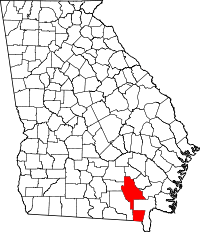 | |
| CDPs | ||
| Unincorporated communities | ||
| Footnotes | ‡This populated place also has portions in an adjacent county or counties | |