Georgia State Route 76
| ||||
|---|---|---|---|---|
 | ||||
| Route information | ||||
| Maintained by GDOT | ||||
| Length: | 62.2 mi[1] (100.1 km) | |||
| Major junctions | ||||
| South end: |
| |||
| North end: |
| |||
| Location | ||||
| Counties: | Brooks, Cook, Berrien | |||
| Highway system | ||||
| ||||

State Route 76 (SR 76) is a state highway in Georgia.
Route description
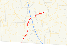
Starting at the Florida line south of Quitman in Brooks County,[2] SR 76 heads north concurrent with U.S. Route 221 (US 221). Just south of Quitman, both roads merge with SR 333. In downtown Quitman, US 221 heads east, and SR 76/SR 333 stays concurrent. Just north of downtown, SR 76 splits off from SR 333. It then passes through the towns of Morven and Barney before entering Cook County.[3]
SR 76 enters Cook County southwest of Adel. In town, it crosses, but does not junction with, Interstate 75 (I-75). In downtown, SR 76 runs concurrent with SR 37. They split east of Adel, and SR 76 heads northeast into Berrien County.[4]
SR 76 enters Berrien County southwest of Nashville. Reaching downtown Nashville, it runs concurrently with US 129, SR 11, and SR 125 for a short distance. After splitting off, SR 76 heads east, jogs north, and then heads east until it terminates at SR 135.[5][6]
Major intersections
| County | Location | mi | km | Destinations | Notes |
|---|---|---|---|---|---|
| Brooks | | 0.0 | 0.0 | Florida state line | |
| Quitman | 10.1 | 16.3 | West end of SR 333 overlap | ||
| 10.9 | 17.5 | South end of US 84 / SR 38 overlap | |||
| 11.1 | 17.9 | East end of US 84 / US 221 / SR 38 overlap | |||
| East end of SR 333 overlap | |||||
| Morven | 23.3 | 37.5 | |||
| Barney | 27.8 | 44.7 | |||
| Cook | Adel | 38.0 | 61.2 | West end of SR 37 overlap | |
| 38.6 | 62.1 | ||||
| | 40.5 | 65.2 | East end of SR 37 overlap | ||
| Berrien | Nashville | 50.8 | 81.8 | West end of US 129 / SR 11 / SR 125 overlap | |
| 51.5 | 82.9 | ||||
| 51.6 | 83.0 | East end of US 129 / SR 11 / SR 125 overlap | |||
| | 62.2 | 100.1 | |||
1.000 mi = 1.609 km; 1.000 km = 0.621 mi
| |||||
See also
-
.svg.png) Georgia (U.S. state) portal
Georgia (U.S. state) portal -
 U.S. Roads portal
References
- ↑ Google (December 9, 2011). "Overview Map of SR 76" (Map). Google Maps. Google. Retrieved December 9, 2011.
- ↑ Google (December 8, 2011). "Quitman, GA" (Map). Google Maps. Google. Retrieved December 8, 2011.
- ↑ Functional Classification Map: Brooks County, Georgia (PDF) (Map). Cartography by Office of Transportation Data. Georgia Department of Transportation. December 2010. Retrieved December 9, 2011.
- ↑ Functional Classification Map: Cook County, Georgia (PDF) (Map). Cartography by Office of Transportation Data. Georgia Department of Transportation. 2005. Retrieved December 9, 2011.
- ↑ Functional Classification Map: Berrien County, Georgia (PDF) (Map). Cartography by Office of Transportation Data. Georgia Department of Transportation. October 2009. Retrieved December 9, 2011.
- ↑ Google (December 8, 2011). "Nashville, GA" (Map). Google Maps. Google. Retrieved December 8, 2011.
External links
-
 Media related to Georgia State Route 76 at Wikimedia Commons