Geronimo, Arizona
| Geronimo, Arizona | |
|---|---|
| Populated place | |
 Geronimo  Geronimo Location within the state of Arizona | |
| Coordinates: 33°04′37″N 110°02′06″W / 33.07694°N 110.03500°WCoordinates: 33°04′37″N 110°02′06″W / 33.07694°N 110.03500°W | |
| Country | United States |
| State | Arizona |
| County | Graham |
| Elevation[1] | 2,723 ft (830 m) |
| Time zone | Mountain (MST) (UTC-7) |
| • Summer (DST) | MST (UTC-7) |
| Area code(s) | 928 |
| FIPS code | 04-26770 |
| GNIS feature ID | 24428 |
Geronimo is a populated place located on Highway 70 between Bylas and Fort Thomas west of Safford in Graham County, Arizona. Geronimo lies at an elevation of 2,723 feet (830 m).[1]
History
Geronimo was named after the famous Apache chief Goyaalé, better known as Geronimo. Camp Thomas, the U. S. Cavalry began its management of the Apache Indian Reservation along the Gila River, was originally located here in 1876. The camp was later moved east to what is now Fort Thomas. Geronimo was once a stop on the Arizona Eastern Railway and had an operating US Post Office from April 30, 1896 until May 31, 1956.[2]
References
Municipalities and communities of Graham County, Arizona, United States | ||
|---|---|---|
| City | 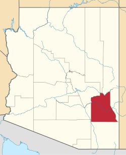 | |
| Towns | ||
| CDPs | ||
| Unincorporated communities | ||
| Indian reservations | ||
| Ghost towns | ||
| Footnotes | ‡This populated place also has portions in an adjacent county or counties | |
This article is issued from Wikipedia - version of the 11/21/2016. The text is available under the Creative Commons Attribution/Share Alike but additional terms may apply for the media files.