Gilford, New Hampshire
| Gilford, New Hampshire | ||
|---|---|---|
| Town | ||
|
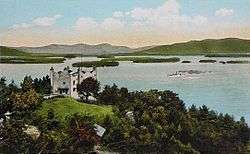
Kimball Castle and Lake Winnipesaukee c. 1920 | ||
| ||
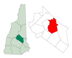 Location in Belknap County, New Hampshire | ||
| Coordinates: 43°32′51″N 71°24′26″W / 43.54750°N 71.40722°WCoordinates: 43°32′51″N 71°24′26″W / 43.54750°N 71.40722°W | ||
| Country | United States | |
| State | New Hampshire | |
| County | Belknap | |
| Incorporated | 1812 | |
| Government | ||
| • Board of Selectmen |
Richard Grenier, Chair Dale Chan Eddy Gus Benavides | |
| • Town Administrator | Scott Dunn | |
| Area | ||
| • Total | 53.7 sq mi (139.1 km2) | |
| • Land | 38.9 sq mi (100.7 km2) | |
| • Water | 14.8 sq mi (38.4 km2) 27.60% | |
| Elevation | 745 ft (227 m) | |
| Population (2010) | ||
| • Total | 7,126 | |
| • Density | 183/sq mi (70.8/km2) | |
| Time zone | Eastern (UTC-5) | |
| • Summer (DST) | Eastern (UTC-4) | |
| ZIP codes | 03247, 03249 | |
| Area code(s) | 603 | |
| FIPS code | 33-28740 | |
| GNIS feature ID | 0873603 | |
| Website |
www | |
Gilford is a town in Belknap County, New Hampshire, United States. The population was 7,126 at the 2010 census.[1] Situated on Lake Winnipesaukee, Gilford is home to Governors Island, Ellacoya State Beach, Belknap Mountain State Forest, Gunstock Mountain Ski Resort, and Bank of New Hampshire Pavilion at Meadowbrook, a seasonal outdoor concert venue.
History
Settled in 1778 and originally a part of Gilmanton, the town was first called Gunstock Parish. In 1812, Captain Lemuel B. Mason, who had fought in the 1781 Battle of Guilford Court House in North Carolina during the Revolutionary War and subsequently retired to Gunstock Parish, successfully proposed incorporation of a new town to be named Guilford after that battle. The name would later be contracted by clerical error. The original parish name is used by Gunstock Mountain and the ski resort located on it.[2]
Geography
According to the United States Census Bureau, the town has a total area of 53.7 square miles (139.1 km2), of which 38.9 sq mi (100.7 km2) is land and 14.8 sq mi (38.4 km2) is water, comprising 27.60% of the town. Belknap Mountain, elevation 2,384 feet (727 m) above sea level and the highest point in Gilford, is in the south. Much of the town is drained by the Gunstock River, a tributary of Lake Winnipesaukee. Gilford lies fully within the Merrimack River watershed.[3]
New Hampshire Route 11 crosses the town from east to west, connecting Alton and Rochester to the east with Laconia to the west. NH 11 joins U.S. Route 3 near the western border of Gilford, and together they turn south on the Laconia Bypass, which is largely within the Gilford town limits, traveling southwest towards Tilton and Franklin. New Hampshire Route 11A is an alternate east-west route to NH 11, passing through the center of Gilford and by the entrance to Gunstock Mountain Resort. New Hampshire Route 11B leaves NH 11 near Sanders Bay on Lake Winnipesaukee and proceeds northwest to Weirs Beach in Laconia.
Demographics
| Historical population | |||
|---|---|---|---|
| Census | Pop. | %± | |
| 1820 | 1,816 | — | |
| 1830 | 1,872 | 3.1% | |
| 1840 | 2,072 | 10.7% | |
| 1850 | 2,432 | 17.4% | |
| 1860 | 2,811 | 15.6% | |
| 1870 | 3,361 | 19.6% | |
| 1880 | 2,821 | −16.1% | |
| 1890 | 3,585 | 27.1% | |
| 1900 | 661 | −81.6% | |
| 1910 | 744 | 12.6% | |
| 1920 | 738 | −0.8% | |
| 1930 | 783 | 6.1% | |
| 1940 | 996 | 27.2% | |
| 1950 | 1,251 | 25.6% | |
| 1960 | 2,043 | 63.3% | |
| 1970 | 3,219 | 57.6% | |
| 1980 | 4,841 | 50.4% | |
| 1990 | 5,867 | 21.2% | |
| 2000 | 6,803 | 16.0% | |
| 2010 | 7,126 | 4.7% | |
| Est. 2015 | 7,167 | [4] | 0.6% |
As of the census[6] of 2000, there were 6,803 people, 2,766 households, and 2,019 families residing in the town. The population density was 174.6 people per square mile (67.4/km²). There were 4,312 housing units at an average density of 110.6 per square mile (42.7/km²). The racial makeup of the town was 98.32% White, 0.19% African American, 0.15% Native American, 0.51% Asian, 0.07% from other races, and 0.75% from two or more races. Hispanic or Latino of any race were 0.57% of the population.
There were 2,766 households out of which 30.8% had children under the age of 18 living with them, 61.9% were married couples living together, 8.1% had a female householder with no husband present, and 27.0% were non-families. 21.7% of all households were made up of individuals and 9.0% had someone living alone who was 65 years of age or older. The average household size was 2.46 and the average family size was 2.85.
In the town the population was spread out with 23.7% under the age of 18, 4.4% from 18 to 24, 25.4% from 25 to 44, 29.6% from 45 to 64, and 16.8% who were 65 years of age or older. The median age was 43 years. For every 100 females there were 92.0 males. For every 100 females age 18 and over, there were 89.8 males.
The median income for a household in the town was $48,658, and the median income for a family was $56,554. Males had a median income of $38,839 versus $27,325 for females. The per capita income for the town was $32,667. About 2.2% of families and 3.3% of the population were below the poverty line, including 1.2% of those under age 18 and 2.7% of those age 65 or over.
Sites of interest
- Bank of New Hampshire Pavilion at Meadowbrook
- John J. Morrill General Store (1857)
- Benjamin Rowe House (c. 1838)
- Union Meetinghouse (1834)
- Gunstock Mountain Resort
Notable people
- Glenn Cooper, internationally best-selling author and film producer
- Stilson Hutchins, newspaper reporter and publisher (The Washington Post)
- Megan Lyman, 2012 Miss New Hampshire
- Penny Pitou, first US woman to win an Olympic medal in downhill skiing
- Chris Sheridan, writer and television producer (Family Guy)
References
- ↑ United States Census Bureau, American FactFinder, 2010 Census figures. Retrieved March 23, 2011.
- ↑ Coolidge, Austin J.; John B. Mansfield (1859). A History and Description of New England. Boston, Massachusetts. p. 500.
- ↑ Foster, Debra H.; Batorfalvy, Tatianna N.; Medalie, Laura (1995). Water Use in New Hampshire: An Activities Guide for Teachers. U.S. Department of the Interior and U.S. Geological Survey.
- ↑ "Annual Estimates of the Resident Population for Incorporated Places: April 1, 2010 to July 1, 2015". Retrieved July 2, 2016.
- ↑ "Census of Population and Housing". Census.gov. Retrieved June 4, 2016.
- ↑ "American FactFinder". United States Census Bureau. Retrieved 2008-01-31.
External links
| Wikimedia Commons has media related to Gilford, New Hampshire. |
- Town of Gilford official website
- Gilford Public Library
- Gilford Police Department
- Thompson-Ames Historical Society
- Kimball Castle
- Varney Point Gilford NH Weather and Webcam view
- New Hampshire Economic and Labor Market Information Bureau Profile
Municipalities and communities of Belknap County, New Hampshire, United States | ||
|---|---|---|
| City | 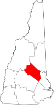 | |
| Towns | ||
| CDPs | ||
| Other villages | ||
| Footnotes | ‡This populated place also has portions in an adjacent county or counties | |