Gjógv
| Gjógv | |
|---|---|
| Village | |
|
Gjógv (2010) | |
 Gjógv Location in the Faroe Islands | |
| Coordinates: 62°19′30″N 6°56′28″W / 62.32500°N 6.94111°WCoordinates: 62°19′30″N 6°56′28″W / 62.32500°N 6.94111°W | |
| State |
|
| Constituent country |
|
| Island | Eysturoy |
| Municipality | Sunda |
| Population (1 January 2006) | |
| • Total | 49 |
| Time zone | GMT |
| • Summer (DST) | EST (UTC+1) |
| Postal code | FO 476 |
| Climate | Cfc |
.jpg)
Gjógv (pronounced [dʒɛɡv], literally: gorge, geo, Danish: Gjov) is a village located on the northeast tip of the island of Eysturoy, in the Faroe Islands and 63 km (39 mi) north by road from the capital of Tórshavn.
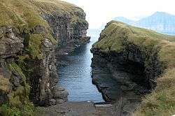
The village was named after a 200-metre (650 ft) long sea-filled gorge that runs north to the sea from the village.
History
The village was first mentioned in 1584, but it seems to have existed long before then. It has long subsisted on fishing and selling dried and salted fish (klippfiskur in Faroese). At one time as many as 13 fishing boats sailed from Gjógv. Its population has seen a sharp decline in the past 60 years or so. In 1950 the headcount still stood at 210. A factory producing prefabricated concrete elements was founded in the village in 1982. It employs 6 people and is the only one of its kind in the islands. Other branches of industry are represented by the village's fish farm and guest house / hostel and campsite.
Sights
The village church dates from 1929. It was the first one to be consecrated in the village and the first one to feature services in Faroese. Before that, the villagers walked to Funningur for church and burial services.[1] On the opposite side of the road a sculpture stands as a memorial to fishermen lost at sea, bearing the names and ages of men from the late nineteenth to the mid twentieth century. The sculpture of a mother and two children looking out to sea was created by Janus Kamban, (http://www.gjogv.fo/Default.asp?sida=344 says: Fritjof Joensen) who has created a number of Faroese commemorative statues.[1]
The village school building dates back to 1884. It was built from boulders and was once in use by as many as 50 pupils. Now there are only three. The old village dance hall was renovated and extended in 1986 and now houses a community centre. All houses in the village conform to the prevailing colourful style of building in the Faroes, red, white and green being the predominant colours used. There are still about 50 houses left in the village. Due to the great decrease in population, about half of that number stand empty.
The nearest grocery store is at Eiði, but Gjógv has a post office in a private home, which opens five days a week for 30 minutes each morning and afternoon. There is also a helicopter pad in the village, used mainly for emergency ambulance service or sea-rescue operations.[1]
Gjógv has one of the best natural harbours in the Faroes. However, boats need to be pulled up on a ramp to be safe from the surf. To tourists and boating natives alike, the harbour in the gorge is also a well-known site of outstanding natural scenery. The village gets its name from the gorge, Faroese gjógv is derived from the same Norse word (gjó) as the Shetlandic geo. The inhabitants are known as Gjáarfólk, possibly related to the Icelandic word gjá which itself comes from the Old Norse gjó from which the village name is derived.[1]
Danish crown prince Frederik and Crown Princess Mary visited Gjógv on 22 June 2005. Two elderly inhabitants named Rita and Christian had the original idea of placing a bench with a magnificent view along the gorge towards the sea. The bench was baptised 'Mary's bench' (boldly proclaimed by a brass plaque attached to it) and the Crown Princess subsequently became the first to be seated on it. They were also serenaded by Faroese opera singer Rúni Brattaberg on this occasion.
Surroundings
A number of tracks head up into the uplands north and west of the village. The highest peaks between Gjógv and the neighbouring village of Eiði are Slættaratindur (882 m, 2,894 ft) and Gráfelli (857 m, 2,812 ft). The valley of Ambadalur is located just northwest of Gjógv. Just off the coast at Ambadalur the highest free-standing sea-stack in the Faroes is to be found. It reaches up to an astounding 188 metres (617 ft). Locally known as Búgvin, it offers a safe perch for multitudes of seabirds. The peaks of Tyril and Middagsfjall (601 m, 1,972 ft) are found east of Gjógv. Both peaks offer a phenomenal view of Funningsfjørður (Funningur's Fjord).
Noted natives and residents
- Joen Danielsen (1843–1926) poet
- Kristin Hervør Lützen, actress
- Hans Jacob Debes (1940–2003), historian.
- Sigurð Joensen (1911-1993), lawyer, author, politician
Gallery
.jpg) Village centre
Village centre.JPG) Gjógv in spring
Gjógv in spring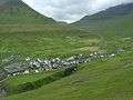 Gjógv in its natural setting
 Gjógv
Gjógv.jpg) Gjógv Church
Gjógv Church Memorial of people who lost their lives at sea
.JPG) Winter scene in Gjógv
Winter scene in Gjógv Gjógv
Gjógv
See also
References
External links
- Faroeislands.dk: Gjógv Images and description of all cities on the Faroe Islands.
- Gjáar municipality website (In Faroese only.)
- Gjógv on Google Maps
- Gjógv guesthouse
- Staðanøvn við Gjógv Excellent geographical website, which regrettably enough is only in Faroese, despite having homepages in English and German. The heading "Myndasavn" leads to an extensive image gallery.
| Wikimedia Commons has media related to Gjógv. |
| Look up Gjógv in Wiktionary, the free dictionary. |