Slættaratindur
| Slættaratindur | |
|---|---|
 | |
| Highest point | |
| Elevation | 880 m (2,890 ft) |
| Prominence | 880 m (2,890 ft) |
| Coordinates | 62°17′47″N 7°00′45″W / 62.29639°N 7.01250°WCoordinates: 62°17′47″N 7°00′45″W / 62.29639°N 7.01250°W |
| Geography | |
 Slættaratindur Location of Slættaratindur in the Faroe Islands | |
| Location | Eysturoy, Faroe Islands |
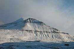
Slættaratindur is the highest mountain in the Faroe Islands, at an elevation of 880 metres.[1] It is located in the northern part of Eysturoy, between the villages of Eiði, Gjógv, and Funningur. Funningur lies at the foot of the mountain.
Its name means "flat summit". It can be climbed in about four hours, and although the routes are steep, technical climbing skills are not necessary to reach the summit. In clear weather the summit gives views over the entire archipelago. Slættaratindur is one of ten mountains in the Faroe Islands which rise to over 800m above sea level. Gráfelli, the second-highest peak at 856 m, lies just to the north-east of Slættaratindur.
According to Guinness World Records Slættaratindur is the object of the world's longest sight line, 550 km from Vatnajökull, the largest glacier in Iceland. GWR state that "owing to the light bending effects of atmospheric refraction, Vatnajökull (2119m), Iceland, can sometimes be seen from the Faroe Islands, 340 miles (550km) away". This may be based on a claimed sighting of Vatnajökull by a British sailor in 1939, during the British occupation of the Faroe Islands in World War II when they were used to monitor German shipping and U-boat movements. The validity of this record is analysed/undermined in mathematical and atmospheric detail by J.C. Ferranti.[2]
References
.jpg)