Juratinden
| Juratinden | |
|---|---|
| Gjuratinden | |
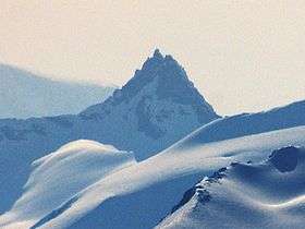 Juratinden seen from Dronningkrona (north east) | |
| Highest point | |
| Elevation | 1,712 m (5,617 ft) |
| Prominence | 285 m (935 ft) |
| Coordinates | 62°34′01″N 08°02′49″E / 62.56694°N 8.04694°ECoordinates: 62°34′01″N 08°02′49″E / 62.56694°N 8.04694°E |
| Geography | |
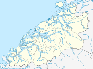 Juratinden Location in Møre og Romsdal | |
| Location | Nesset and Rauma, Møre og Romsdal, Norway |
| Parent range | Romsdalsalpene |
| Topo map | 1320 II Eresfjord |
| Climbing | |
| First ascent | 1880 – Iver Kavli and Bård Moen northeast-ridge |
| Easiest route | Climbing |
Juratinden or Gjuratinden is a mountain on the border of the municipalities of Nesset and Rauma in Møre og Romsdal county, Norway. It is located about 15 kilometres (9.3 mi) east of Isfjorden and about 20 kilometres (12 mi) east of Åndalsnes. The lake Eikesdalsvatnet lies about 5 kilometres (3.1 mi) to the east of the mountain. The mountain Kyrkjetaket lies about 9 kilometres (5.6 mi) to the northwest.[1]
The mountain is 1,712 metres (5,617 ft) tall. The summit climb is close to scrambling, but a rope is recommended for the final 20 to 30 metres (66 to 98 ft).
References
- ↑ "Gjuratinden" (in Norwegian). yr.no. Retrieved 2010-10-26.
This article is issued from Wikipedia - version of the 5/28/2015. The text is available under the Creative Commons Attribution/Share Alike but additional terms may apply for the media files.