Glasshouse Yard
| Glasshouse Yard | |
|---|---|
 Civil parish (3) within the Metropolitan Borough of Finsbury in 1911 | |
| Area | |
| • 1801–1911[1] | 5.6 acres (0.023 km2) |
| • Coordinates | 51°31′17″N 0°05′53″W / 51.5214414°N 0.0979435°WCoordinates: 51°31′17″N 0°05′53″W / 51.5214414°N 0.0979435°W |
| Population | |
| • 1801[1] | 1,221 |
| • 1841[1] | 1,415 |
| • 1881[1] | 931 |
| • 1911[1][2] | 463 |
| History | |
| • Created | Seventeenth century |
| • Abolished | 1915 |
| • Succeeded by | Finsbury |
| Status | Civil parish, liberty, extra-parochial area |
The Liberty of Glasshouse Yard was an extra-parochial liberty adjacent to the City of London. The liberty took its name from a glass manufacturing works established there.[3][4][5] The area now forms part of the London Borough of Islington.
Formation
The area that became the liberty was originally an outlying part of the parish of St Botolph without Aldersgate. Most of the parish lay within the boundaries of the City of London, with a small part lying in the adjoining county of Middlesex.[6] Over time the population of the Middlesex portion of the parish increased as it became a suburb of London, and when the Elizabethan Poor Law was introduced, a separate administration was formed.[3]
The Glasshouse
The liberty became the site of a "glasshouse" or glass-making factory, probably in the reign of Elizabeth I, whose government pursued a policy of encouraging new industries. Such activities were banned from the area of the City itself, and so were set up in the area immediately adjoining it.[7] By 1661 the factory was manufacturing crystal glass. By the end of the century, however, it appears to have been closed.[8]
Extent
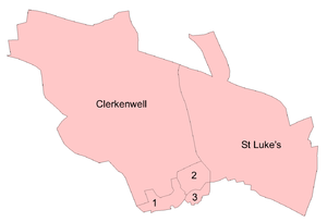
The Liberty of Glasshouse Yard was bounded to the south by the City, to the east by the parish of St Sepulchre to the northeast by the Liberty of Charterhouse and to the north and north west by the parish of St Luke's. It had an area of 5.6 acres (0.023 km2),[1] and by the 19th century was covered by parts of Goswell Street and Pickaxe Street.[3][4][5][9]
Governance
Finsbury division
The liberty formed part of Ossulstone Hundred, one of six administrative divisions of the County of Middlesex.[10] Ossulstone was the hundred nearest the City, and saw great population growth. By the 17th century it was found necessary to divide the ancient hundred into three autonomous divisions, and Glasshouse Yard became part of the Finsbury Division.[11]
Poor law
The liberty was a separate jurisdiction from the remainder of the parish of St Botolph for the administration of the poor law,[3][12] and by the early eighteenth century the chief officer was known as the "headborough".[13] The Poor Law Amendment Act 1834 allowed for the grouping of parishes into Poor Law Unions, with a single workhouse established in each union. In 1837 Glasshouse Yard was included in the East London Poor Law Union, which comprised the City parishes of St Botolph, Aldersgate, St Botolph, Aldgate, St Botolph, Bishopsgate and St Giles, Cripplegate.[11][14][15] A board of guardians of twenty members was formed, with 2 being elected from the parish of St Botolph Aldersgate.[16] The union built a workhouse at Homerton in 1852.[14][16]
The Poor Law Amendment Act 1866 provided that all areas for which a separate poor rate was made were to be constituted as parishes, and accordingly Glasshouse Yard became a distinct civil parish separate from its mother parish.[12][17] In 1869 the East London PLU was merged with two other unions to form the City of London Poor Law Union, covering 118 parishes.[14][15] In 1901 Glasshouse Yard was transferred to the Holborn Poor Law Union.[15][18]
Holborn District Board
The Metropolis Management Act 1855 introduced the first modern local government bodies to govern the built-up area of London. The act introduced two tiers of administration: the Metropolitan Board of Works (MBW) which was to undertake major infrastructure projects with below it a lower level of incorporated parish vestries or district boards. District boards covered two or more parishes and consisted of a number of elected vestrymen from each constituent parish, the number depending on population. The Holborn District Board of Works covered five Middlesex parishes and consisted of forty-nine vestrymen, of which one represented Glasshouse Yard.[19] The first elections were held in November 1855, when the entire membership of the board was elected. Thereafter elections for one third of the seats were held in May, beginning in the year 1857.[20]
In 1889 the area of the Metropolitan Board became the County of London, and the London County Council replaced the MBW. The district board continued to exist for a further eleven years.
Metropolitan Borough of Finsbury
The London Government Act 1899 abolished the vestries and district boards within the County of London, replacing them with twenty-eight metropolitan boroughs. On 1 November 1900 Glasshouse Yard became part of the Metropolitan Borough of Finsbury which also consisted of the parishes of Charterhouse, Clerkenwell, St Luke and St Sepulchre.[21] Glasshouse Yard was formally abolished in 1915 when the five parishes in the borough were merged into a single parish of Finsbury.[22]
Modern development
The area once occupied by the liberty has been extensively redeveloped since the Second World War. A modern street named Glasshouse Yard has been constructed to the west of Goswell Road and adjacent to the Golden Lane Estate.[23]
References
- Youngs, Frederic A, Jr. (1979). Guide to the Local Administrative Units of England, Vol.I: Southern England. London: Royal Historical Society. ISBN 0-901050-67-9.
- 1 2 3 4 5 6 William Page, ed. (1911). "Table of population, 1801-1901". A History of the County of Middlesex. Victoria County History. 2. British History Online. pp. 112–120. Retrieved 5 March 2011.
- ↑ "Glasshouse Yard ExP/CP/ParLib: Census Tables". A Vision of Britain Through Time. University of Portsmouth and Others. Retrieved 5 March 2011.
- 1 2 3 4 Noorthouck, John (1773). "2 The suburbs of the City". A New History of London: Including Westminster and Southwark. 2. British History Online. pp. 747–768. Retrieved 4 March 2011.
- 1 2 Elmes, James (1831). A Topographical Dictionary of London and its environs. British History Online. p. 211. Retrieved 4 March 2011.
- 1 2 Harben, Henry A (1918). A Dictionary of London. British History Online. Retrieved 4 March 2011.
- ↑ "The Metropolis: Its Boundaries, Extent, and Divisions for Local Government". Journal of the Statistical Society of London. 7 (1): 69–85. April 1844. doi:10.2307/2337746.
|first1=missing|last1=in Authors list (help) - ↑ Ditchfield (editor), Peter Hampson (1908). Memorials of Old London. II. Bemrose & Sons. p. 49. Retrieved 4 March 2011.
- ↑ Watts, David (2001). "Glasshouses". Glassmaking in London. Retrieved 4 March 2011.
- ↑ "SAINT BOTOLPH ALDERSGATE: CITY OF LONDON". AIM 25. Retrieved 4 March 2011.
- ↑ Youngs (1979) p.647
- 1 2 Samuel Lewis, ed. (1848). A Topographical Dictionary of England. London: British History Online. pp. 294–298.
- 1 2 Youngs (1979) p.323
- ↑ William John Hardy, ed. (1905). "Sessions Books: 1709". Middlesex county records. Calendar of Sessions Books 1689-1709. pp. 335–353.
- 1 2 3 Higgon, Katharine (2009). "CITY OF LONDON BOARD OF GUARDIANS". Archives in London and the M25 area. AIM25. Retrieved 6 March 2011.
- 1 2 3 Youngs (1979) p.649
- 1 2 Higginbotham, Peter (14 June 2010). "East London". The Workhouse. Retrieved 6 March 2011.
- ↑ "Status details for Civil Parish". A Vision of Britain. University of Portsmouth and others. Retrieved 6 March 2011.
- ↑ Higgon, Katharine (2009). "HOLBORN BOARD OF GUARDIANS". Archives in London and the M25 area. AIM 25. Retrieved 6 March 2011.
- ↑ Metropolis Management Act 1855 Schedule 2
- ↑ Metropolis Management Act 1855, ss.7-9
- ↑ Youngs (1979) p.645
- ↑ Youngs (1979) p.305
- ↑ "Glasshouse Yard". Google Maps. Retrieved 6 March 2011.
| Districts |  | |
|---|---|---|
| Attractions |
| |
| Street markets | ||
| Parks and open spaces |
| |
| Constituencies | ||
| Tube and rail stations | ||
| Other topics | ||
History of the formation of the London Borough of Islington | ||
|---|---|---|
| Metropolitan boroughs |  | |
| District boards | ||
| Parishes | ||