Farringdon, London

Coordinates: 51°31′15″N 0°06′13″W / 51.520905°N 0.103675°W
Farringdon is a historic area of the City of London, represented today by the Wards of Farringdon Within and Farringdon Without. Farringdon is also used informally to refer to the area around Farringdon Station in the London Borough of Islington, some distance north of the historic locality.
Toponymy
There are numerous places in England called Farringdon; all meaning fern covered hill. William and Nicholas de Faringdon, whose name is likely to have originated from one of these places, were two related prominent citizens and Aldermen in the early 13th century.[1] Nicholas purchased the area of the Farringdon ward of the City of London in 1279 and became its Alderman in 1281.[2] In 1394 the ward was split into the still extant Farringdon Within[3] and Farringdon Without.[4]
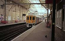
Farringdon Station was built close to Farringdon Road, a northern continuation of Farringdon Street outside the City, after which it was originally named when first opened in 1863 as Farringdon Street Station.[5] Farringdon Street was built over the River Fleet in 1737 and takes its name from either the Farringdon Wards of the City[2] or was named in honour of Nicholas de Faringdon.[1] The road was widened in 1829.[6] The area was previously the location of Farringdon Market, established for the sale of fruit and vegetables on 20 November 1826 when the earlier Fleet Market was cleared to enable the laying out of Farringdon Street [7][8] The station was renamed Farringdon & High Holborn in 1922 and finally Farringdon in 1936.[5]
City of London wards
In the City of London there are two Wards for Farringdon — Farringdon Within and Farringdon Without — a situation caused by the splitting of the original Farringdon Ward in 1394. "Without" and "Within" denote whether the Ward fell outside or within the London Wall — this was also the case for the Wards of Bridge Within and Bridge Without. These Wards cover a fairly considerable part of the City, though before 2004 these Wards covered an even wider area: Farringdon Without stretched from Chancery Lane including Middle Temple, Inner Temple and across to Smithfield[9] while Farringdon Within covered the area within the Walls across to Cheapside at Wood Street and included New Change and Blackfriars Bridge. Blackfriars and St Bartholomew's Hospital.[10][11]
A major review of the City's Wards in 2003, effected in 2004, removed from Farringdon Without the areas north of Fleet Street between Fetter Lane and Farringdon Street and south of Fleet Street between New Bridge Street and Temple Avenue to Castle Baynard Ward. However a 'corridor' connects the western area along Holborn to Smithfield. The area of Farringdon Within at Cheapside was transferred to Bassishaw Ward; the area around Blackfriars Lane and the Blackfriars Bridge was assigned to Castle Baynard.
A map based on Stow c 1600[12] shows the Fagswell Brook south of Cowcross Street as the northern boundary of the City with the bar at Long Lane.
Until 1993, a small triangle of land south of Cowcross Street was within the City of London and formed part of the Farringdon Without ward.[13][14] The boundary between the City of London and the London Borough of Islington was locally realigned in 1993 with exchanges of land between each; in this area the boundary was moved slightly south to align with Charterhouse Street.[15][16]
Informal use
The extent of the area around Farringdon Station which is sometimes referred to as Farringdon cannot be exactly defined; this contemporary usage is most likely a back-formation and its use is similar to that in the Victoria area.
The station and its immediate environs are located at the southernmost tip of Clerkenwell in the London Borough of Islington very close to the northern boundary of the City of London and the eastern boundary of the London Borough of Camden.[17] Farringdon Station and its environs were previously within the Metropolitan Borough of Finsbury[18] and are now within the London Borough of Islington.[19]
Planned redevelopment and expansion of Farringdon Station is expected to have a significant effect on the local area. The station is currently served by the Thameslink north-south rail route; it is planned that this will be supplemented by a future east-west Crossrail service which will require the construction of additional station entrances.[20] Crossrail opened an Information Exchange in Farringdon in 2004 to aid consultation with local stakeholders.[21] A proposed upgrade of the Thameslink route would also affect the local area, including the construction of further station entrances, the pedestrianisation of Cowcross Street and the demolition of several buildings.[22] The area forms part of the City Fringe Partnership, an initiative between the City of London and other local authorities to revive parts of Inner London immediately adjacent to the City.[23] In 2008 a plan to significantly redevelop the area, including the demolition of part of Smithfield Market, was rejected by the Department of Communities and Local Government.[24]
References
- 1 2 Mills, A., Oxford Dictionary of London Place Names, (2000)
- 1 2 Smith, A., Dictionary of City of London street names, (1970)
- ↑ Victorian London - Farringdon Within. Retrieved 26 October 2006.
- ↑ Victorian London - Farringdon Without. Retrieved 26 October 2006.
- 1 2 Rose, Douglas (1999). The London Underground: A diagrammatic history. Capital Transport Publishing. ISBN 1-85414-219-4.
- ↑ Ekwall, E., Street names of the City of London, (1954)
- ↑ SAVE Britain's Heritage (2007). Don't Butcher Smithfield. The threat to Britain's finest group of market buildings. (PDF). ISBN 0-905978-45-5. Retrieved 2007-11-06.
- ↑ Perseus Digital Library - Henry Mayhew, London Labour and the London Poor: Volume 1. Retrieved 28 October 2006.
- ↑ Corporation of London - Farringdon Without. Retrieved 20 October 2006.
- ↑ Corporation of London - Farringdon Within. Retrieved 20 October 2006.
- ↑ The Farringdon Wards of the City of London Tony Sharp 2000
- ↑ Ekwall, E., Street-names of the City of London, (1954)
- ↑ Corporation of London, City of London unitary development plan, (1984)
- ↑ Corporation of London, City of London unitary development plan, (1989)
- ↑ OPSI - The City and London Borough Boundaries Order 1993. Retrieved 20 October 2006.
- ↑ Corporation of London, City of London unitary development plan, (1993)
- ↑ Islington London Borough Council - High detail map with City/Islington boundary shown (PDF). Retrieved 26 October 2006.
- ↑ Vision of Britain - Historic boundaries of the Metropolitan Borough of Finsbury. Retrieved 28 October 2006.
- ↑ Islington London Borough Council, Islington development plan, (1978)
- ↑ Crossrail - Farringdon (PDF). 28 October 2006
- ↑ Crossrail - Crossrail launches Round 2 Consultation with new Farringdon and Spitalfields Information Exchanges. Retrieved 28 October 2006.
- ↑ Network Rail - Statement of Case (PDF). Retrieved 28 October 2006.
- ↑ City Fringe Partnership - About us. Retrieved 28 October 2006.
- ↑ BBC News - Smithfield market plans refused
| Wards |  | |
|---|---|---|
| Enclaves | ||
| Localities | ||
| Attractions |
| |
| Notable structures | ||
| Civil parishes | ||
| Bridges | ||
| Rail and tube stations | ||
| Topics | ||
| ||
| Districts |  | |
|---|---|---|
| Attractions |
| |
| Street markets | ||
| Parks and open spaces |
| |
| Constituencies | ||
| Tube and rail stations | ||
| Other topics | ||