Glen Osmond, South Australia
| Glen Osmond Adelaide, South Australia | |||||||||||||
|---|---|---|---|---|---|---|---|---|---|---|---|---|---|
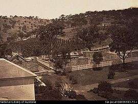
 Glen Osmond around 1869. | |||||||||||||
| Population | 2,035 (2006 Census)[1] | ||||||||||||
| Postcode(s) | 5064 | ||||||||||||
| LGA(s) | City of Burnside | ||||||||||||
| State electorate(s) | Bragg | ||||||||||||
| Federal Division(s) | Sturt | ||||||||||||
| |||||||||||||
Glen Osmond is a suburb of Adelaide, South Australia in the City of Burnside which is in the foothills of the Adelaide Hills. It is well-known for the road intersection on the western side of the suburb, where the South Eastern Freeway (National Route M1) from the Adelaide Hills and the main route from Melbourne splits into National Route A17 Portrush Road (north, the main route towards Port Adelaide), Glen Osmond Road, Adelaide (northwest towards Adelaide city centre) and state route A3 Cross Road west towards the coast and southern suburbs.
History
In 1841, silver and lead were found at Glen Osmond, leading to the establishment of the Wheal Gawler and Wheal Watkins mines.[2] The mines operated in the 1840s, and again in the 1890s.
References
- ↑ Australian Bureau of Statistics (25 October 2007). "Glen Osmond (State Suburb)". 2006 Census QuickStats. Retrieved 7 June 2008.
- ↑ "The Glen Osmond Mines". Flinders Ranges Research. Retrieved 31 October 2016.
| Wikimedia Commons has media related to Glen Osmond, South Australia. |
Coordinates: 34°57′36″S 138°38′28″E / 34.960°S 138.641°E