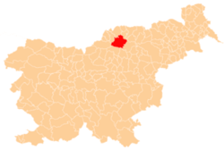
Gmajna, Slovenj Gradec
| Gmajna | |
|---|---|
 Gmajna Location in Slovenia | |
| Coordinates: 46°31′20.18″N 15°3′41.99″E / 46.5222722°N 15.0616639°ECoordinates: 46°31′20.18″N 15°3′41.99″E / 46.5222722°N 15.0616639°E | |
| Country |
|
| Traditional region | Styria |
| Statistical region | Carinthia |
| Municipality | Slovenj Gradec |
| Area | |
| • Total | 6.12 km2 (2.36 sq mi) |
| Elevation | 521.9 m (1,712.3 ft) |
| Population (2002) | |
| • Total | 456 |
| [1] | |
Gmajna (pronounced [ˈɡmaːi̯na]) is a dispersed settlement in the City Municipality of Slovenj Gradec in northern Slovenia. It lies in the hills northwest of the town of Slovenj Gradec. The area was traditionally part of Styria. The entire municipality is now included in the Carinthia Statistical Region.[2]
Unmarked grave
Gmajna is the site of an unmarked grave associated with the Second World War. The Sveteč Woods Grave (Slovene: Grobišče Svetečev gozd) is located next to an elder tree in the woods 250 m south of the house at Bukovska Vas no. 18. It contains the remains of a Croatian soldier.[3]
References
External links
This article is issued from Wikipedia - version of the 11/18/2015. The text is available under the Creative Commons Attribution/Share Alike but additional terms may apply for the media files.
