Gmina Gaworzyce
| Gmina Gaworzyce Gaworzyce Commune | ||
|---|---|---|
| Gmina | ||
| ||
 | ||
| Coordinates (Gaworzyce): 51°37′41″N 15°52′50″E / 51.62806°N 15.88056°ECoordinates: 51°37′41″N 15°52′50″E / 51.62806°N 15.88056°E | ||
| Country |
| |
| Voivodeship | Lower Silesian | |
| County | Polkowice | |
| Seat | Gaworzyce | |
| Area | ||
| • Total | 76.99 km2 (29.73 sq mi) | |
| Population (2006) | ||
| • Total | 3,849 | |
| • Density | 50/km2 (130/sq mi) | |
| Website | http://www.republika.pl/gaworzyce2004/ | |

Gmina Gaworzyce is a rural gmina (administrative district) in Polkowice County, Lower Silesian Voivodeship, in south-western Poland. Its seat is the village of Gaworzyce, which lies approximately 20 kilometres (12 mi) north-west of Polkowice, and 98 kilometres (61 mi) north-west of the regional capital Wrocław.
The gmina covers an area of 76.99 square kilometres (29.7 sq mi), and as of 2006 its total population is 3,849.
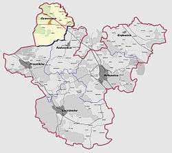
Neighbouring gminas
Gmina Gaworzyce is bordered by the gminas of Niegosławice, Przemków, Radwanice and Żukowice.
Villages
The gmina contains the villages of Dalków, Dzików, Gaworzyce, Gostyń, Grabik, Kłobuczyn, Korytów, Koźlice, Kurów Wielki, Mieszków, Śrem, Wierzchowice and Witanowice.
References
| Seat |  | |
|---|---|---|
| Urban-rural gminas | ||
| Rural gminas | ||
This article is issued from Wikipedia - version of the 2/26/2013. The text is available under the Creative Commons Attribution/Share Alike but additional terms may apply for the media files.