Polkowice County
| Polkowice County Powiat polkowicki | |||
|---|---|---|---|
| County | |||
| |||
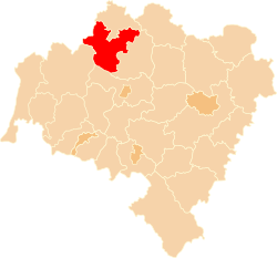 Location within the voivodeship | |||
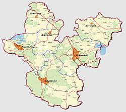 Map of the county | |||
| Country |
| ||
| Voivodeship | Lower Silesian | ||
| Seat | Polkowice | ||
| Gminas | |||
| Area | |||
| • Total | 779.93 km2 (301.13 sq mi) | ||
| Population (2009) | |||
| • Total | 61,622 | ||
| • Density | 79/km2 (200/sq mi) | ||
| • Urban | 37,045 | ||
| • Rural | 24,093 | ||
| Car plates | DPL | ||
| Website | http://www.powiatpolkowicki.pl | ||

Polkowice County (Polish: powiat polkowicki) is a unit of territorial administration and local government (powiat) in Lower Silesian Voivodeship, south-western Poland. It came into being on January 1, 1999, as a result of the Polish local government reforms passed in 1998. The county covers an area of 779.9 square kilometres (301.1 sq mi). Its administrative seat is the town of Polkowice, and it also contains the towns of Chocianów and Przemków.
As at 2006 the total population of the county is 61,138, out of which the population of Polkowice is 22,279, that of Chocianów is 8,215, that of Przemków is 6,551, and the rural population is 24,093.
Neighbouring counties
Polkowice County is bordered by Głogów County to the north, Lubin County to the south-east, Legnica County to the south, Bolesławiec County to the south-west and Żagań County to the west.
Administrative division
The county is subdivided into six gminas (three urban-rural and three rural). These are listed in the following table, in descending order of population.
| Gmina | Type | Area (km²) |
Population (2006) |
Seat |
| Gmina Polkowice | urban-rural | 158.8 | 26,034 | Polkowice |
| Gmina Chocianów | urban-rural | 230.3 | 12,765 | Chocianów |
| Gmina Przemków | urban-rural | 108.0 | 8,826 | Przemków |
| Gmina Grębocice | rural | 121.9 | 5,290 | Grębocice |
| Gmina Radwanice | rural | 84.0 | 4,374 | Radwanice |
| Gmina Gaworzyce | rural | 77.0 | 3,849 | Gaworzyce |
References
| Seat |  | |
|---|---|---|
| Urban-rural gminas | ||
| Rural gminas | ||
| City counties |
|  |
|---|---|---|
| Land counties | ||
Coordinates: 51°50′N 16°05′E / 51.833°N 16.083°E