Gokyo
| Gokyo गोक्यो | |
|---|---|
| Village | |
|
Approaching Gokyo | |
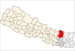
 Gokyo Location in Nepal | |
| Coordinates: 27°57′16″N 86°41′43″E / 27.95444°N 86.69528°ECoordinates: 27°57′16″N 86°41′43″E / 27.95444°N 86.69528°E | |
| Country | Nepal |
| Zone | Sagarmatha Zone |
| District | Solukhumbu District |
| VDC | Khumjung |
| Elevation | 4,750 m (15,580 ft) |
| Time zone | Nepal Time (UTC+5:45) |
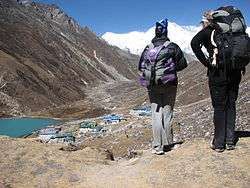
Gokyo is a small village in Solukhumbu District in the Himalayas of Nepal, at the foot of Gokyo Ri and on the eastern shore of Gokyo Cho (Dudh Pokhari). The village, barely a hamlet consisting of several huts, is located at an elevation of 4,750 metres (15,580 ft),[1] making it one of the highest settlements in Nepal and in the world, but likely not permanently inhabited all year around as it is essentially a collection of huts catering to hikers. The village is best viewed on Google Earth at 27°57′16″N 86°41′43″E / 27.95444°N 86.69528°E. To the southeast is the village of Chharchung.
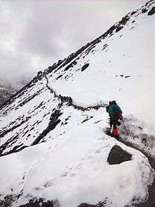

In 1995, an avalanche killed 42 people including 17 foreign nationals (13 Japanese, two Canadians, one Irish woman and a German). A cyclone in the Bay of Bengal had resulted in six feet of snow being dumped into the mountains during the past week, significantly increasing the avalanche hazard.[2]
References
- ↑ Reynolds, Kev (23 April 2012). Everest: A Trekker's Guide: Trekking Routes in Nepal and Tibet. Cicerone Press Limited. p. 151. ISBN 978-1-84965-480-7. Retrieved 13 May 2012.
- ↑ "The Gokyo Avalanche of November 1995". caingram.info. Retrieved 29 April 2014.
External links
Headquarter: Salleri | ||
|  | |