Khumjung
| Khumjung खुम्जुङ | |
|---|---|
| Village development committee | |
|
The mountain Khumbila above the villages Khumjung and Kunde. In the background you can see Mount Everest, Lhotse and Ama Dablam | |
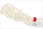
 Khumjung Location in Nepal | |
| Coordinates: 27°49′N 86°43′E / 27.817°N 86.717°ECoordinates: 27°49′N 86°43′E / 27.817°N 86.717°E | |
| Country | Nepal |
| Zone | Sagarmatha Zone |
| District | Solukhumbu District |
| Elevation | 3,790 m (12,430 ft) |
| Population (1991) | |
| • Total | 1,809 |
| Time zone | Nepal Time (UTC+5:45) |
| Area code(s) | 038 |
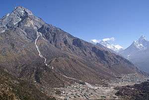
Khumjung (Nepali: खुम्जुंग) is a village and Village Development Committee in Solukhumbu District in the Sagarmatha Zone of north-eastern Nepal. It is located in the Khumbu region inside Sagarmatha National Park, a world heritage site. The village is at an elevation of 3,790 metres above sea level, and is situated near Mount Khumbila.
A monastery in Khumjung has a purported Yeti scalp. This village has modern communications such as the internet and mobile and landline phones.
The village is the seat of Khumjung village development committee which include Kunde, Khumjung, Tengboche (Tyangboche), Pangboche, Pheriche, Dole, Chharchung, Machhermo, Lobuche, Dingboche, and Gokyo. As of 1991, it had a population of 1809 people living in 433 individual households.[1]
Khumjung school was built by Sir Edmund Hillary's Himalayan Trust in 1961.The school began as two classrooms but now caters for pre-school, primary and secondary sections with over 350 students.
Gallery
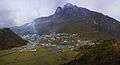 Khumjung village and Mount Khumbila
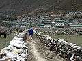 Khumjung village
References
- ↑ "Nepal Census 2001". Nepal's Village Development Committees. Digital Himalaya. Retrieved 2014-10-07.
External links
| Wikimedia Commons has media related to Khumjung. |
Headquarter: Salleri | ||
|  | |