Goldfield, Arizona
Goldfield, later Youngsberg was a gold mining town, now a ghost town northeast of Apache Junction in Pinal County, Arizona.
History
Goldfield
Probably named for the many mines around it, Goldfield was created by the rush that followed the discovery of gold in the vicinity in 1892. The community reached its maximum of about 4000 residents with a general store, hotel, post office, and school.[1] The Goldfield Post Office was established on October 7, 1893 with James L Patterson as its first Postmaster.[2] By late 1897 the gold mines had played out and the population moved out leaving a ghost town.[3] The Goldfield post office was discontinued on November 2, 1898.[2][4]
Youngsberg
After several years a small community evolved on the site of the old ghost town. It was named Youngsberg in honor of George U. Young, the Arizona Territorial Secretary from 1909 to 1910. When mines were opened nearby, a mill and cyanide plant was installed reviving the town. A Youngsberg Post Office was established on March 15, 1920, but when the mines again played out the town was deserted and the post office was discontinued on October 30, 1926.[2][3]
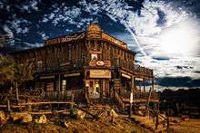
The site today
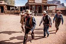


This site is now home to the Goldfield Ghost Town tourist destination.[3] The site features gunfights, train rides on the 3 ft (914 mm) narrow gauge Superstition Narrow Gauge Railroad, several tours, and gold panning.[1]
See also
References
- 1 2 Marshall, John (October 19, 2014). "Ghost Towns". The Post Crescent. Associated Press. p. F2.
- 1 2 3 Granger, Byrd H., Arizona's Names (X Marks the Place). Tucson: The Falconer Publishing Company, 1983. p.692
- 1 2 3 Granger, Byrd H., Arizona's Names (X Marks the Place). Tucson: The Falconer Publishing Company, 1983. p.691
- ↑ "Pinal County". Jim Forte Postal History. Retrieved 16 November 2014.
External links
| Wikimedia Commons has media related to Goldfield Ghost Town. |
- Goldfield or Youngsberg from ghosttowns.com accessed November 15, 2014.
- Goldfield Ghost Town
Municipalities and communities of Pinal County, Arizona, United States | ||
|---|---|---|
| Cities | 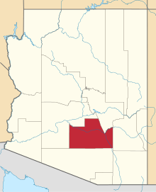 | |
| Towns | ||
| CDPs |
| |
| Unincorporated communities | ||
| Indian reservations | ||
| Ghost towns | ||
| Footnotes | ‡This populated place also has portions in an adjacent county or counties | |
Coordinates: 33°27′28″N 111°29′15″W / 33.45778°N 111.48750°W