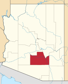
Sacaton (Pima: Geʼe Ki:) is a census-designated place (CDP) in Pinal County, Arizona, United States. The population was 1,584 at the 2000 census. It is the capital of the Gila River Indian Community.
Geography
Sacaton is located at 33°4′48″N 111°44′45″W / 33.08000°N 111.74583°W / 33.08000; -111.74583 (33.079911, -111.745784).[1]
According to the United States Census Bureau, the CDP has a total area of 2.4 square miles (6.2 km2), all of it land.
Demographics
As of the census[2] of 2000, there were 1,584 people, 378 households, and 303 families residing in the CDP. The population density was 667.1 people per square mile (258.1/km²). There were 387 housing units at an average density of 163.0/sq mi (63.0/km²). The racial makeup of the CDP was 1.96% White, 95.01% Native American, 0.06% Asian, 0.63% from other races, and 2.34% from two or more races. 7.07% of the population were Hispanic or Latino of any race.
There were 378 households out of which 40.7% had children under the age of 18 living with them, 26.2% were married couples living together, 41.3% had a female householder with no husband present, and 19.6% were non-families. 15.3% of all households were made up of individuals and 5.8% had someone living alone who was 65 years of age or older. The average household size was 3.80 and the average family size was 4.12.
In the CDP the population was spread out with 38.4% under the age of 18, 11.7% from 18 to 24, 28.4% from 25 to 44, 16.0% from 45 to 64, and 5.6% who were 65 years of age or older. The median age was 25 years. For every 100 females there were 95.1 males. For every 100 females age 18 and over, there were 97.6 males.
The median income for a household in the CDP was $18,276, and the median income for a family was $20,766. Males had a median income of $25,882 versus $23,750 for females. The per capita income for the CDP was $6,425. About 36.4% of families and 39.9% of the population were below the poverty line, including 45.4% of those under age 18 and 31.1% of those age 65 or over.
History
Sacaton is one and a quarter miles west of the 1858-1861 location of the Socatoon Station of the Butterfield Overland Mail. The station was named for the nearby Maricopa village of Sacaton four miles down the Gila from the station.
It was an adobe building established in 1858 on the Little Gila river also known as Capron's Rancho and was also a trading post.[3]
Notable people
Gallery of historic structures and monuments
Historic Sacaton, Arizona
(NRHP = National Register of Historic Places) |
|---|
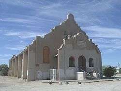
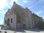
| Side view of the C. H. Cook Memorial Church, a historic church on Church Street. It was built in 1918 and added to the National Register in 1975. The church is named after Charles Cook a young missionary who arrived in Sacaton on December 23, 1870. The funeral of Ira Hayes was held there. The church was listed in the National Register of Historic Places on August 28, 1975, reference # 75000359. |
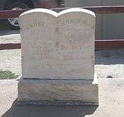
| The grave of Charles Cook’s son, Franklin who died on February 22, 1884 at the tender age of three months and six days. Lying next to her baby is Cook’s wife Annie M. Cook (Coates) who died on December 18, 1889. On the northwest edge of the C. H. Cook Memorial Church. |
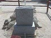
| The grave of Mathew B. Juan whose body was interred in the cemetery on April 9, 1921. Juan’s first name was misspelled, it is Matthew. Juan was killed in WW l, the first Arizona Native American to die in a war. On the northwest edge of the C. H. Cook Memorial Church where there is a small cemetery. |
| The grave of American Civil War Veteran and Confederate Colonel James Patton Perkins who died in Sweetwater, Arizona in 1896. The grave is located on the northwest edge of the C. H. Cook Memorial Church. |
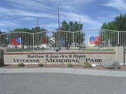
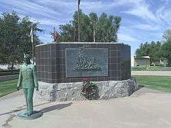
| The Matthew B. Juan-Ira H. Hayes Veterans Memorial Park'. The Memorial Park commemorates Matthew B. Juan a Pima Indian who was the first Arizona Native-American to be killed in World War One. Ira Hayes was a Pima Indian who served in the United States Marine Corps who is best known for his participation in the U.S. flag rising at Iwo Jima in 1945. The park is located on West Casa Blanca Road in Sacaton. |
| The Pvt. Matthew B. Juan Monument built in 1928 by stonemason Michael Sullivan, in the Mathew B. Juan-Ira H. Hayes Veterans Memorial Park. |
| The Ira H. Hayes Monument in the Mathew B. Juan-Ira H. Hayes Veterans Memorial Park. |
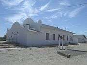
| The First Pima Baptist Church a.k.a. “The first Southern Baptist Church”, was built in 1925 and is located at N Voak AT W Casa Blanca Road. |
| Old 1920 house' in the town of Sacaton located on Casa Blanca Road in the Gila Indian Reservation. |
|
| Gila River War Relocation Center |
|---|
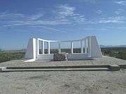
| The Gila River War Relocation Center was an internment camp built by the War Relocation Authority (WRA) for the internment of Japanese Americans during the Second World War. The Gila River War Relocation Memorial is located at Indian Route 24, Sacaton, Az. |
| Different view of the Gila River War Relocation Memorial located in a former internment camp built by the War Relocation Authority (WRA) for the internment of Japanese Americans during the Second World War. |
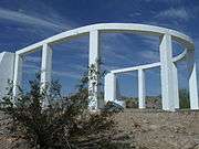
| The Gila River War Relocation Memorial on Butte Mountain. |
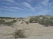
| Ruins of the Gila River Japanese Relocation Internment Camp. |
| Ruins of the Gila River Japanese Relocation Internment Camp. |
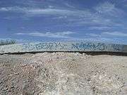
| A concrete slab foundation of the Gila River War Relocation Center. |
|
See also
References
- ↑ "US Gazetteer files: 2010, 2000, and 1990". United States Census Bureau. 2011-02-12. Retrieved 2011-04-23.
- ↑ "American FactFinder". United States Census Bureau. Retrieved 2008-01-31.
- ↑ John P. Wilson, Peoples of the Middle Gila: A Documentary History of the Pimas and Maricopas, 1500's - 1945, Researched and Written for the Gila River Indian Community, Sacaton, Arizona, 1998 (revised July 1999) Report No. 77, Las Cruces, New Mexico, p.137
- ↑ "Mary Thomas Obituary". Azcentral.com. 2014-08-27. Retrieved 2014-10-05.
|
|---|
|
| Core city | |
|---|
|
Largest suburbs
(over 100,000 inhabitants) | |
|---|
|
Other suburbs and towns
(over 10,000 inhabitants) | |
|---|
|
Smaller suburbs and towns
(over 5,000 inhabitants) | |
|---|
|
| Counties | |
|---|
|
| Native American reservations | |
|---|
|
| Subregions | |
|---|


_B._Juan.JPG)


.JPG)