Gonic, New Hampshire
| Gonic, New Hampshire | |
|---|---|
| Unincorporated community | |
|
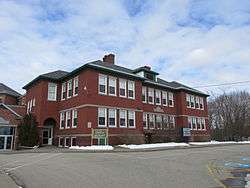
Gonic School | |
 Gonic  Gonic | |
| Coordinates: 43°16′28″N 70°58′41″W / 43.27444°N 70.97806°WCoordinates: 43°16′28″N 70°58′41″W / 43.27444°N 70.97806°W | |
| Country | United States |
| State | New Hampshire |
| County | Strafford |
| City | Rochester |
| Elevation | 190 ft (60 m) |
| Time zone | Eastern (EST) (UTC-5) |
| • Summer (DST) | EDT (UTC-4) |
| ZIP code | 03839 |
| Area code(s) | 603 |
| GNIS feature ID | 867109[1] |
Gonic is a neighborhood in the city of Rochester in Strafford County, New Hampshire, United States. It is located around a dam on the Cocheco River, 2 miles (3 km) south of downtown Rochester. The community is separated from the downtown area of Rochester by New Hampshire Route 16, the Spaulding Turnpike. New Hampshire Route 125 passes to the west of the community, leading south towards East Barrington and the Lee traffic circle.
Gonic has a separate ZIP code (03839) from other parts of Rochester.
References
Municipalities and communities of Strafford County, New Hampshire, United States | ||
|---|---|---|
| Cities |  | |
| Towns | ||
| CDPs | ||
| Other villages | ||
This article is issued from Wikipedia - version of the 6/23/2016. The text is available under the Creative Commons Attribution/Share Alike but additional terms may apply for the media files.