New Hampshire Route 125
| ||||
|---|---|---|---|---|
|
Map of southeastern New Hampshire with NH 125 highlighted in red | ||||
| Route information | ||||
| Maintained by NHDOT | ||||
| Length: | 51.994 mi[1] (83.676 km) | |||
| Major junctions | ||||
| South end: |
| |||
| North end: |
| |||
| Location | ||||
| Counties: | Rockingham, Strafford, Carroll | |||
| Highway system | ||||
| ||||

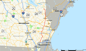
New Hampshire Route 125 is a 51.994-mile-long (83.676 km) north–south state highway in Rockingham and Strafford counties in southeastern New Hampshire. It runs from Plaistow to just north of Milton. Although most of the road consists of only two lanes, NH 125 is a major north–south highway with heavy truck and tourist traffic, especially in the summer months, when the road is used as an alternate route between Interstate 495 in Haverhill, Massachusetts and the Spaulding Turnpike in Rochester.
The southern terminus is in Plaistow at the Massachusetts state line, where the road continues southward as Massachusetts Route 125. The northern terminus of NH 125 is in the village of Union (town of Wakefield) at New Hampshire Route 16 and New Hampshire Route 153.
In the Rochester-Milton area, the road parallels the Spaulding Turnpike and is known as Milton Road in Rochester and White Mountain Highway in Milton. The Epping-Lee-Barrington section is known as the Calef Highway, named after Senator Austin L. Calef who owned the locally famous Calef's Store in Barrington.
The road between Epping and East Barrington (the intersection of NH 125 and NH 9) was built on the grade of the Boston and Maine Railroad's Worcester, Nashua and Portland Division, opened by the Nashua and Rochester Railroad in 1876.
Route description
Going north, Route 125 continues from Haverhill, MA into Plaistow, NH. Route 125 goes directly north, without going east or west much. It has concurrency with Routes 107 and 111. Then it crosses Route 101 at exit 7. After that, it crosses US 4. Then it closely follows Route 16 and parallels the Maine border, until it ends at Routes 153 and 16 in Wakefield.
Major intersections
| County | Location[1][2] | mi[1][2] | km | Destinations | Notes |
|---|---|---|---|---|---|
| Rockingham | Plaistow | 0.000 | 0.000 | Continuation from Massachusetts | |
| 0.035 | 0.056 | Southern terminus of NH 121A | |||
| 2.324 | 3.740 | ||||
| Kingston | 7.406 | 11.919 | Southern end of concurrency with NH 111 | ||
| 9.127 | 14.688 | Southern end of concurrency with NH 107 | |||
| 10.170 | 16.367 | Northern end of concurrency with NH 111 | |||
| 10.701 | 17.222 | Northern end of concurrency with NH 107 | |||
| Brentwood | 12.960 | 20.857 | |||
| Epping | 16.389– 16.524 | 26.376– 26.593 | Exit 7 on NH 101 | ||
| 17.188 | 27.661 | ||||
| 18.899 | 30.415 | Western terminus of NH 87 | |||
| 20.724 | 33.352 | Southern terminus of NH 155 | |||
| Strafford | Lee | 22.001 | 35.407 | ||
| 26.086 | 41.981 | Lee traffic circle | |||
| Barrington | 30.571 | 49.199 | |||
| Rochester | 35.510– 35.747 | 57.148– 57.529 | Exit 12 on Spaulding Turnpike | ||
| 36.971 | 59.499 | Northern terminus of NH 108 Eastern terminus of NH 202A | |||
| 39.142– 39.446 | 62.993– 63.482 | Interchange | |||
| Milton | 43.785 | 70.465 | Eastern terminus of NH 75 | ||
| 50.044– 50.279 | 80.538– 80.916 | Exit 18 on Spaulding Turnpike | |||
| Carroll | Wakefield | 51.708 | 83.216 | Southern end of concurrency with NH 153 | |
| 51.994 | 83.676 | Northern terminus | |||
1.000 mi = 1.609 km; 1.000 km = 0.621 mi
| |||||
References
- 1 2 3 Bureau of Planning & Community Assistance (February 20, 2015). "NH Public Roads". Concord, New Hampshire: New Hampshire Department of Transportation. Retrieved April 7, 2015.
- 1 2 Bureau of Planning & Community Assistance (April 3, 2015). "Nodal Reference 2015, State of New Hampshire". New Hampshire Department of Transportation. Retrieved April 7, 2015.
- Town of Plaistow, Rockingham County
- Town of Kingston, Rockingham County
- Town of Brentwood, Rockingham County
- Town of Epping, Rockingham County
- Town of Lee, Strafford County
- Town of Barrington, Strafford County
- City of Rochester, Strafford County
- Town of Milton, Strafford County
- Town of Wakefield, Carroll County