Gornomariysky District
| Gornomariysky District Горномарийский район (Russian) Курыкмарий кундем (Meadow Mari) Кырык мары кымдем (Hill Mari) | |
|---|---|
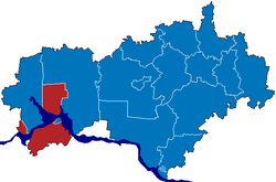 Location of Gornomariysky District in the Mari El Republic | |
 The selo of Paygusovo in Gornomariysky District | |
 |
 |
|
| |
| Location | |
| Country | Russia |
| Federal subject | Mari El Republic[1] |
| Administrative structure (as of October 2014) | |
| Administrative center | town of Kozmodemyansk[2] |
| Administrative divisions:[2] | |
| Rural okrugs | 10 |
| Inhabited localities:[2] | |
| Rural localities | 241 |
| Municipal structure (as of August 2014) | |
| Municipally incorporated as | Gornomariysky Municipal District[3] |
| Municipal divisions:[3] | |
| Urban settlements | 0 |
| Rural settlements | 10 |
| Statistics | |
| Area | 1,730 km2 (670 sq mi) |
| Population (2010 Census) | 25,869 inhabitants[4] |
| • Urban | 0% |
| • Rural | 100% |
| Density | 14.95/km2 (38.7/sq mi)[5] |
| Time zone | MSK (UTC+03:00)[6] |
| Official website | |
| Gornomariysky District on WikiCommons | |
| 2010 Census | 25,869[4] |
|---|---|
| 2002 Census | 29,203[7] |
| 1989 Census | 32,949[8] |
| 1979 Census | 68,476[9] |
Gornomariysky District (Russian: Горномари́йский райо́н; Meadow Mari: Курыкмарий кундем; Hill Mari: Кырык мары кымдем) is an administrative[1] and municipal[3] district (raion), one of the fourteen in the Mari El Republic, Russia. It is located in the west of the republic and is the only district on the right bank of the Volga River. It borders with Yurinsky District in the north, Kilemarsky District and the Chuvash Republic in the south, and with Nizhny Novgorod Oblast in the west. The area of the district is 1,730 square kilometers (670 sq mi). Its administrative center is the town of Kozmodemyansk (which is not administratively a part of the district).[2] As of the 2010 Census, the total population of the district was 25,869.[4]
Administrative and municipal status
Within the framework of administrative divisions, Gornomariysky District is one of the fourteen in the republic.[1] It is divided into 10 rural okrugs, comprising 241 rural localities.[2] The town of Kozmodemyansk serves as its administrative center, despite being incorporated separately as a town of republic significance—an administrative unit with the status equal to that of the districts.[1]
As a municipal division, the district is incorporated as Gornomariysky Municipal District.[3] Its ten rural okrugs are incorporated as ten rural settlements within the municipal district.[3] The town of republic significance of Kozmodemyansk is incorporated separately from the district as Kozmodemyansk Urban Okrug,[3] but serves as the administrative center of the municipal district as well.[10]
Demographics
The district is a home of Hill Mari people, and the Hill Mari language is spoken there.
References
Notes
- 1 2 3 4 Law #22-Z
- 1 2 3 4 5 Resolution #9
- 1 2 3 4 5 6 Law #15-Z
- 1 2 3 Russian Federal State Statistics Service (2011). "Всероссийская перепись населения 2010 года. Том 1" [2010 All-Russian Population Census, vol. 1]. Всероссийская перепись населения 2010 года (2010 All-Russia Population Census) (in Russian). Federal State Statistics Service. Retrieved June 29, 2012.
- ↑ The value of density was calculated automatically by dividing the 2010 Census population by the area specified in the infobox. Please note that this value is only approximate as the area specified in the infobox does not necessarily correspond to the area of the entity proper or is reported for the same year as the population.
- ↑ Правительство Российской Федерации. Федеральный закон №107-ФЗ от 3 июня 2011 г. «Об исчислении времени», в ред. Федерального закона №271-ФЗ от 03 июля 2016 г. «О внесении изменений в Федеральный закон "Об исчислении времени"». Вступил в силу по истечении шестидесяти дней после дня официального опубликования (6 августа 2011 г.). Опубликован: "Российская газета", №120, 6 июня 2011 г. (Government of the Russian Federation. Federal Law #107-FZ of June 31, 2011 On Calculating Time, as amended by the Federal Law #271-FZ of July 03, 2016 On Amending Federal Law "On Calculating Time". Effective as of after sixty days following the day of the official publication.).
- ↑ Russian Federal State Statistics Service (May 21, 2004). "Численность населения России, субъектов Российской Федерации в составе федеральных округов, районов, городских поселений, сельских населённых пунктов – районных центров и сельских населённых пунктов с населением 3 тысячи и более человек" [Population of Russia, Its Federal Districts, Federal Subjects, Districts, Urban Localities, Rural Localities—Administrative Centers, and Rural Localities with Population of Over 3,000] (XLS). Всероссийская перепись населения 2002 года [All-Russia Population Census of 2002] (in Russian). Retrieved August 9, 2014.
- ↑ Demoscope Weekly (1989). "Всесоюзная перепись населения 1989 г. Численность наличного населения союзных и автономных республик, автономных областей и округов, краёв, областей, районов, городских поселений и сёл-райцентров" [All Union Population Census of 1989: Present Population of Union and Autonomous Republics, Autonomous Oblasts and Okrugs, Krais, Oblasts, Districts, Urban Settlements, and Villages Serving as District Administrative Centers]. Всесоюзная перепись населения 1989 года [All-Union Population Census of 1989] (in Russian). Институт демографии Национального исследовательского университета: Высшая школа экономики [Institute of Demography at the National Research University: Higher School of Economics]. Retrieved August 9, 2014.
- ↑ "Всесоюзная перепись населения 1979 г. Национальный состав населения по регионам России. (All Union Population Census of 1979. Ethnic composition of the population by regions of Russia.)". Всесоюзная перепись населения 1979 года (All-Union Population Census of 1979) (in Russian). Demoscope Weekly (website of the Institute of Demographics of the State University—Higher School of Economics. 1979. Retrieved 2008-11-25.
- ↑ Федеральная служба государственной статистики. Федеральное агентство по технологическому регулированию и метрологии. №ОК 033-2013 1 января 2014 г. «Общероссийский классификатор территорий муниципальных образований. Код 88 608». (Federal State Statistics Service. Federal Agency on Technological Regulation and Metrology. #OK 033-2013 January 1, 2014 Russian Classification of Territories of Municipal Formations. Code 88 608. ).
Sources
- Государственное Собрание Республики Марий Эл. Закон №22-З от 3 мая 2006 г. «О порядке решения вопросов административно-территориального устройства (деления) Республики Марий Эл», в ред. Закона №50-З от 31 октября 2014 г. «О внесении изменений в некоторые законодательные акты Республики Марий Эл». Вступил в силу со дня официального опубликования. Опубликован: "Марийская правда", №81, 6 мая 2006 г. (State Assembly of the Mari El Republic. Law #22-Z of May 3, 2006 On the Procedures of the Administrative-Territorial Structure (Division) of the Mari El Republic, as amended by the Law #50-Z of October 31, 2014 On Amending Various Legislative Acts of the Mari El Republic. Effective as of the official publication date.).
- Правительство Республики Марий Эл. Постановление №9 от 18 января 2008 г. «О реестре административно-территориального устройства Республики Марий Эл», в ред. Постановления №555 от 24 октября 2014 г. «О внесении изменения в Постановление Правительства Республики Марий Эл от 18 января 2008 г. №9». Опубликован: "Собрание законодательства Республики Марий Эл", №2, ст. 108, 26 февраля 2008 г. (Government of the Mari El Republic. Resolution #9 of January 18, 2008 On the Registry of the Administrative-Territorial Structure of the Mari El Republic, as amended by the Resolution #555 of October 24, 2014 On Amending Resolution #9 by the Government of the Mari El Republic of January 18, 2008. ).
- Государственный Совет Республики Марий Эл. Закон №15-З от 18 июня 2004 г. «О статусе, границах и составе муниципальных районов, городских округов в Республике Марий Эл», в ред. Закона №50-З от 31 октября 2014 г. «О внесении изменений в некоторые законодательные акты Республики Марий Эл». Вступил в силу через 10 дней после официального опубликования. Опубликован: "Марийская правда", №116, 24 июня 2004 г. (State Council of the Mari El Republic. Law #15-Z of June 18, 2004 On the Status, Borders, and Composition of the Municipal Districts, Urban Okrugs in the Mari El Republic, as amended by the Law #50-Z of October 31, 2014 On Amending Various Legislative Acts of the Mari El Republic. Effective as of after 10 days after the official publication.).
External links
- Official website of Gornomariysky District (Russian)
- Pictures of Gornomariysky District (Russian)
| Districts | |||
|---|---|---|---|
| Cities and towns | |||
| Urban-type settlements | |||