Gothers
| Gothers | |
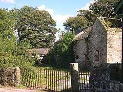 Disused farm buildings at Gothers |
|
 Gothers |
|
| OS grid reference | SW963587 |
|---|---|
| Unitary authority | Cornwall |
| Ceremonial county | Cornwall |
| Region | South West |
| Country | England |
| Sovereign state | United Kingdom |
| EU Parliament | South West England |
Coordinates: 50°23′35″N 4°52′01″W / 50.393°N 4.867°W
Gothers is a hamlet near and northeast of St Dennis in mid Cornwall, England.[1]
The manor of Gothers was recorded in the Domesday Book (1086) when it was held by Sheerwold from Robert, Count of Mortain. He had also held it before 1066. There were 2 acres of land and land for 1 plough. There were 1 villein, 1 serf, a quarter of a square league of pasture, 2 cattle and 9 sheep. The value of the manor was 3 shillings though it had formerly been worth 10 shillings.[2]
References
Cornwall Portal | |
| Unitary authorities | |
| Major settlements |
|
| Rivers | |
| Topics | |
This article is issued from Wikipedia - version of the 3/14/2016. The text is available under the Creative Commons Attribution/Share Alike but additional terms may apply for the media files.