Great and Little Kimble
| Great and Little Kimble | |
 Great Kimble Church |
|
 Great and Little Kimble |
|
| Population | 960 [1] 1,026 (2011 Census)[2] |
|---|---|
| OS grid reference | SP824065 |
| Civil parish | Great and Little Kemble cum Marsh |
| District | Wycombe |
| Shire county | Buckinghamshire |
| Region | South East |
| Country | England |
| Sovereign state | United Kingdom |
| Post town | AYLESBURY |
| Postcode district | HP17 |
| Dialling code | 01296 |
| Police | Thames Valley |
| Fire | Buckinghamshire |
| Ambulance | South Central |
| EU Parliament | South East England |
| UK Parliament | Aylesbury |
|
|
Coordinates: 51°44′47″N 0°48′18″W / 51.7464°N 0.8051°W
Great and Little Kimble is a civil parish in Wycombe district, Buckinghamshire. It is located 5 mi (8.0 km) to the south of Aylesbury. In addition to the villages of Great Kimble and Little Kimble it contains the hamlets of Kimblewick and Marsh, and an area within Great Kimble is called Smokey Row. From the time of the 2011 Census the civil parish is called Great and Little Kimble cum Marsh.
It comprises the ancient ecclesiastical parishes of Great Kimble and Little Kimble and also the medieval Manors which had the same names. The two separate parishes were amalgamated in 1885, but kept their separate churches, St Nicholas for Great Kimble and All Saints for Little Kimble. They fell within the Hundred of Stone, which was originally one of the Three Hundreds of Aylesbury, later amalgamated into Aylesbury Hundred. The parishes lie between Monks Risborough and Ellesborough and, like other parishes on the north side of the Chilterns, were strip parishes, long and narrow, including a section of the scarp and extending into the vale below. In length the combined parish extends for about 4 1⁄4 miles (6.8 km) from near the Bishopstone Road beyond Marsh to the far end of Pulpit Wood near the road from Great Missenden to Chequers but it is only a mile wide at the widest point. The village of Great Kimble lies about 5.5 miles (8.9 kilometres) south of Aylesbury and about 2.5 miles (4.0 kilometres) from Princes Risborough on the A4010 road.
There is a prehistoric hillfort at the summit of Pulpit Hill in Great Kimble. During the Roman occupation of Britain there was a Roman villa at Little Kimble and a tumulus near Great Kimble church is probably a burial mound from the same period. In Norman times a motte and bailey castle was erected at Little Kimble and later developed into a moated site for a medieval dwellinghouse. The present churches of St Nicholas (Great Kimble) and All Saints (Little Kimble) date from the 13th century. It was here that John Hampden refused to pay his ship-money in 1635, one of the incidents which led to the English Civil War.
The origin and meaning of the name Kimble
The name is first found in Anglo-Saxon times when it appeared as cyne belle, which corresponds to two Anglo-Saxon words, cyne meaning 'royal' and belle which is the modern word 'bell'.[3]
(The apparent similarity to the name Cymbeline led (probably in Victorian times) to a theory that the name was derived from his name. This has no basis in fact. Cymbeline (as Shakespeare called him), whose exact name is unknown but which was spelt by the Romans as Cunobelinus, was the leader of the tribe known as the Cassivellauni from about 4 BC to about 41 AD. His tribe occupied part of southern Britain at that time, which was about 800 years before the name first appeared, with 400 years of Roman occupation and several invasions from Europe in the intervening period).[4]
The exact reason for calling the place cyne belle is not certain. Mawer and Stenton, who published their book on the Place Names of Buckinghamshire in 1925, thought that belle could have meant a hill as well as a bell and suggested that the conspicuous hill at Kimble would have impressed itself on the minds of the first settlers and might have been called 'royal' as the largest visible hill in the locality or that it earned the epithet by reason of some royal burial or other unknown event.[5]
The Concise Oxford Dictionary of English Place Names, first published in 1951, interpreted the name as "Royal bell-shaped hill" and the later Oxford Companion to Names (2002) also gives that as the meaning.[6]
The Cambridge Dictionary of English Place Names (2004) gives the translation "Royal Bell, the bell-shaped hill" and says that it is derived from the Old English cyne + belle, probably used as a place-name, and that the reference is to the prominent Pulpit Hill crowned with its hillfort, suggesting that 'royal' referred to Great Kimble for distinction from Little Kimble.[7]
Not all these explanations are completely convincing and there may be more to be said.[8] The precise nature of the Royal Bell in the minds of the inhabitants of Kimble in the 9th century or earlier remains something of a mystery. It must be remembered that Pulpit Hill (or part of it) might then have been unwooded open grassland,[9] which would have made the shape of the hill more apparent from below and the hillfort on the summit (already a thousand years old) would in that case have been clearly visible and impressive and might well have been thought to be a royal castle.
Prehistoric Hillfort on Pulpit Hill
This hillfort is in Pulpit Wood on the summit of Pulpit Hill in Great Kimble, about 3/4 of a mile south-east of the church.[10] It is 813 feet (248 m) above ordnance datum. It has never been excavated and its precise date is unknown, though almost certainly built during the 1st millennium B.C. Hillforts are usually attributed to the Iron Age, but there are a series of hillforts at intervals along the Chiltern ridge and that at Ivinghoe Beacon, which is not far away, has been excavated and found to have been built in the late Bronze Age.[11]
The Pulpit Hill fort follows the contours at the top of the hill and has an area of 0.9 hectares (2.2 acres). The boundary is roughly D-shaped (nearly square) with maximum internal dimensions of 104 by 98 metres (341 ft × 322 ft). There are still double ramparts and ditches on the NE and SE sides, but on the NW and SW sides, which face very steep slopes down the hill, the outer rampart is hardly apparent and there is no sign of an outer ditch. The builders seem to have relied on the steep natural slopes on these sides, though the original ditches may have been eroded away. The entrance is on the SE side, where the ground is level. The ramparts remain imposing after (probably) about 2,500 years. Although now mere banks of earth, they would originally been revetted with timber and boxed in, so that the faces would have been vertical.[12]
The fort, though in a commanding location, was probably not primarily intended as a fortress in time of war. It is likely to have been a centre for storing agricultural produce and used to store grain and to enclose animals from farms in the district (perhaps as protection from cattle raids), as well as being a defensible site if and when the need arose. There is also evidence that hillforts were used for ritual activities, possibly for religious purposes connected with agriculture.[13]
Roman Villa and burial mound
At Little Kimble on the east side of the church are indications of the site of a Roman villa. Foundations, wall plaster, tesselated floors, tiles, coins and pottery have been found there over the past two hundred years, but it has never been properly excavated in modern times.[14]
It would have been the dwelling of a substantial land owner farming a fair-sized estate, probably surrounded by the principal farm buildings. Villas are more common on the south side of the Chilterns, but there are 7 or 8 along the north side below the scarp of which this is one. (There was another at Saunderton). Surplus produce would have been sold at Verulamium (St Albans).[15]
A barrow or funeral mound lies on the west side of Great Kimble church, adjoining the churchyard and fronting on Church Lane. It is known as Dial Hill (from the sundial formerly erected above it) and is believed to date from the Roman period, but has not been properly excavated, although there were limited amateur investigations in 1887 and 1950. It is scheduled as an ancient monument by English Heritage and their description suggests that it might have held the body of the occupant of the Roman villa.[16]
Medieval and later times
Norman Conquest and Domesday Book
Before the Norman conquest of England in 1066 both Great Kimble and Little Kimble were owned by royal Thegns, Sired at Great Kimble and Brictric at Little Kimble. Both were dispossessed by the new king, William of Normandy.
Great Kimble (Chenebelle in Domesday Book) was given to Walter Giffard, Lord of Longueville in Normandy and a cousin of William the Conqueror, who received a total of 107 lordships of land in England, 48 of them in Buckinghamshire.[17] He passed Great Kimble to one of his own followers, sub-granting it to Hugh of Bolbec (a town in Normandy near the mouth of the Seine). Little Kimble (Chenebelle parva) went to Thurston son of Rolf, who sub-granted it to one Albert.
Great Kimble was assessed for taxation at 20 hides, while Little Kimble answered for only 10 hides. The information given in Domesday Book is summarised below. (Numbers of people refer only to the heads of families).[18]
| Great Kimble | Little Kimble | |
|---|---|---|
| Tax assessment | 20 hides | 10 hides |
| Land for | 11 1/2 ploughs | 10 ploughs |
| Ploughs on demesne land | 2 (+1 possible) | 2 (+2 possible) |
| Villagers | 22 | 10 |
| Smallholders | 8 | 1 |
| Ploughs of Villagers & Smallholders | 8 1/2 ploughs | 3 ploughs +3 possible |
| Slaves | 6 | 2 |
| Meadow (for plough teams of 8 oxen) | 11 ploughs | 10 ploughs |
| Other assets | Wood for fences | 1 mill at 16s. |
| Value in 1066 & 1087 | £10 always | £5 (£6 before 1066) |
Motte and Bailey Castle
Behind the church at Little Kimble to the east are mounds and banks in the grass which are all that remain of a motte and bailey castle, which would have been built at the order of the Normans soon after the conquest. These timber castles were built all over England and consisted of a high mound (the Motte), surmounted by a wooden tower, with subsidiary buildings surrounded by a rampart with palisades (the Bailey). At Little Kimble there was a motte, which is still 15 feet high, and two separate baileys, but the layout is not easy to recognise on the ground.[19]
Unlike large stone castles, which were built later at strategic points, these wooden forts were built for the local purposes of the manor rather than for military reasons. The Norman landholder, who was surrounded by hostile Englishmen, wanted a safe residence for himself.[20]
Later Manorial history
The later manorial history of Great Kimble is complicated because various sub-manors were created (known as Whitinghams Manor (or Fenels Grove), Uptons Manor and Marshals) and they each descended in different lines. By the 17th century they had come together again and the manor of Great Kimble was held by the Hampdens of Great Hampden and later sold, in 1730, to Sarah Dowager Duchess of Marlborough. Her successors sold it in 1803 to Scrope Bernard (later Sir Scrope Bernard-Morland, a Baronet), who had been lord of the manor of Little Kimble since 1792, He held both manors until his death in 1830 and they were then sold to Robert Greenhill Russell (created a Baronet in 1831). He lived at Chequers Court and already owned the neighbouring manor of Ellesborough in succession to Sir George Russell. The memory of Scrope Bernard and Sir George Russell was preserved in the names of two public houses, the Bernard Arms at Great Kimble and the Russell Arms at Butlers Cross in Ellesborough.[21]
Churches
_from_west.jpg)
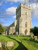
St Nicholas Church, Great Kimble
This church in the 12th century probably consisted only of a nave without aisles and a small chancel. In the middle of the 13th century the north and south aisles were added with the nave arcades and the nave may have been lengthened by one bay. In the first half of the 14th century the chancel arch was added and the chancel rebuilt. The west tower and clerestorey were added later in that century. The nave was re-roofed in the 16th century.
The font (late 12th century) is a finely carved example of the local "Aylesbury" type.
The church was completely restored by J.P. Seddon in 1876–81. All the flint and stone exterior is of that date and the chancel and its aisles were rebuilt. A modern roof was built over the 16th century nave roof.[22]
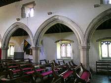
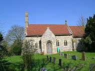
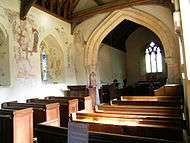
All Saints Church, Little Kimble
A church with chancel and nave existed before the mid-13th century, when the chancel was widened and the chancel arch inserted. The larger window and lowside window in the north wall of the chancel are early 14th century. The north and south porches and the doors and windows of the nave date from the early to mid 14th century.
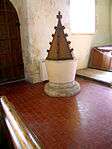
There is a simple font of the late12th or early 13th century and in the chancel are 13th century medieval tiles of Chertsey Abbey type (possibly obtained from the ruins of Chertsey Abbey).
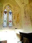
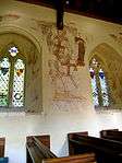
The interior is decorated with the remains of early 14th century wall paintings, most of which appear to have represented saints (the church is dedicated to All Saints). They include St Francis preaching to the birds and a large figure of St George, but not all can be identified. There seems to have been a doom on the west wall, where a devil is pushing two women into the mouth of Hell.[23]
| All Saints Church, Little Kimble | ||||||||||
|---|---|---|---|---|---|---|---|---|---|---|
|
Free Church
There is a small chapel in the Tudor style, built in 1922, to the west of the railway bridge at Little Kimble.[24]
John Hampden and Ship-money
Great Kimble has a special claim to fame as the parish where John Hampden refused to pay his ship-money in January 1635/6.[25] King Charles I, attempting to govern the country without a parliament, needed money to improve the navy and tried to raise it by levying "ship-money" from all the counties of England. Although the writ requiring the payments was worded as imposing an obligation on each county to provide a ship, in fact the money raised went straight to the treasurer of the Navy and was seen as being a tax.[26] It was a long established principle of the constitution that no tax could be raised by the king without the consent of parliament.
Each county had to raise a stated sum which was then divided between all the parishes in the County. Each parish appointed two Assessors to divide this liability between the individual landowners. John Hampden, who owned land in several parishes in Buckinghamshire, was assessed to £8.4s in his own parish of Great Hampden and he paid this and other assessments in full, showing that he was not objecting to the amount nor rejecting an obligation to defend his country. But in two parishes, where he owned less land, he refused payment on the point of principle and others followed his example. The two parishes where he refused payment were Great Kimble, where he was assessed to pay £1.11s.6d, and Stoke Mandeville, where his liability was £1.[27]
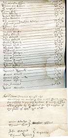
The Assessors for Great Kimble were required to prepare a list of persons failing to pay and this was issued at Great Kimble on 25 January 1635/6. At the head of the list is 'John Hampden 31s.6d.' followed by thirty other names assessed for smaller amounts including the two Assessors themselves and the two parish constables responsible to collect the money.[29]
People throughout the country were refusing payment and the king decided to select one man to be sued in a test case before all the judges in the Court of Exchequer Chamber. He selected John Hampden as the defendant in respect of the round sum of one pound assessed upon him at Stoke Mandeville. (The case did not mention the Great Kimble assessment).[30] Judgment was given for the King but only by a majority decision of seven judges to five, which was seen throughout the country as a moral defeat for the King and was followed by more refusals to pay.
Although the case referred only to Stoke Mandeville, Thomas Carlyle made Great Kimble famous with his description of what had happened, "there, in the cold weather, at the foot of the Chiltern Hills."[31]
Education
Griffin House School, formerly Ladymede School, an independent co-educational school, is located in Little Kimble.[32] It has a capacity of just over 100 day students from ages 3–11.
Notable pupils of Ladymede School
Transport
The main A4010 road runs through Great and Little Kimble, as does the Chiltern railway line between Aylesbury and Princes Risborough. Where the main road meets the railway is Little Kimble railway station, which has been in operation since 1872, although the station buildings are now a private dwelling. There is a level crossing at Marsh.
References
Books referred to in the notes
- Archaeology of the Chilterns from the Ice Age to the Norman Conquest. The; edited by Keith Branigan (Chess Valley Architectural & Historical Society. 1994)
- Armitage, Ella S.: The Norman Castles of the British Isles (London. 1912)
- Barker, Louise: Pulpit Hill, Great and Little Kimble, Buckinghamshire (English Heritage Archaeological Investigation Report series AI/16/2001) (English Heritage. 2001)
- Cambridge Dictionary of English Place-Names based on the collections of the English Place-Name Society, ed: Victor Watts (Cambridge University Press. 2004)
- Carlyle, Thomas: The Letters and Speeches of Oliver Cromwell (London. 1904 edition, edited by S.C.Lomas) (originally published 1845)
- Concise Oxford Dictionary of English Place-Names, ed: Eilert Ekwal (Oxford University Press. 1951)
- Domesday Book vol 13 Buckinghamshire. Text & translation edited by John Morris (Phillimore, Chichester. 1978)
- Forde-Johnstone, James: Hillforts of the Iron Age in England & Wales. A survey of the surface evidence (Liverpool U.P. 1976)
- Lipscomb, George: The History and Antiquities of the County of Buckingham (2 volumes. London. 1847)
- Mawer, A. and Stenton, F.M: The Place Names of Buckinghamshire (Cambridge, 1925)
- Nugent, Lord: Some Memorials of John Hampden, his party and his times. 2 volumes (London. 1832)
- Oxford Companion to Names, ed:, Patrick Hanks, Flavia Hodges, A. D. Mills and Adrian Room (Oxford University Press. 2002)
- Pevsner, Nikolaus & Elizabeth Williamson: Buckinghamshire (The Buildings of England – Penguin Books. 2nd edition. 1994)
- RCHMB = Royal Commission on Historical Monuments (England): An Inventory of the Historical Monuments in Buckinghamshire, Volume 1 (1912)
- Russell, Conrad: Hampden, John (1595–1643) in Oxford Dictionary of National Biography, Volume 24, pp. 975–984 (and in Online edition. 2008)
- VHCB = Victoria History of the County of Buckingham, Volume 2, ed: William Page F.S.A. (1908)
Notes
- ↑ "Neighbourhood Statisitcs 2001 Census". Retrieved 11 September 2010.
- ↑ "Civil Parish population 2011". Neighbourhood Statistics. Office for National Statistics. Retrieved 21 November 2016.
- ↑ Mawer & Stenton p. 13
- ↑ Lipscomb Vol.2 p. 341 mentioned it as a conjecture in 1847
- ↑ Mawer & Stenton p. 13
- ↑ Concise Oxford Dictionary of English Place-names under 'Kimble'. Oxford Dictionary of Names – Place Name Section – p. 1093
- ↑ Cambridge Dictionary of English Place-Names under Kimble, Bucks
- ↑ Mawer & Stenton (p. 13) thought certainty was not possible.
- ↑ Barker p. 17
- ↑ Louise Barker's report for English Heritage (2001) contains a full description and survey of the site, with plans and photographs.
- ↑ Stewart Bryant: 'From Chiefdom to Kingdom' in Archaeology of the Chilterns, p. 52
- ↑ On hillforts generally, see Forde-Johnstone
- ↑ Stewart Bryant: 'From Chiefdom to Kingdom' in Archaeology of the Chilterns, pp. 52–53
- ↑ RCHM Volume 1 p. 164,(3)
- ↑ Keith Branigan: 'The Impact of Rome' in Archaeology of the Chilterns pp. 102–09
- ↑ see www.english-heritage.org.uk List entry number 1017512
- ↑ See The Complete Peerage, ed. the Hon Vicary Gibbs, Volume II (1912) pp. 386–87
- ↑ Domesday Book Vol.13: Land of Walter Giffard 14.2 & Land of Thurston son of Rolf 35
- ↑ Pevsner & Williamson p. 439. The 1/2500 Ordnance Survey map shows the layout.
- ↑ Armitage p. 85
- ↑ For the manorial history of Great Kimble see VHCB pp. 298–302. For Little Kimble see VHCB pp. 303–04
- ↑ RCHM vol.1 p. 164. Pevsner & Williamson p. 350
- ↑ RCHM vol.1 pp. 166–67. Pevsner & Wiiliamson p. 439
- ↑ Pevsner & Williamson p. 439
- ↑ The date is often stated as January 1635. This is the Old Style (as would have been used at the time), when the year did not change until 25 March. Under the present New Style (when the year changes on 1 January) it would have been 1636.
- ↑ Russell pp. 979–80
- ↑ Russell pp. 979–80
- ↑ The facsimile is reproduced from Lord Nugent's book facing page 228 where it is stated to be derived from the original return which was among the papers of Sir Peter Temple at Stowe.
- ↑ Nugent p. 229
- ↑ The case is reported in full with the arguments of Counsel and the opinions of the judges in State Trials Volume 3, p. 825ff
- ↑ Carlyle Vol.1, pp. 82–83
- ↑ See http://www.griffinhouseschool.co.uk/
- ↑ Howard-Gordon, Frances (22 December 2007). "Obituary: Arabella Churchill". The Guardian. Retrieved 11 September 2010.
External links
| Wikimedia Commons has media related to Great and Little Kimble. |
| Towns (component areas and hamlets) |  | |
|---|---|---|
| Other civil parishes (component villages and hamlets) |
| |
| Former districts and boroughs | ||
| Former constituencies | ||