Greiz (district)
| Greiz | |
|---|---|
| District | |
 | |
| Country |
|
| State | Thuringia |
| Capital | Greiz |
| Area | |
| • Total | 844 km2 (326 sq mi) |
| Population (31 December 2015)[1] | |
| • Total | 101,114 |
| • Density | 120/km2 (310/sq mi) |
| Time zone | CET (UTC+1) |
| • Summer (DST) | CEST (UTC+2) |
| Vehicle registration | GRZ, ZR |
| Website | www.landkreis-greiz.de |
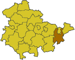
Greiz is a Kreis (district) in the east of Thuringia, Germany. Neighboring districts are (from the west clockwise) Saale-Holzland, Saale-Orla, district-free city Gera, the Burgenlandkreis in Saxony-Anhalt, Altenburger Land, and the two Saxon districts Zwickauer Land and Vogtlandkreis.
History
Historically the area of the district was part of the Vogtland, named after the title Vogt given to the local rulers in the 13th century. Only two lines of the Reuß family survived from that time, with one principality based in Greiz, and the other in Gera and Schleiz. In 1919 both were merged into the Volksstaat Reuß, which then became part of Thuringia in 1920.
A subcamp of the Buchenwald concentration camp was located at Berga/Elster during World War II. It was an SS joint venture, in which inmates dug tunnels and laid railway tracks for the Schwalbe V project.[2]
The district in its current form was created on July 1, 1994, when the districts Gera-Land, Zeulenroda and the previous district Greiz were merged.
Geography
In the south of the district are the mountains of the Thuringian Slate Mountains (Thüringer Schiefergebirge) and the Ore Mountains, with the river valley of the Weiße Elster going through the district from south to north.
Coat of arms
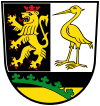 |
Both the lion as well as the crane in the top part of the coat of arms derive from the coat of arms of the Reuß families and their principalities. In the bottom is a part of the coat of arms of Saxony, as a small part of the district belonged to the Duchies of Saxony. |
Towns and municipalities
| Verwaltungsgemeinschaft-free towns | and municipalities | |
|---|---|---|
| Verwaltungsgemeinschaften | ||
|---|---|---|
|
1. Am Brahmetal |
||
| 1seat of the Verwaltungsgemeinschaft;2town | ||
Sights
Sights in the district Greiz:
- The Upper Castle of Greiz
- The Lower Castle of Greiz
- The Summer Palace Greiz
- Weida Osterburg Castle
- Ronneburg Castle
- Reichenfels Castle Ruin
- Old Guardhouse "Alte Wache" in Greiz
- Zeulenroda Town Hall
- Widen Church Ruin in Weida
- St. Veit Parish Church
- Mildenfurth Monastery
- Cronschwitz Monastery Ruin
- Greiz Park
- Fairy Tale Forest in Wünschendorf
Museums in the district Greiz:
- Museum of Local History in Greiz
- Summer Palace in Greiz
- Zeulenroda City Museum in Zeulenroda
- Osterburg Castle Museum in Weida, Thuringia
- Heinrich-Schütz-House in Bad Köstritz
- Museum in Hohenleuben
References
- ↑ "Bevölkerung der Gemeinden, Gemeinschaftsfreie Gemeinde, erfüllende/beauftragende Gemeinden, Verwaltungsgemeinschaft/Mitgliedsgemeinden in Thüringen". Thüringer Landesamt für Statistik (in German). July 2016.
- ↑ Edward Victor. Alphabetical List of Camps, Subcamps and Other Camps. www.edwardvictor.com/Holocaust/List %20 of %20 camps.htm
| Wikimedia Commons has media related to Landkreis Greiz. |
External links
| Urban districts | |
|---|---|
| Rural districts | |
Coordinates: 50°45′N 12°05′E / 50.75°N 12.08°E