Grytten Church
| Grytten Church | |
|---|---|
| Grytten kyrkje | |
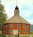
 View of the church | |
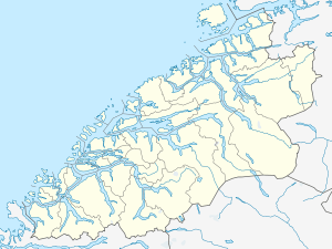 Grytten Church Location in Møre og Romsdal  Grytten Church Location in Møre og Romsdal | |
| 62°33′10″N 7°40′24″E / 62.5528°N 7.6732°ECoordinates: 62°33′10″N 7°40′24″E / 62.5528°N 7.6732°E | |
| Location |
Rauma Municipality, Møre og Romsdal |
| Country | Norway |
| Denomination | Church of Norway |
| Churchmanship | Evangelical Lutheran |
| Architecture | |
| Status | Parish church |
| Functional status | Active |
| Style | Octagonal |
| Completed | 1829 |
| Specifications | |
| Capacity | 250 |
| Materials | Wood |
| Administration | |
| Parish | Grytten |
| Deanery | Indre Romsdal prosti |
| Diocese | Diocese of Møre |
Grytten Church (Norwegian: Grytten kyrkje) is a parish church in Rauma Municipality in Møre og Romsdal county, Norway. It is located near the mouth of the Rauma River in the village of Veblungsnes. The church is part of the Grytten parish in the Indre Romsdal deanery in the Diocese of Møre. The red, wooden, octagonal church was built in 1829 possibly using Sør-Fron Church as a model. The church seats about 250 people. Four large columns support the tower. In the church there is a tall (about 2 meters) wooden crucifix, possibly from the 13th century. The church has so called pulpit altar (Kanzelaltar in German), that is the pulpit is centrally located directly above the altar (according to the style of Sør-Fron Church).[1] The two churchbells are from the previous churches.
This is at least the fourth church in this parish. There was an old stave church, and then a cruciform church before the present church was built.[2][3] The two previous churches were standing at Grytten (or "Grytina") farm (that gave name to church, the parish and to the municipality) between Istra and Rauma rivers, some kilometers south of the present location. Previous name was «Gryttinar kirkja» mentioned in Aslak Bolt's cadastre. The medieval stave church was replaced in 1651, this building fell apart after less than 80 years. The cruciform church (erected about 1730) was threatened by shifting sands along the river banks. Shifting sands was a major problems in the area and large parts of the vicarage (which according to tradition included substantial farmland) was turned into a sand desert. East of the church there was in 1824 a sand dune "9 cubits tall" (about 3 meters) and the church yard was largely covered in sand. The building itself suffered damages from sand penetrating cracks in the walls. The church building was dismantled and a new church was built at the present site, some building materials were reused although the church got a totally new shape.[4] J.F.L. Dreier's 1826 lithography «Udsigten ved Grytten i Romsdalen» (View of Grytten in Romsdal) shows the old cruciform church with «de merkværdige Fielde» (the peculiar summits) Bispen, Kongen and Dronninga behind.[5]
Media gallery
-
Exterior front
-
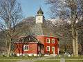
Exterior back
-
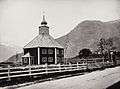
Photo from 1869
See also
References
- Thaule, John Ove; Ubostad, Ingar; Pedersen, Bjørn. 1990. Kyrkjene våre i Ei bok om Rauma, Rauma Kommune. s 207-210
- Grytten menighetsråd. 2004. "Grytten Kirke 175 år"
- ↑ Church Buildings Database accessed February 10, 2014.
- ↑ "Grytten kirke". Kirkesøk: Kirkebyggdatabasen. Retrieved 2013-05-27.
- ↑ "Oversikt over Nåværende Kirker" (in Norwegian). KirkeKonsulenten.no. Retrieved 2013-05-27.
- ↑ Helland, Amund (1911): Norges land og folk. Topografisk-statistisk beskrevet. Romsdals amt. Kristiania: Aschehoug
- ↑ JFL Dreier's picture at DigitaltMuseum
Church of Norway churches in the Indre Romsdal deanery, Møre og Romsdal county, Norway | |||
|---|---|---|---|
| |||