Gulf of Paria
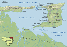
The Gulf of Paria (Spanish: Golfo de Paria) is a 7,800 km2 (3,000 sq mi) shallow (37m at its deepest) semi-enclosed inland sea located between the island of Trinidad (Republic of Trinidad and Tobago) and the east coast of Venezuela. It separates the two countries with as little as 15 km separating them at its narrowest and 120 km at its widest points.The tides within the Gulf are semi-diurnal in nature with a range of approximately 1m.[1] The Gulf of Paria is considered to be one of the best natural harbours on the Atlantic coast of the Americas. The jurisdiction of the Gulf of Paria is split between Trinidad and Tobago and Venezuela with Trinidad and Tobago having control over approximately 2,940 km2 (1,140 sq mi)(37.7%) and Venezuela the remainder(62.3%).[2]
It was originally named the Gulf of the Whale (Spanish: Golfo de la Ballena) by Christopher Columbus, but the 19th Century whaling industry eliminated whales from the area and populations have never recovered. Cartographic sources of the late 18th century repeatedly refer to it as the Sad Gulf (Spanish: Golfo Triste).[3]
In the north, the gulf is connected to the Caribbean Sea through the Dragons' Mouths (Spanish: Bocas del Dragón) between the Paria Peninsula of Venezuela and the Chaguaramas Peninsula of Trinidad. In the south, the gulf is connected to the Atlantic through the Columbus Channel, also known as the Serpent's Mouth (Spanish: Boca del Serpiente), between the Cedros Peninsula and the Orinoco Delta.

Oil and Natural Gas
The Gulf of Paria lies entirely within the broad strike-slip plate boundary zone of the southeastern Caribbean. The structure of the Gulf consists of a complex set of transtensional basins superimposed on a fold-and-thrust belt (Serrania del Interior of eastern Venezuela).[4] The petroleum of Trinidad has been generated by prolific Upper Cretaceous source rocks, time equivalent to the La Luna and Querecual formations in Columbia and Venezuela. These source rocks were then overlain by a thick succession of Paleogene deep water sediments (shales and deep water sandstones) and shallow marine siliciclastic reservoir rocks. The transpression due to the influence of the Caribbean plate created several sub-basins across the Trinidad area; each having distinctive petroleum systems. The hydrocarbon basins in Trinidad are Southern Basin, Columbus Basin, Carupano Basin, Central Range/Darrien Rdige Basin and the Caroni Basin and Gulf of Paria Pull-apart Basin.[5]
The Caroni Basin is a Cenozoic basin bounded to the north by the El Pilar fault zone and the Northern Range fold-thrust belt and to the south by the Central Range fold-thrust belt. Its stratigraphy features a shallowing section from the Miocene which overlies Palaeocene and Lower Cretaceous deep water sediments. The Gulf of Paria is the western offshore extension of the Caroni basin. However its deformation is now extensional due to the right-stepping of the dextral El Pilar fault to the dextral Warm Springs fault. The Los Bajos fault separates the Gulf of Paria from the Southern basin sediments. Natural gas has been discovered in the onshore Caroni basin while in the Gulf of Paria, both oil and gas have been discovered.[6]
Fisheries
The Gulf of Paria is a brackish water body - wet season salinities are below 23 ppt (parts per thousand) with extensive mangroves along the Venezuelan and Trinidadian coastlines. This body of water is basically a shallow sedimentary basin with a maximum depth of 0f 30m (16 fathoms) and a smooth substratum of fine mud with patches of shell debris and sand (Kenny and Bacon, 1981). These conditions lend itself to favourable fisheries conditions and the gulf itself is an important fishery(Heileman and Ramsaroop, 1990). The proximity of the Orinoco Delta to the Gulf suggests that these waters are strongly influenced by fluvial discharges from the Amazon and Orinoco River systems, with the intensity of these discharges varying with the seasons (van Andel and Postma, 1954; Gade, 1961). These rivers are thought to be important effectors of nutrient enhancing upwelling currents on the adjacent continental shelf and sources of primary and secondary productivity for the water around Trinidad, especially in the Gulf (Farbes, 1983). As such, Trinidad supports a more productive and diverse exploitable fish and invertebrate resource base than most of the Eastern Caribbean islands (Agard et al. 1996). The Gulf of Paria is the most important fishing ground for shrimp and finfish in Trinidad.[7]
Port and Logistics
Major ports located within the Gulf of Paria basin include:
- The Port of Port of Spain[8]
- Plipdeco's Port of Point Lisas[9]
- Pedernales in Venezuela's Delta Amacuro state
- Oldendorff Carriers floating facility - Oldendorff Carriers has been operating a floating facility consisting of two cranes, within Trinidadian waters since 2012, for the purpose of transhipment of iron ore from Santana, Brazil to the Middle and Far East.[10]
References
- ↑ https://www.fig.net/resources/proceedings/fig_proceedings/athens/papers/wsh2/WSH2_3_Neale.pdf
- ↑ http://www.state.gov/documents/organization/62002.pdf
- ↑ Mapa de la ysla de Trinidad. Archivo General de Indias. Unidad: Mapas y Planos. Signatura: MP-VENEZUELA, 185. Portal de Archivos Españoles
- ↑ "Chapter 17 Structure of the Gulf of paria pull-apart basin (Eastern Venezuela-Trinidad)". Sedimentary Basins of the World: 477–494. doi:10.1016/S1874-5997(99)80051-3.
- ↑ http://www.energy.gov.tt/wp-content/uploads/2014/02/petroleum_geo.pdf
- ↑ http://www.firstmagazine.com/Krishna Persad.pdf
- ↑ http://www.ema.co.tt/docs/public/comments/NEC_PLSEIP%20SUPPL%20EIA_APP%20XII_090306.pdf
- ↑ "Home - Port Authority of Trinidad and Tobago".
- ↑ "Point Lisas Industrial Port Development Corporation - Home".
- ↑ "OLDENDORFF CARRIERS – Transshipment Operations in Trinidad".
Further reading
- Anthony, Michael (2001). Historical Dictionary of Trinidad and Tobago. Scarecrow Press, Inc. Lanham, Md., and London. ISBN 0-8108-3173-2.
- Stephen Babb, PhD (1997). "Tectonics and Sedimentation of the Gulf of Paria and Northern Basin, Trinidad". The University of Texas at Austin. Archived from the original on 2005-08-02. Retrieved 26 July 2015.
External links
![]() Media related to Gulf of Paria at Wikimedia Commons
Coordinates: 10°23′N 62°21′W / 10.383°N 62.350°W
Media related to Gulf of Paria at Wikimedia Commons
Coordinates: 10°23′N 62°21′W / 10.383°N 62.350°W