Gwalior Metropolitan Region
| Gwalior Metropolitan Region (GMR) ग्वालियर महानगर | |
|---|---|
| Metropolitan Area | |
| Country | India |
| State | Madhya Pradesh |
| Districts | Gwalior Gird |
| Area | |
| • Metro | 730 km2 (280 sq mi) |
| Population (2011 Census) | |
| • Urban | 10,53,505 |
| • Urban density | 4,356/km2 (11,280/sq mi) |
| • Metro | 19,01,395 |
| • Metro density | 3,528/km2 (9,140/sq mi) |
| Time zone | IST (UTC+5.30) |
Gwalior Metropolitan Region (GMR) is a metropolitan area consisting of the metropolitan area of Gwalior and its satellite towns in Madhya Pradesh.
The region has an area of 730 km² (280 sq mi) and with a population of 19,01,395, it is 23rd metropolitan area of India
Municipal Corporations
- Gwalior Municipal Corporation[1]
- Gwalior Development Authority
- Special Area Development Authority (SADA)[2]
The Skyline of Gwalior
Old town
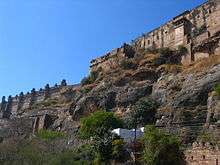
The old town of Gwalior, commonly called Kila Gate is around 1 kilometre (0.62 mi) from Hazira, the largest area in old town, which is of considerable size but irregularly built. It lies at the eastern base of the rock and contains the tomb of the Sufi saints, Khwaja Khanoon and Muhammad Ghaus, erected during the early part of Mughal emperor Akbar I’s reign, and the tomb of Mian Tansen, a great singer and one of the 'Nine Jewels' of Akbar's court. A town called by his name Ghauspura situated near the tomb of Mohaommed Ghaus.reold town consisted of some streets and mohallas which are presumed to be 700- to 800-year-old areas in gwalior which are still backward areas in gwalior due to improper management of new town. these old areas are as follows.
- Koteshwar Temple - this temple is 700-year-old temple of lord shiva whose shivling was on Gwalior Fort but when Mughals conquered the fort they ordered to threw out the shivaling fort. w\When his troops did that, shivaling was automatically established in a field below the fort without any harm. Then Muslim qazi told the emperor not to do harm to shivaling. Then in the late 18th century Scindians built a temple for that shivaling now popularly known as Koteshwar mahadev.
- Baba Kapoor - this place is 500 meters from Ghas Mandi. This place was named because of a famous saint Abdul Gafoor. His mazar is in this area. This area has of 90% of the Muslims in all Gwalior.
- Kashi Naresh ki gali - this a 600-year-old residential street. It was named as Kashi Naresh ki gali because in the 14th century when the emperor of Kashi was defeated in war he was sent to exile. At that time the Gwalior emperor and Kashi's emperor were good friends. When Kashi's emperor told Gwalior's emperor the story, he gave Kahsi an entire street for living. Their family even now resides there in RAJAJI KA BADA.
- Meanings-
- naresh =king = rajaji.
- gali =street in Hindi language.
- bada= big area.
All these areas are considered to be very important areas in historical point of view. Many times many historical coins, jewellery, arms etc. are found when a people renovate houses. The town has a museum situated in the Gujari Mahal.
Lashkar Gwalior/Lashkar Subcity
The name of Lashkar is a Persian word meaning 'army' or 'camp', as this was originally the camp, and later the permanent capital, of the Scindia dynasty of Gwalior state. Lashkar was the capital of Madhya Bharat from 1950 to 1956.
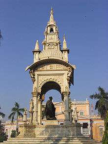
Jayaji Chowk is the central focus of Lashkar, with a large square, a former opera house, banks, tea, coffee and juice stands and a municipal market building. Thriving bazaars surround the chowk. Many jewellery shops are situated near Jayaji Chowk, also known as Maharaj Bada. A source of water for the city is Tighra Dam, built on the Saank river 20 km to the north. The Gajra Raja Medical College, founded in 1946 by the Maharaja Jiwaji Rao Scindia and the Maharani Vijayaraje Scindia, is situated in Lashkar on Palace Road, near Katora Taal, together with a group of many hospitals. Jai Vilas Palace, patterned on the French palace of Versailles is located here.
Morar
Morar, formerly a separate town, lies 5 kilometres (3.1 mi) east of the old city. It was formerly a British military cantonment. Morar is generally considered a rural farming town. The area is known as the "green part" of Gwalior because much of the area is still rural.
Morar was the scene of the most serious uprising in Central India. On 1 June 1858, Jayajirao Scindia led his forces to Morar to fight a rebel army led by Tatya Tope, Rani Lakshmibai and Rao Sahib. This army had 7,000 infantry, 4,000 cavalry and 12 guns while he had only 1,500 cavalry, his bodyguard of 600 men and 8 guns. In this attack, the rebel cavalry took the guns and most of the Gwalior forces except the bodyguard went over to the rebels (some deserted). The Maharaja and the remainder fled without stopping until they reached the British garrison at Agra.[3] By 1900 it had become a centre for local trade and had an important training industry, with a population of 19,179 in 1901.
One of the sun temples of India is situated in Morar at Residency Road. This Sun Temple was built by the Aditya Birla Trust.
The cantonment area makes up a large area of Morar which contains official residences for the Indian Army. It has many canteens for Army personnel. Saint Paul's School and Pragati Vidyapeeth School are nearby. There is an air force base in the Pinto Park region.
Thatipur
Thatipur is said to have got its name from State Army Unit 34, which once resided there. Gandhi Road divides Thatipur into two areas. Morar at one end of the road and Balwant Nagar on the other. It primarily consists of Darpan Colony, Madhav Rao Scindhiya Enclave, the government blocks, Vivek Nagar, and Suresh Nagar. Places of note are the Dwarikadhish Mandir, Bhagwan colony, Tomar building, Chauhan Pyaau (The Chauhan's family),"Kaurav bhavan" (residence of Thakur B. M. S. Kaurav), Galla Kothar, Ramkrishna Aashram, Saraswati Nagar, Govindpuri, Gayatri Vihar, Shakti Vihar, Shakuntalapuri, Dushyant Nagar, Shanti Vihar, and Mayur market along with Sai Baba Mandir in Shakti Vihar Colony.
Gwalior West
The Counter Magnet City or Gwalior West is a project under National Capital Territory of Delhi to stop migration and release the population load on Delhi. Gwalior West is managed by the Special Area Development Authority (SADA).
Towns
- Morar
- Lashkar
- Thatipur
- City centre
- Malanpur
- Banmore
- Sithouli
- Gwalior West
- City Centre Extn
- Deendayal Nagar
Industrial Area
- Malanpur Industrial Area
- Maharajpura Industrial Area
- Banmore Industrial Area
- Birla Nagar Industrial Area
- Sithouli Industrial Area
Rivers
Codes
- Postal Codes : 474 001 to 474 055
- Telephone Code : +91 (751),+91 (75324),+91 (7539)
- Vehicle : MP 07, MP 30, MP 06
See also
References
- ↑ http://gwaliormunicipalcorporation.org Gwalior Municipal Corporation
- ↑ http://ncrgwalior.com Special Area Development Authority
- ↑ Edwardes, Michael (1975) Red Year. London: Sphere Books; p. 124