Gyeryongsan National Park
This article is about the national park. For the mountain where the park is located, see Gyeryongsan. For the mountain in South Gyeongsang Province, see Gyeryongsan (South Gyeongsang Province).
| Gyeryongsan National Park | |
|---|---|
| 계룡산국립공원, 鷄龍山國立公園 | |
|
IUCN category II (national park) | |
|
View of the mountain Gyeryongsan | |
| Location | Chungcheongnam-do, South Korea |
| Nearest city | Daejeon |
| Coordinates | 36°21′40″N 127°12′40″E / 36.361°N 127.211°E[1]Coordinates: 36°21′40″N 127°12′40″E / 36.361°N 127.211°E[2] |
| Area | 64.71 km2 (24.98 sq mi) |
| Established | 31 December 1968 |
| Governing body | Korea National Park Service |
| http://english.knps.or.kr/Knp/Gyeryongsan/Intro/Introduction.aspx | |

Taebaeksan
The twenty-one national parks of South Korea.
Land-based parks are in red and marine parks are in blue.
Land-based parks are in red and marine parks are in blue.
Gyeryongsan National Park (Korean: 계룡산국립공원, 鷄龍山國立公園) is one of 20 national parks in South Korea. It was designated as a national park in 1968, as the second park in the country.[3] It covers an area of 64.71 km2 (24.98 sq mi).[3] One part of Gyeryongsan, a 845-metre-high (2,772 ft) mountain, is located in the park.
The park is home to a total of 1,121 plant species, 1,867 insect species and 645 animal species. Among the animals eleven are endangered, including Otter, Marten, Common buzzard, and Black woodpecker.[3]
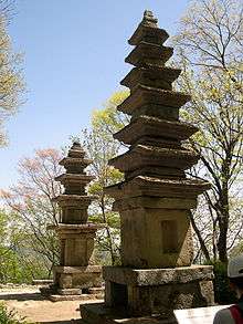
Seoktap near Gapsa Temple, Gyeryeongsang Park
References
- ↑ "Gyeryongsan National Park". protectedplanet.net.
- ↑ "Gyeryongsan National Park". protectedplanet.net.
- 1 2 3 "Gyeryongsan: Intro". Korea National Park Service. Retrieved 18 September 2010.
External links
| Wikimedia Commons has media related to Gyeryongsan National Park. |
This article is issued from Wikipedia - version of the 11/19/2016. The text is available under the Creative Commons Attribution/Share Alike but additional terms may apply for the media files.