Gagarin, Smolensk Oblast
| Gagarin (English) Гагарин (Russian) | |
|---|---|
| - Town[1] - | |
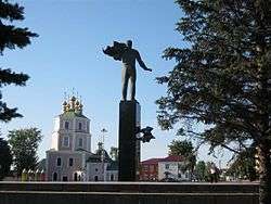 Monument to Yuri Gagarin in the town | |
.svg.png) Location of Smolensk Oblast in Russia | |
 Gagarin | |
|
| |
 |
|
|
| |
| Administrative status (as of February 2014) | |
| Country | Russia |
| Federal subject | Smolensk Oblast[1] |
| Administrative district | Gagarinsky District[1] |
| Urban settlement | Gagarinskoye[1] |
| Administrative center of | Gagarinsky District,[1] Gagarinskoye Urban Settlement[1] |
| Municipal status (as of May 2013) | |
| Municipal district | Gagarinsky Municipal District[2] |
| Urban settlement | Gagarinskoye Urban Settlement[2] |
| Administrative center of | Gagarinsky Municipal District,[2] Gagarinskoye Urban Settlement[3] |
| Mayor[4] | Andrey Puzikov (acting)[4] |
| Statistics | |
| Area (urban settlement) (February 2014) | 17.93 km2 (6.92 sq mi)[1] |
| Population (2010 Census) | 31,721 inhabitants[5] |
| Density | 1,769/km2 (4,580/sq mi)[6] |
| Time zone | MSK (UTC+03:00)[7] |
| Founded | 1718[8] |
| Town status since | 1776[8] |
| Previous names | Gzhatsk (until 1968) |
| Postal code(s)[9] | 215010, 215059 |
| Dialing code(s) | +7 48135 |
|
| |
| Gagarin on Wikimedia Commons | |
Gagarin (Russian: Гага́рин), known until 1968 as Gzhatsk (Гжатск), is a town and the administrative center of Gagarinsky District of Smolensk Oblast, Russia, located on the Gzhat River, 240 kilometers (150 mi) northeast of Smolensk, the administrative center of the oblast. Population: 31,721 (2010 Census);[5] 28,789 (2002 Census);[10] 28,867 (1989 Census).[11]
The town's former name is from that of the Gzhat River, which is of Baltic origin (cf. Old Prussian gudde, meaning "forest").[12]
History
In 1718, a village on the territory of modern Gagarin was transformed by a decree of Peter the Great to a transshipment landing stage (called Gzhatsky landing stage).[8] From the mid-18th century, Gzhatsk was a sloboda, and in 1776, by a decree by Catherine the Great, it was granted uyezd town status[8] and a coat of arms showing "a barge loaded with bread ready for departure, on a field argent", meaning that the town was a good landing stage for grain.
The town was built at the crossing of the Moscow road (east-west) and the Smolensk road (north-south, paralleling the river). By the plan of 1773, it was laid out in triangular form. One part paralleled the Gzhat River, another—the road to Moscow, and the base of the triangle connected them.
On August 29, 1812, in the village of Tsaryovo-Zaymishche near Gzhatsk, Mikhail Kutuzov accepted command of the Russian army. On the day of Napoleon's invasion, the town was set on fire and burned for several days. It was near Gzhatsk where Denis Davydov's guerrilla group started to operate. Russian troops entered the town again on November 2, 1812. When the town was rebuilt in 1817, the former regular layout was basically kept.
On November 13 [O.S. October 31], 1917, Soviet power was proclaimed in Gzhatsk and its uyezd. A year later, there was a counterrevolutionary insurrection.
During World War II, the town housed a flax factory, a sawmill, a brickyard, a roller-mill, a bakehouse complex, a weaving factory, a power station, and a number of guilds. In the course of the war, Gzhatsk was occupied by the Germans October 9, 1941 to March 6, 1943.
In 1968, the town was renamed Gagarin in honor of the first person to travel into space, Yuri Gagarin, who was born in 1934 in the nearby village of Klushino.
Administrative and municipal status
Within the framework of administrative divisions, Gagarin serves as the administrative center of Gagarinsky District.[1] As an administrative division, it is, together with one rural locality (the settlement of Trufany), incorporated within Gagarinsky District as Gagarinskoye Urban Settlement.[1] As a municipal division, this administrative unit also has urban settlement status and is a part of Gagarinsky Municipal District.[2]
Twin towns and sister cities
Gagarin is twinned with:
References
Notes
- 1 2 3 4 5 6 7 8 9 Resolution #261
- 1 2 3 4 Law #129-z
- ↑ Федеральная служба государственной статистики. Федеральное агентство по технологическому регулированию и метрологии. №ОК 033-2013 1 января 2014 г. «Общероссийский классификатор территорий муниципальных образований. Код 66 608 101». (Federal State Statistics Service. Federal Agency on Technological Regulation and Metrology. #OK 033-2013 January 1, 2014 Russian Classification of Territories of Municipal Formations. Code 66 608 101. ).
- 1 2 Official website of Gagarin. Andrey Yuryevich Puzikov, acting mayor of Gagarin (Russian)
- 1 2 Russian Federal State Statistics Service (2011). "Всероссийская перепись населения 2010 года. Том 1" [2010 All-Russian Population Census, vol. 1]. Всероссийская перепись населения 2010 года (2010 All-Russia Population Census) (in Russian). Federal State Statistics Service. Retrieved June 29, 2012.
- ↑ The value of density was calculated automatically by dividing the 2010 Census population by the area specified in the infobox. Please note that this value may not be accurate as the area specified in the infobox does not necessarily correspond to the area of the entity proper or is reported for the same year as the population.
- ↑ Правительство Российской Федерации. Федеральный закон №107-ФЗ от 3 июня 2011 г. «Об исчислении времени», в ред. Федерального закона №271-ФЗ от 03 июля 2016 г. «О внесении изменений в Федеральный закон "Об исчислении времени"». Вступил в силу по истечении шестидесяти дней после дня официального опубликования (6 августа 2011 г.). Опубликован: "Российская газета", №120, 6 июня 2011 г. (Government of the Russian Federation. Federal Law #107-FZ of June 31, 2011 On Calculating Time, as amended by the Federal Law #271-FZ of July 03, 2016 On Amending Federal Law "On Calculating Time". Effective as of after sixty days following the day of the official publication.).
- 1 2 3 4 Энциклопедия Города России. Moscow: Большая Российская Энциклопедия. 2003. p. 102. ISBN 5-7107-7399-9.
- ↑ Почта России. Информационно-вычислительный центр ОАСУ РПО. (Russian Post). Поиск объектов почтовой связи (Postal Objects Search) (Russian)
- ↑ Russian Federal State Statistics Service (May 21, 2004). "Численность населения России, субъектов Российской Федерации в составе федеральных округов, районов, городских поселений, сельских населённых пунктов – районных центров и сельских населённых пунктов с населением 3 тысячи и более человек" [Population of Russia, Its Federal Districts, Federal Subjects, Districts, Urban Localities, Rural Localities—Administrative Centers, and Rural Localities with Population of Over 3,000] (XLS). Всероссийская перепись населения 2002 года [All-Russia Population Census of 2002] (in Russian). Retrieved August 9, 2014.
- ↑ Demoscope Weekly (1989). "Всесоюзная перепись населения 1989 г. Численность наличного населения союзных и автономных республик, автономных областей и округов, краёв, областей, районов, городских поселений и сёл-райцентров" [All Union Population Census of 1989: Present Population of Union and Autonomous Republics, Autonomous Oblasts and Okrugs, Krais, Oblasts, Districts, Urban Settlements, and Villages Serving as District Administrative Centers]. Всесоюзная перепись населения 1989 года [All-Union Population Census of 1989] (in Russian). Институт демографии Национального исследовательского университета: Высшая школа экономики [Institute of Demography at the National Research University: Higher School of Economics]. Retrieved August 9, 2014.
- ↑ Е. М. Поспелов. Географические названия мира (Москва, 1998), стр. 110.
Sources
- Администрация Смоленской области. Постановление №261 от 30 апреля 2008 г. «Об утверждении реестра административно-территориальных единиц и территориальных единиц Смоленской области», в ред. Постановления №464 от 27 июня 2014 г. «О внесении изменений в реестр административно-территориальных единиц и территориальных единиц Смоленской области». Опубликован: База данных "Консультант-плюс". (Administration of Smolensk Oblast. Resolution #261 of April 30, 2008 On the Adoption of the Registry of the Administrative-Territorial Units and Territorial Units of Smolensk Oblast, as amended by the Resolution #464 of June 27, 2014 On Amending the Registry of the Administrative-Territorial Units and Territorial Units of Smolensk Oblast. ).
- Смоленская областная Дума. Закон №129-з от 28 декабря 2004 г. «О наделении статусом муниципального района муниципального образования "Гагаринский район" Смоленской области, об установлении границ муниципальных образований, территории которых входят в его состав, и наделении их соответствующим статусом», в ред. Закона №51-з от 30 мая 2013 г. «О внесении изменений в отдельные областные Законы». Вступил в силу со дня официального опубликования. Опубликован: "Вестник Смоленской областной Думы и Администрации Смоленской области", №14, часть I, стр. 98, 30 декабря 2004 г. (Smolensk Oblast Duma. Law #129-z of December 28, 2004 On Granting the Status of the Municipal District to the Municipal Formation of "Gagarinsky District" of Smolensk Oblast, on Establishing the Borders of the Municipal Formations the Territories of Which It Comprises, and on Granting Them Appropriate Status, as amended by the Law #51-z of May 30, 2013 On Amending Various Oblast Laws. Effective as of the official publication date.).
| Cities and towns | |||
|---|---|---|---|
| Districts | |||