Rudnyansky District, Smolensk Oblast
.png)
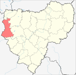
Rudnyansky District (Russian: Рудня́нский райо́н) is an administrative[1] and municipal[3] district (raion), one of the twenty-five in Smolensk Oblast, Russia. It is located in the west and northwest of the oblast and borders with Velizhsky District in the north, Demidovsky District in the northeast, Smolensky District in the east, Krasnensky District in the south, and with Vitebsk and Liozna Districts of Vitebsk Region of Belarus in the west. The area of the district is 2,111.41 square kilometers (815.22 sq mi).[1] Its administrative center is the town of Rudnya.[1] Population: 25,244 (2010 Census);[4] 28,037 (2002 Census);[7] 34,724 (1989 Census).[8] The population of Rudnya accounts for 39.7% of the district's total population.[4]
Geography
The area of the district is elongated north to south and is split between grainage basing of the Western Dvina (north) and the Dnieper (south). The biggest tributary of the Wester Dvina within the district is the Kasplya River, which crosses the northern part of the district from east to west; its major left tributary is the Rutovech River. Rivers in the southern part of the district flow to the Dnieper. The largest tributary of the Dnieper in the district is the Malaya Berezina River.
History
The area was settled in the prehistory, and there are multiple archaeological sites in the district. Rudnya (as the settlement of Rodnya) is first mentioned in 1363 since the lands were occupied by Andrei of Polotsk and included in the Principality of Smolensk.[9] Since 1404, it belonged to the Grand Duchy of Lithuania, then to Poland, which was confirmed in 1667 by the Truce of Andrusovo.[10]
After the First Partition of Poland in 1772 the area was included into newly established Babinovichsky Uyezd of Mogilev Governorate. In 1840, the uyezd was abolished and merged into Orshansky Uyezd of the same governorate.[10] In 1919, Mogilev Governorate was abolished, and Orshansky Uyezd was included into Gomel Governorate. In 1920, the uyezd was included into Vitebsk Governorate, and shortly the area was transferred to Smolensky Uyezd of Smolensk Governorate. In 1926, Rudnya was granted the town status.[10]
The area was south of the Pale of Settlement, and Jews were allowed to settle here. In particular, the village of Lyubavichi gave the name to Chabad-Lubavitch branch of Hassidism. Virtually all Jews who stayed until World War II were massacred in 1941 during the Holocaust.
On 12 July 1929, governorates and uyezds were abolished, and Rudnyansky District with the administrative center in Rudnya was established. The district belonged to Smolensk Okrug of Western Oblast. On August 1, 1930 the okrugs were abolished, and the districts were subordinated directly to the oblast. On 27 September 1937 Western Oblast was abolished and split between Oryol and Smolensk Oblasts. Rudnyansky District was transferred to Smolensk Oblast. Between 1941 and September 1943, during WWII, the district was occupied by German troops.[9][11]
On 12 July 1929, Kasplyansky District with the administrative center in the selo of Kasplya was established as well in the areas which previously belonged to Demidovsky, Dukhovshchinsky, and Smolensky Uyezds. The district belonged to Smolensk Okrug of Western Oblast. On 1 February 1932, the district was abolished and split between Demidovsky, Dukhovshchinsky, Rudnyansky, and Smolensky Districts. In 1938, it was re-established; it belonged to Smolensk Oblast. In 1961, Kasplyansky District was abolished and merged into Smolensky District.[11]
Another district established on 12 July 1929 was Ponizovsky District with the administrative center in the selo of Ponizovye. It was created in the areas which previously belonged to Demidovsky Uyezd. The district belonged to Smolensk Okrug of Western Oblast. In 1930, the district was abolished and split between Demidovsky and Rudnyansky Districts. In 1935, it was re-established, and in 1937, it was transferred to Smolensk Oblast. In 1961, Ponizovsky District was abolished and split between Demidovsky and Rudnyansky Districts.[11]
Economy
Industry
80% of the industrial production in the district is produced by food industry. There is also production of shoes and of doors and windows.[12]
Agriculture
The main agricultural specialization of the district is cattle breeding for meat and milk production. There is also growing of flax.[13]
Trasportation
The railway connecting Smolensk with Vitebsk and further with Daugavpils crosses the southern part of the district. Rudnya is the largest railway station.
The R120 highway connecting Smolensk with the state border between Russia and Belarus, and continuing across the border to Vitebsk, runs through the district, passing Rudnya. The R130 highway connects Rudnya to Demidov.
Culture and recreation

The district contains sixteen cultural heritage monuments of federal significance, one of them in Rudnya, and additionally ninety-seven objects classified as cultural and historical heritage of local significance (three of them in Rudnya). The federally protected monuments are the monument to the first Katyusha rocket launcher military usage during World War II in Rudnya, as well as fifteen archaeological sites.[14]
In Rudnya, there is a history museum[15] and a museum-house of Mikhail Yegorov.[16] The latter is a subdivision of Smolensk State Museum Reserve. Yegorov, who was born close to Rudnya, was one of the two Soviet soldiers who raised a flag over the Reichstag on 2 May 1945, after the Battle of Berlin.
References
Notes
- 1 2 3 4 5 6 7 8 Resolution #261
- ↑ The count of urban-type settlements may include the work settlements, the resort settlements, the suburban (dacha) settlements, as well as urban-type settlements proper.
- 1 2 3 Law #76-z
- 1 2 3 Russian Federal State Statistics Service (2011). "Всероссийская перепись населения 2010 года. Том 1" [2010 All-Russian Population Census, vol. 1]. Всероссийская перепись населения 2010 года (2010 All-Russia Population Census) (in Russian). Federal State Statistics Service. Retrieved June 29, 2012.
- ↑ The value of density was calculated automatically by dividing the 2010 Census population by the area specified in the infobox. Please note that this value is only approximate as the area specified in the infobox does not necessarily correspond to the area of the entity proper or is reported for the same year as the population.
- ↑ Правительство Российской Федерации. Федеральный закон №107-ФЗ от 3 июня 2011 г. «Об исчислении времени», в ред. Федерального закона №271-ФЗ от 03 июля 2016 г. «О внесении изменений в Федеральный закон "Об исчислении времени"». Вступил в силу по истечении шестидесяти дней после дня официального опубликования (6 августа 2011 г.). Опубликован: "Российская газета", №120, 6 июня 2011 г. (Government of the Russian Federation. Federal Law #107-FZ of June 31, 2011 On Calculating Time, as amended by the Federal Law #271-FZ of July 03, 2016 On Amending Federal Law "On Calculating Time". Effective as of after sixty days following the day of the official publication.).
- ↑ Russian Federal State Statistics Service (May 21, 2004). "Численность населения России, субъектов Российской Федерации в составе федеральных округов, районов, городских поселений, сельских населённых пунктов – районных центров и сельских населённых пунктов с населением 3 тысячи и более человек" [Population of Russia, Its Federal Districts, Federal Subjects, Districts, Urban Localities, Rural Localities—Administrative Centers, and Rural Localities with Population of Over 3,000] (XLS). Всероссийская перепись населения 2002 года [All-Russia Population Census of 2002] (in Russian). Retrieved August 9, 2014.
- ↑ Demoscope Weekly (1989). "Всесоюзная перепись населения 1989 г. Численность наличного населения союзных и автономных республик, автономных областей и округов, краёв, областей, районов, городских поселений и сёл-райцентров" [All Union Population Census of 1989: Present Population of Union and Autonomous Republics, Autonomous Oblasts and Okrugs, Krais, Oblasts, Districts, Urban Settlements, and Villages Serving as District Administrative Centers]. Всесоюзная перепись населения 1989 года [All-Union Population Census of 1989] (in Russian). Институт демографии Национального исследовательского университета: Высшая школа экономики [Institute of Demography at the National Research University: Higher School of Economics]. Retrieved August 9, 2014.
- 1 2 "История" Check
|url=value (help) (in Russian). Rudnyansky District Administration. Retrieved 10 October 2016. - 1 2 3 "Герб Руднянского района" (in Russian). City of Roslavl. Retrieved 10 October 2016.
- 1 2 3 Борис Парфенов; Ольга Хоренженкова. "К истории формирования Смоленской области" (in Russian). Смоленск. Retrieved 18 June 2016.
- ↑ "Промышленность" Check
|url=value (help) (in Russian). Rudnyansky District Administration. Retrieved 2 October 2016. - ↑ "Инвестиционный паспорт Руднянского района" Check
|url=value (help) (in Russian). Rudnyansky District Administration. Retrieved 3 October 2016. - ↑ Памятники истории и культуры народов Российской Федерации (in Russian). Russian Ministry of Culture. Retrieved 2 June 2016.
- ↑ "Муниципальное бюджетное учреждение культуры Руднянский исторический музей" (in Russian). Rudnya History Museum. Retrieved 7 October 2016.
- ↑ "Дом-музей М.А.Егорова" (in Russian). Смоленский государственный музей-заповедник. Retrieved 7 October 2016.
Sources
- Администрация Смоленской области. Постановление №261 от 30 апреля 2008 г. «Об утверждении реестра административно-территориальных единиц и территориальных единиц Смоленской области», в ред. Постановления №464 от 27 июня 2014 г. «О внесении изменений в реестр административно-территориальных единиц и территориальных единиц Смоленской области». Опубликован: База данных "Консультант-плюс". (Administration of Smolensk Oblast. Resolution #261 of April 30, 2008 On the Adoption of the Registry of the Administrative-Territorial Units and Territorial Units of Smolensk Oblast, as amended by the Resolution #464 of June 27, 2014 On Amending the Registry of the Administrative-Territorial Units and Territorial Units of Smolensk Oblast. ).
- Смоленская областная Дума. Закон №76-з от 1 декабря 2004 г. «О наделении статусом муниципального района муниципального образования Руднянский район Смоленской области, об установлении границ муниципальных образований, территории которых входят в его состав, и наделении их соответствующим статусом», в ред. Закона №111-з от 23 ноября 2011 г. «О внесении изменений в областной Закон "О наделении статусом муниципального района муниципального образования Руднянский район Смоленской области, об установлении границ муниципальных образований, территории которых входят в его состав, и наделении их соответствующим статусом"». Вступил в силу со дня официального опубликования. Опубликован: "Вестник Смоленской областной Думы и Администрации Смоленской области", №12, часть II, стр. 104, 5 декабря 2004 г. (Smolensk Oblast Duma. Law #76-z of December 1, 2004 On Granting the Status of the Municipal District to the Municipal Formation of Rudnyansky District of Smolensk Oblast, on Establishing the Borders of the Municipal Formations Whose Territories It Comprises, and on Granting Them Appropriate Status, as amended by the Law #111-z of November 23, 2011 On Amending the Oblast Law "On Granting the Status of the Municipal District to the Municipal Formation of Rudnyansky District of Smolensk Oblast, on Establishing the Borders of the Municipal Formations Whose Territories It Comprises, and on Granting Them Appropriate Status". Effective as of the official publication date.).
| Cities and towns | |||
|---|---|---|---|
| Districts | |||