Hackensack River
| Hackensack River | |
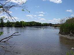 A view of the Hackensack River taken from the shore in Teaneck at low tide | |
| Country | United States |
|---|---|
| States | New Jersey, New York |
| Counties | Hudson, NJ, Bergen, NJ, Rockland, NY |
| City | Hackensack, NJ |
| Source | |
| - location | West Haverstraw, Rockland County, New York, USA |
| - elevation | 120 ft (37 m) |
| - coordinates | 41°11′00″N 73°59′24″W / 41.18333°N 73.99000°W |
| Mouth | Newark Bay |
| - elevation | 0 ft (0 m) |
| - coordinates | 40°42′55″N 74°06′42″W / 40.71528°N 74.11167°WCoordinates: 40°42′55″N 74°06′42″W / 40.71528°N 74.11167°W |
| Length | 54 mi (87 km) |
| Discharge | for New Milford, NJ |
| - average | 173 cu ft/s (5 m3/s) |
| - max | 880 cu ft/s (25 m3/s) |
| - min | 0 cu ft/s (0 m3/s) |
| Discharge elsewhere (average) | |
| - West Nyack, NY | 58 cu ft/s (2 m3/s) |
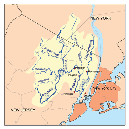 The Passaic and Hackensack watersheds | |
The Hackensack River is a river, approximately 45 miles (72 km) long, in the U.S. states of New York and New Jersey, emptying into Newark Bay, a back chamber of New York Harbor. The watershed of the river includes part of the suburban area outside New York City just west of the lower Hudson River, which it roughly parallels, separated from it by the New Jersey Palisades. It also flows through and drains the New Jersey Meadowlands. The lower river, which is navigable as far as the city of Hackensack,[1] is heavily industrialized and forms a commercial extension of Newark Bay. Once believed to be among the most polluted water courses in the United States, it had staged a modest revival by the late 2000s.
Description
The Hackensack River rises in southeastern New York, in Rockland County, in the Sweet Swamp, just west of the Hudson River and approximately 1 mi (1.6 km) south of West Haverstraw. It flows briefly southeast, into the Lake DeForest reservoir, separated from the Hudson by less than 3 mi (5 km). South of the dam, it then flows south, diverging from the Hudson. Just across the New Jersey state line, in northern Bergen County, it is impounded to form the reservoir Lake Tappan near River Vale.
South of Lake Tappan, it flows in a meandering course southward through the suburban communities of New Jersey. Near Oradell, it is impounded to form Oradell Reservoir, where it is joined by several streams, including the Dwars Kill, the Cherry Brook and Pascack Brook. Van Buskirk Island, a man-made island and site of the New Milford Plant of the Hackensack Water Company, lies in this area. South of the reservoir, it flows past River Edge, Hackensack, Teaneck, Bogota, and Ridgefield Park, once again approaching within 3 mi (5 km) of the Hudson, and separated from it by the ridge of the Palisades.
At Little Ferry, it is joined by the broad Overpeck Creek, then flows southward, widening in a broad meandering tidal estuary through the Meadowlands, forming extensive side streams and wetlands. South of North Bergen, it forms the boundary between Bergen County to the west and Hudson County to the east. Opposite Secaucus it is joined by Berrys Creek, then flows past the western edge of Jersey City, which overlooks the river's valley from the ridge of the Palisades, before forming Newark Bay at its confluence with the Passaic River between Jersey City and Kearny.
As it flows through the Meadowlands it is traversed by numerous rail and road bridges.
History

The name of the river comes from the Lenape word Achinigeu-hach, or Ackingsah-sack, meaning flat confluence of streams or stony ground.[2] Conflicts with the Lenape prevented the early Dutch settlers of the New Netherland colony from expanding westward into the valley into late in the 17th century. The river furnished both the Native Americans and the European settlers with abundant runs of herring, shad and striped bass.
In the colonial era, the river and the surrounding Meadowlands presented a formidable difficulty in transportation and communication. The wetlands helped allow the escape of the Continental Army under George Washington in 1776 after several defeats at the hands of the British army on the east side of the Hudson. It later served as a protective barrier that allowed Washington's army to encamp in the nearby hills near Morristown.
For two centuries, the river suffered from extremely severe pollution. The construction of the Oradell Reservoir dam in 1921 essentially changed the lower river from a free-flowing stream into a brackish estuary, allowing the encroachment of marine species. By the 1960s, much of the lower river was essentially a turbid hypoxic dead zone, with only the hardiest of species such as the mummichog able to survive in its waters. Berrys Creek was once thought to be the most polluted stream in the United States.
The river recovered somewhat by the late 2000s following the decline in manufacturing in the area, as well as from enforcement of Clean Water Act regulations and from the efforts of local conservancy groups. Recreational fishing has staged a modest comeback, although catch and release may be advisable, as there are continuing health advisories against the consumption of fish caught in the river. Urban runoff pollution, municipal sewage discharges from sanitary sewer overflows and combined sewer overflows, and runoff from hazardous waste sites continue to impair the river's water quality.[3][4]
The future of the wetlands around the lower river has been an ongoing controversy between development and preservation groups in recent decades. The controversial Hackensack Meadowlands Development Commission (now the New Jersey Meadowlands Commission) was established by the state in 1968 to manage development and habitat preservation.[5]
Tributaries
New Jersey
- Berrys Creek
- Bashes Creek
- Cherry Brook
- Moonachie Creek
- Mill Creek
- Cromakill Creek
- Bellmans Creek
- Losen Slote
- Overpeck Creek
- Coles Brook
- French Brook
- Hirshfeld Brook
- Dwars Kill
- Tappan Run
- Pascack Brook
- Holdrum Brook
- Hillsdale Brook
- Cherry Brook
New York
- Nauraushaun Brook Nanuet, New York
- East Branch Hackensack River
- Toms Creek
- West Branch Hackensack River
See also
- List of New Jersey rivers
- List of New York rivers
- List of crossings of the Hackensack River
- Little Ferry Seaplane Base
- Hackensack RiverWalk
References
- ↑ "117.723 Hackensack River", Title 33: Navigation and Navigable Waters Part 117—Drawbridge Operations Regulations, US Government Printing Office, October 20, 2012, retrieved 2012-10-20
- ↑ Bergen County Hist Society: Indigenous People of Bergen County
- ↑ Wright, Jim. "Hackensack River is getting cleaner." The Record. August 26, 2007.
- ↑ New Jersey Department of Environmental Protection. Trenton, NJ. "Watershed Management Area 5 Factsheet." Bureau of Watershed Planning. July 17, 2007.
- ↑ New Jersey Meadowlands Commission, Lyndhurst, NJ. "Wetlands Sites in the Meadowlands." Accessed 2009-02-27.
External links
| Wikimedia Commons has media related to Hackensack River. |
- Bergen SWAN - Watershed Protection Group
- Hackensack Riverkeeper - Environmental organization
- Hackensack River tides - Fairleigh Dickinson University
- Hackensack River bridges
- Wild New Jersey: Fishes of the Hackensack River
- Friends of the Hackensack River Greenway through Teaneck
- New Jersey Meadowlands Commission
- Meadowlands Environment Center
- Meadowlands Environmental Research Institute (MERI)
- New Jersey Naval Museum Home of the W.W. II Submarine USS Ling (SS-297)
- USS Ling Photos on board the Submarine USS Ling SS-297
- NOAA Chart 12337, Passaic and Hackensack Rivers
- U.S. Geological Survey: NJ stream gaging stations