Hamlyn Heights, Victoria
| Hamlyn Heights Geelong, Victoria | |||||||||||||
|---|---|---|---|---|---|---|---|---|---|---|---|---|---|
 Golden ash trees on Langibanool avenue Hamlyn Heights Geelong, Victoria, Australia | |||||||||||||
 Hamlyn Heights | |||||||||||||
| Coordinates | 38°07′S 144°19′E / 38.12°S 144.32°ECoordinates: 38°07′S 144°19′E / 38.12°S 144.32°E | ||||||||||||
| Population | 6,075 (2011 census)[1] | ||||||||||||
| Postcode(s) | 3215 | ||||||||||||
| LGA(s) | City of Greater Geelong | ||||||||||||
| State electorate(s) | Lara | ||||||||||||
| Federal Division(s) | Corio | ||||||||||||
| |||||||||||||
Hamlyn Heights is a residential suburb of Geelong, Victoria, Australia. It located to the west of the city on hills that overlook Corio Bay. At the 2011 census, Hamlyn Heights had a population of 6,075.[1]
The suburb boundaries are Church St, Ballarat Rd, Moorabool River and two unmarked boundaries extending between Church St to Moorabool River and between Moorabool River and Ballarat Rd.
Hamlyn Heights has two retail areas. A large shopping strip is located in Vines Rd. The Post Office opened here on 2 February 1959 it is known as Vines Road, Geelong.[2] A small group of shops also exist in Fairlie St.
Education and Recreation
Hamlyn Heights has two primary schools, Herne Hill Primary School & Hamlyn Banks Primary School (created in the late 1990s by a merger between Hamlyn Heights Primary School and Lovely Banks Primary School) as well as Western Heights Secondary College.
Hamlyn Park is home to the Bell Park Sport and Recreation Club which has teams in the local football and netball associations. It is also home to the Hamlyn Park Tennis Club, Geelong Ballroom Dance Club and the 1st Hamlyn Heights Scout Group.
Heritage listed sites
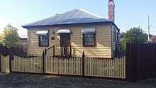
- 21 Brewongle Avenue [3]
References
- 1 2 Australian Bureau of Statistics (31 October 2012). "Hamlyn Heights (State Suburb)". 2011 Census QuickStats. Retrieved 11 December 2014.
- ↑ Premier Postal History, Post Office List, retrieved 2008-04-11
- ↑ "c1854 timber house". Victorian Heritage Register. . Retrieved 2016-09-19.