Breamlea, Victoria
| Breamlea Victoria | |||||||||||||
|---|---|---|---|---|---|---|---|---|---|---|---|---|---|
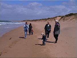 Main beach at Breamlea | |||||||||||||
 Breamlea | |||||||||||||
| Coordinates | 38°18′S 144°23′E / 38.300°S 144.383°ECoordinates: 38°18′S 144°23′E / 38.300°S 144.383°E | ||||||||||||
| Postcode(s) | 3227 | ||||||||||||
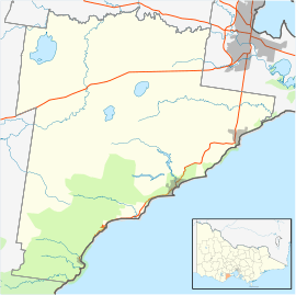
| Location | |||||||||||||
| LGA(s) | |||||||||||||
| State electorate(s) | South Barwon | ||||||||||||
| Federal Division(s) | Corangamite | ||||||||||||
| |||||||||||||
Breamlea, Victoria, Australia, is a secluded seaside hamlet located on the south coast of the Bellarine Peninsula, 18 kilometres south of Geelong and halfway between Barwon Heads and Torquay. It is divided between the City of Greater Geelong and the Surf Coast Shire. In the 2011 census, Breamlea and surrounding areas (including the eastern half of Connewarre and a rural portion of Barwon Heads) had a population of 444 people.[1]
Geography
Breamlea is nestled in the sand dunes between Thomsons Creek and the beach. The nearest township to Breamlea is Connewarre.
Thomsons Creek, also known as Bream Creek, runs through a natural network of reedy canals and widens before it enters Buckleys Bay. At the mouth of the creek is Point Impossible which is a well-known longboard surfing break.
The patrolled surf beach at Breamlea is called Bancoora, and is the closest surf beach to Melbourne. The beach was named after the steamship SS Bancoora that ran aground on there in 1881.[2] Other non-patrolled beaches along this stretch of coast are not heavily used and are often empty.
History
The area was once populated by the Mon Mart Clan of Wathaurong people. The rock shelves on the coast in the area have always been rich in shellfish, and large middens of the discarded shells can be seen on the headland between Buckley's Bay and Stingray Bay. William Buckley lived in this area and across the road from the caravan park is a well that he is supposed to have used.
The clipper ship Victoria Tower, on its maiden voyage to Melbourne, was wrecked on rocks at Point Impossible in 1869. It had been encountering problems with its compasses during its 85-day voyage to Australia. The wreck is one of many included in Victoria's Underwater Shipwreck Discovery Trail.[3]
On 14 July 1891 the steamship SS Bancoora ran aground on what is now the surf beach. The cargo included a young elephant, a rhinoceros, monkeys and parrots. All were landed safely and taken by lorry to Geelong, although the rhinoceros unfortunately only survived for two days. The wreck was sold for breaking up in 1906.[2]
Thompsons Creek attracted campers and fishermen from the 1870s onwards and by the 1920s, makeshift huts were being built by regular campers. During the 1930s depression, squatters constructed more permanent buildings, rate-free, and eked out meals from the creek and the ocean.
The existence of the settlement was formally acknowledged by the government in October 1941 when it was proclaimed in the Government Gazette,[4] creating a small linear township huddled behind the high, Moonah-covered sand dunes. The proclamation paved the way for the sale of the first freehold land in 1942. A Post Office opened on 1 July 1947.[5] Breamlea was only connected to the electricity grid in the 1960s.
In 1962 a surf life saving club was formed at Bancoora Beach, with clubrooms being built in 1963. On 8 April 1987 the original clubhouse was guttered by fire. For the next four seasons the club operated from a tin shed, until the present building was opened on 25 October 1992. [6]
Township
Breamlea has around 100 houses nestled in the sand dunes between Thomsons Creek and the beach. The main street, Horwood Drive, is located at the base of the dunes, with Blyth Street above. Houses are located on the south side of Horwood Drive, and the north side of Blyth Street.
There is also a caravan park and small general store with basic supplies. Halfway along Horwood Drive is a recreation reserve with an oval, children's playground, barbecue facilities and toilet.
The area is underdeveloped and many residents wish to keep it that way. The architecture of Breamlea is a mix of fibro-cement beach shacks built in the 1950s and 1960s, and modern architect-designed houses.
Sewage outfall
Barwon Water's Black Rock sewage treatment plant is located to the north east of Breamlea, handing effluent from Geelong and surrounding suburbs. Black Rock was first chosen as the ocean outfall for Geelong's sewage in 1912, with the outfall sewer being built during the next three years.[7] Initially the sewage was left untreated before being discharged into the ocean, polluting several beaches downstream on the prevailing ocean currents. A basic comminutor was installed at the outlet in the 1970s, and in the 1980s the current treatment plant was built with an upgraded filtration system, along with a 1.2 kilometre long ocean outfall.[8] 1997 saw an upgrade to the plant, with secondary filtration introduced, and a pipeline installed to allow recycled water to be used on a flower farm at Torquay.[9]
Bancoora Surf Life Saving Club
The Bancoora SLSC conduct seasonal surf patrols over the summer period, throughout January the beach has lifeguards on duty every day. Each summer a nipper program is run to educate and enhance the surf skills of young members. Bancoora SLSC hosted the Australian Surf Lifesaving Championships during the Easter of 1977. Due to large surf that was present during the championships, many events were relocated to Fisherman's Beach in Torquay.
The club celebrated its fiftieth anniversary in 2013.[10]
Wind generator
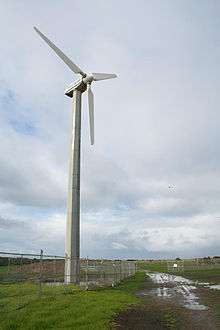
A wind generator, located on Black Rock Road, was erected in November 1987, as a demonstration unit, by the State Electricity Commission of Victoria and the Victorian Solar Energy Council (now Energy Victoria). The turbine, atop a 22-metre monopole, was of 60 kW capacity, and was manufactured by Westwind of Western Australia.[11]
As a consequence of the privatisation of electricity supply in Victoria, the generator was sold in 1994 to the Alternative Technology Association of Melbourne. December 1995 saw it sold again, to Michael Gunter, a member of the previous organisation. Electricity production ceased at 1200hrs on 17 May 2003 due to an electrical generator burn-out, caused by moisture, salt, and electrical flash-over.[12]
Local water utility Barwon Water bought the turbine the same year, restoring it to service in early 2004.[13] It generates approximately 80,000 kWh per year for the grid, with an estimated 90-95 per cent availability,[13] and produces between 7 kW and 10.3 kW of average power.[14]
References
- ↑ Australian Bureau of Statistics (31 October 2012). "Breamlea (SSC)". 2011 Census QuickStats. Retrieved 5 July 2014.
- 1 2 "SHIPWRECKS of PORT PHILLIP and THE RIP". Retrieved 2007-07-19.
- ↑ "Victoria Tower shipwreck". Department of Transport, Planning and Local Infrastructure. Retrieved 2014-03-04.
- ↑ "Geelong News". The Argus. 1941-10-17. Retrieved 2014-03-04.
- ↑ Premier Postal History. "Post Office List". Retrieved 2008-04-11.
- ↑ "Bancoora Surf Lifesaving Club History". Archived from the original on 2007-09-27. Retrieved 2007-07-19.
- ↑ Begg, Peter (1990). Geelong - The First 150 Years. Globe Press. ISBN 0-9592863-5-7.
- ↑ "EPA - Investigation at Black Rock near Geelong". Retrieved 2007-07-19.
- ↑ "$46M TREATMENT PLANT OPENED AT BLACK ROCK". Retrieved 2007-07-19.
- ↑ "The Bancoora 50th Anniversary". Bancoora Surf Life Saving Club. Retrieved 2014-03-04.
- ↑ "The History of Community Windfarms". Retrieved 2007-07-19.
- ↑ "Wind and energy data for Breamlea turbine". Retrieved 2007-07-19.
- 1 2 Enhar Sustainable Energy Solutions. "Case Study 3: Breamlea – 60kW community wind project" (PDF). NSW Small Wind Turbine Consumer Guide. NSW Office of Environment and Heritage. Retrieved 2011-09-30.
- ↑ "Michael Gunter - re: Electrical Distribution". Retrieved 2007-07-19.