Hara Island
| Native name: <span class="nickname" ">Hara saar | |
|---|---|
 | |
| Geography | |
| Location | Baltic Sea |
| Coordinates | 59°35′04″N 25°37′30″E / 59.58444°N 25.62500°ECoordinates: 59°35′04″N 25°37′30″E / 59.58444°N 25.62500°E |
| Area | 0.11 km2 (0.042 sq mi) |
| Highest elevation | 13 m (43 ft) |
| Administration | |
|
Estonia | |
| County | Harju |
| Municipality | Kuusalu Parish |
| Demographics | |
| Population | 0 |
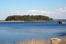
Hara (Estonian: Hara saar) is a small uninhabited island off the northern coast of Estonia in the Gulf of Finland with an area of 11 hectares. The highest point of the island is 13 meters above the sea level.
History
Prior to Second World War, the island had a few families as permanent inhabitants and a small fish factory operated there. After the war, the small harbour facing the island on the mainland was taken over by the Soviet Navy and used as a base for submarines. The island's inhabitants were removed.
This article is issued from Wikipedia - version of the 8/10/2013. The text is available under the Creative Commons Attribution/Share Alike but additional terms may apply for the media files.