Harmony Township, Posey County, Indiana
| Harmony Township Posey County | |
|---|---|
| Township | |
 | |
| Coordinates: 38°07′18″N 87°54′24″W / 38.12167°N 87.90667°WCoordinates: 38°07′18″N 87°54′24″W / 38.12167°N 87.90667°W | |
| Country | United States |
| State | Indiana |
| County | Posey |
| Government | |
| • Type | Indiana township |
| Area | |
| • Total | 35.93 sq mi (93.05 km2) |
| • Land | 35.24 sq mi (91.28 km2) |
| • Water | 0.68 sq mi (1.77 km2) |
| Elevation[1] | 407 ft (124 m) |
| Population (2000) | |
| • Total | 1,473 |
| • Density | 41.79/sq mi (16.14/km2) |
| FIPS code | 18-31504[2] |
| GNIS feature ID | 453374 |
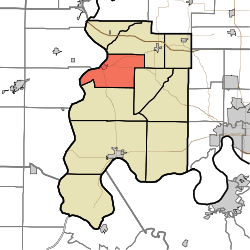
Harmony Township is one of ten townships in Posey County, Indiana. As of the 2000 census, its population was 1,473.
History
Harmony Township was organized in 1821.[3] A large share of the first settlers being Harmonites caused the name to be selected.[4]
The James Elliott Farm and New Harmony Historic District are listed on the National Register of Historic Places.[5]
Adjacent Townships
- Indiana
- Posey County
- Center Township (Southeast)
- Lynn Township (South)
- Robb Township (Northeast)
- Posey County
- Illinois
- White County
- Hawthorne Township (Southwest)
- Phillips Township (Northwest)
- White County
Cities
Unincorporated Places
References
- ↑ "US Board on Geographic Names". United States Geological Survey. 2007-10-25. Retrieved 2008-01-31.
- ↑ "American FactFinder". United States Census Bureau. Retrieved 2008-01-31.
- ↑ Leffel, John C. (1913). History of Posey County, Indiana. Standard Publishing Company. p. 78.
- ↑ History of Posey County, Indiana: from the earliest times to the present. Goodspeed Publishing Co. 1886. p. 278.
- ↑ National Park Service (2010-07-09). "National Register Information System". National Register of Historic Places. National Park Service.
External links
Municipalities and communities of Posey County, Indiana, United States | ||
|---|---|---|
| City | ||
| Towns | ||
| Townships | ||
| CDP | ||
| Other unincorporated communities | ||
| Footnotes | ‡This populated place also has portions in an adjacent county or counties | |
This article is issued from Wikipedia - version of the 10/28/2016. The text is available under the Creative Commons Attribution/Share Alike but additional terms may apply for the media files.