Harrison Township, Perry County, Ohio
| Harrison Township, Perry County, Ohio | |
|---|---|
| Township | |
|
Hills south of Crooksville | |
 Location of Harrison Township in Perry County | |
| Coordinates: 39°46′36″N 82°5′51″W / 39.77667°N 82.09750°WCoordinates: 39°46′36″N 82°5′51″W / 39.77667°N 82.09750°W | |
| Country | United States |
| State | Ohio |
| County | Perry |
| Area | |
| • Total | 23.3 sq mi (60.3 km2) |
| • Land | 23.2 sq mi (60.2 km2) |
| • Water | 0.1 sq mi (0.2 km2) |
| Elevation[1] | 778 ft (237 m) |
| Population (2000) | |
| • Total | 5,399 |
| • Density | 232.4/sq mi (89.7/km2) |
| Time zone | Eastern (EST) (UTC-5) |
| • Summer (DST) | EDT (UTC-4) |
| FIPS code | 39-33964[2] |
| GNIS feature ID | 1086781[1] |

Harrison Township is one of the fourteen townships of Perry County, Ohio, United States. The 2000 census found 5,399 people in the township, 1,745 of whom lived in the unincorporated portions of the township.[3]
Geography
Located in the northeastern part of the county, it borders the following townships:
- Newton Township, Muskingum County - north
- Clay Township, Muskingum County - northeast
- York Township, Morgan County - southeast
- Bearfield Township - south
- Pike Township - southwest
- Clayton Township - west
Several populated places are located in Harrison Township:
- The village of Crooksville, in the east
- Part of the village of Roseville, in the far northeast along the border with Muskingum County
- The unincorporated community of Milligan, in the south
Name and history
Harrison Township was organized in 1820, and named for William Henry Harrison, an Ohio legislator and afterward 5th President of the United States.[4] It is one of nineteen Harrison Townships statewide.[5]
Government
The township is governed by a three-member board of trustees, who are elected in November of odd-numbered years to a four-year term beginning on the following January 1. Two are elected in the year after the presidential election and one is elected in the year before it. There is also an elected township fiscal officer,[6] who serves a four-year term beginning on April 1 of the year after the election, which is held in November of the year before the presidential election. Vacancies in the fiscal officership or on the board of trustees are filled by the remaining trustees.
References
- 1 2 "US Board on Geographic Names". United States Geological Survey. 2007-10-25. Retrieved 2008-01-31.
- ↑ "American FactFinder". United States Census Bureau. Retrieved 2008-01-31.
- ↑ Perry County, Ohio — Population by Places Estimates Ohio State University, 2007. Accessed 15 May 2007.
- ↑ Colborn, Ephraim S. (1883). History of Fairfield and Perry Counties, Ohio. Brookhaven Press. p. 192.
- ↑ "Detailed map of Ohio" (PDF). United States Census Bureau. 2000. Retrieved 2007-02-16.
- ↑ §503.24, §505.01, and §507.01 of the Ohio Revised Code. Accessed 4/30/2009.
External links
Municipalities and communities of Perry County, Ohio, United States | ||
|---|---|---|
| Villages | 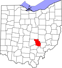 | |
| Townships | ||
| CDP | ||
| Unincorporated communities | ||
| Ghost towns | ||
| Footnotes | ‡This populated place also has portions in an adjacent county or counties | |