Harvard Center Historic District
|
Harvard Center Historic District | |
|
Harvard Town Hall | |
  | |
| Location | Harvard, Massachusetts |
|---|---|
| Coordinates | 42°29′52″N 71°35′1″W / 42.49778°N 71.58361°WCoordinates: 42°29′52″N 71°35′1″W / 42.49778°N 71.58361°W |
| Architect | multiple |
| Architectural style | Colonial, Greek Revival, Federal |
| NRHP Reference # | 97001091 [1] |
| Added to NRHP | September 22, 1997 |
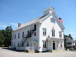
The Harvard Center Historic District is a historic district encompassing the traditional village center of Harvard, Massachusetts, USA. The district is centered on the town common, a triangular grassy space bounded by Elm Street, Still River Road, and Ayer Road. The common is ringed by residences, civic and religious buildings, and a small commercial area. The common was laid out when the town was founded in 1732, and has grown, mainly in periods of growth at the late 18th and late 19th/early 20th centuries. Most of the village's buildings post-date 1831.[2]
The district was added to the National Register of Historic Places in 1997.[1]
See also
- National Register of Historic Places listings in Worcester County, Massachusetts
- Nourse-Farwell House
References
- 1 2 National Park Service (2008-04-15). "National Register Information System". National Register of Historic Places. National Park Service.
- ↑ "MACRIS inventory record for Harvard Common Historic District". Commonwealth of Massachusetts. Retrieved 2015-03-27.
| Topics |  | ||||||||||||||||||||||||||||||
|---|---|---|---|---|---|---|---|---|---|---|---|---|---|---|---|---|---|---|---|---|---|---|---|---|---|---|---|---|---|---|---|
| Lists by county | |||||||||||||||||||||||||||||||
| Lists by city |
| ||||||||||||||||||||||||||||||
| Other lists | |||||||||||||||||||||||||||||||
| |||||||||||||||||||||||||||||||
This article is issued from Wikipedia - version of the 11/27/2016. The text is available under the Creative Commons Attribution/Share Alike but additional terms may apply for the media files.