Hawthorne Cottage
 | |
| Established | 1830 |
|---|---|
| Location | Brigus, Newfoundland, Canada |
| Website |
Hawthorne Cottage National Historic Site and www.historicsites.ca |
| Official name | Hawthorne Cottage National Historic Site of Canada |
| Designated | 1978 |
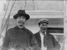
Hawthorne Cottage is a National Historic Site of Canada located in Brigus, Newfoundland and Labrador, Canada.[1][2] It is operated by the Historic Sites Association of Newfoundland and Labrador. It was the residence of Captain Bob Bartlett, a famed Arctic explorer. Bartlett is credited by marine historian Thomas Appleton with "the finest feat of leadership in Canadian Marine history" in his efforts to save the crew of the ill–fated Karluk under Arctic explorer Vilhjalmur Stefansson.
Built in 1830 by Brigus merchant John Leamon, Hawthorne Cottage came into the Bartlett family through Bartlett's mother, Mary Leamon Bartlett, granddaughter of John Leamon. In 1834 the house was moved 10 kilometers from its original site in Cochranedale to its current location in the centre of Brigus. In the house are the Benville Tearooms, once operated by Bartlett's mother and sisters.
The cottage combines features of Newfoundland vernacular architecture enhanced by intricate architectural details. The architecture of Hawthorne has been recognized by the Historic Sites and Monuments Board of Canada as typifying the refined lifestyle of Newfoundland outport merchant families of the 19th and early 20th centuries. It was designated a National Historic Site in 1978,[2] and has been a Federal Heritage Building since 1993.[3]
See also
References
- ↑ "Hawthorne Cottage". www.pc.gc.ca. 2009-04-24. Retrieved September 26, 2013.
- 1 2 Hawthorne Cottage National Historic Site of Canada. Canadian Register of Historic Places. Retrieved 8 July 2012.
- ↑ Hawthorne Cottage. Canadian Register of Historic Places. Retrieved 21 October 2013.
External links
- Hawthorne Cottage National Historic Site - Parks Canada official site
www.historicsites.ca- Historic Sites Association official site - Hawthorne Cottage under projects
| Provinces | |
|---|---|
| Territories | |
| Other countries | |
| |
Coordinates: 47°32′6.54″N 53°12′35.53″W / 47.5351500°N 53.2098694°W