Head of Grassy, Kentucky
| Head of Grassy, Kentucky | |
|---|---|
| Unincorporated community | |
 Head of Grassy, Kentucky | |
| Coordinates: 38°23′25″N 83°15′49″W / 38.39028°N 83.26361°WCoordinates: 38°23′25″N 83°15′49″W / 38.39028°N 83.26361°W | |
| Country | United States |
| State | Kentucky |
| County | Lewis |
| Elevation | 725 ft (221 m) |
| Time zone | Eastern (EST) (UTC-5) |
| • Summer (DST) | EDT (UTC-4) |
| ZIP code | 41135 |
| Area code(s) | 606 |
| GNIS feature ID | 493970[1] |
Head of Grassy is an unincorporated community in Lewis County, Kentucky, United States. Head of Grassy is located on Kentucky Route 59 and the Grassy Fork 14.7 miles (23.7 km) south-southeast of Vanceburg; its name is a misnomer, as it lies 5 miles (8.0 km) downstream from the head of the Grassy Fork.[2][3] Head of Grassy had a post office, which opened on November 19, 1878, and closed in 1982 or 1984.[4][5]
References
- ↑ "Head of Grassy". Geographic Names Information System. United States Geological Survey.
- ↑ State Primary Road System: Lewis County (PDF) (Map). Kentucky Transportation Cabinet. 2012. Retrieved June 11, 2012.
- ↑ Burdette, Dick (August 10, 1994). "Pursuit of Treasure Justifies Spot on Map". Lexington Herald-Leader.
- ↑ "Head of Grassy Post Office (historical)". Geographic Names Information System. United States Geological Survey.
- ↑ Burdette, Dick (October 21, 1996). "Head of Grassy's Treasure is Stamper". Lexington Herald-Leader.
Municipalities and communities of Lewis County, Kentucky, United States | ||
|---|---|---|
| Cities | 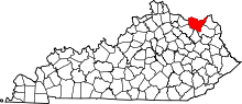 | |
| CDP |
| |
| Other unincorporated communities | ||
This article is issued from Wikipedia - version of the 9/29/2014. The text is available under the Creative Commons Attribution/Share Alike but additional terms may apply for the media files.