Hekimhan
| Hekimhan | |
|---|---|
 | |
 Hekimhan | |
| Coordinates: 38°48′59″N 37°55′58″E / 38.81639°N 37.93278°ECoordinates: 38°48′59″N 37°55′58″E / 38.81639°N 37.93278°E | |
| Country |
|
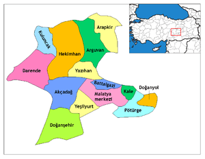
| Province | Malatya |
| Government | |
| • Mayor | Aliseydi Millioğulları (CHP) |
| • Kaymakam | Tunahan Efendioğlu |
| Area[1] | |
| • District | 1,898.04 km2 (732.84 sq mi) |
| Population (2012)[2] | |
| • Urban | 6,784 |
| • District | 25,629 |
| • District density | 14/km2 (35/sq mi) |
| Post code | 44400 |
| Website |
www |
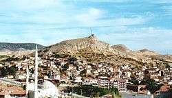
Hekimhan, (Kurdish: Hekîmxan), is a district of Malatya Province of Turkey. The mayor is Aliseidi Millioğulları (CHP). It is located in the upper Euphrates in Eastern Anatolia. Hekimhan is also located on the ancient silk road. The district population is 25,629. It is known for its mineral resources such as iron, chrome, dolomite, and torium, and was famous for its thin-shelled walnut. The famous apricots of Malatya are still widely raised in the district. Hekimhan is 1,075 m above sea level. The highest point in Hekimhan is Zurbahan mountain (2,091 m). Taşhan caravanserai (constructed by the Seljuk Turks), a Turkish bath and a mosque built by the Ottomans are some notable historical structures in the town. Hekimhan is also the birthplace of several famous politicians, singers, poets, writers, and other notorious figures such as Mehmet Ali Ağca.
Villages and Towns
References
- ↑ "Area of regions (including lakes), km²". Regional Statistics Database. Turkish Statistical Institute. 2002. Retrieved 2013-03-05.
- ↑ "Population of province/district centers and towns/villages by districts - 2012". Address Based Population Registration System (ABPRS) Database. Turkish Statistical Institute. Retrieved 2013-02-27.